This article needs additional citations for verification .(March 2016) |
 Satellite image | |
 | |
| Geography | |
|---|---|
| Location | Oceania |
| Coordinates | 10°46′48″S151°47′32″E / 10.78000°S 151.79222°E [1] |
| Archipelago | Louisiade Archipelago |
| Adjacent to | Solomon Sea |
| Total islands | 21 |
| Major islands | |
| Area | 4.55 km2 (1.76 sq mi) |
| Length | 21 km (13 mi) |
| Width | 10 km (6 mi) |
| Administration | |
| Province | |
| District | Samarai-Murua District |
| LLG [2] | Bwanabwana Rural LLG |
| Island Group | Calvados Chain |
| Largest settlement | Irai (pop. 20) |
| Demographics | |
| Population | 30 (2014) |
| Pop. density | 6.6/km2 (17.1/sq mi) |
| Ethnic groups | Papauans, Austronesians, Melanesians. |
| Additional information | |
| Time zone | |
| ISO code | PG-MBA |
| Official website | www |
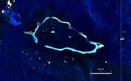
The Conflict Group is an atoll in Papua New Guinea. The group was sighted in 1879 by HMS Cormorant, by moonlight; it was named in 1880 by Bower, captain of HMS Conflict. [3] Irai Island is the center of population of the group.
The small Panasesa Island has an eco resort with a small staff.
In September 2022 the Papua New Guinea government ordered an investigation into the islands' ownership after their owner, Australian businessman Ian Gowrie Smith, attempted to sell them. [4]
