The geography of Papua New Guinea describes the eastern half of the island of New Guinea, the islands of New Ireland, New Britain and Bougainville, and smaller nearby islands. Together these make up the nation of Papua New Guinea in tropical Oceania, located in the western edge of the Pacific Ocean.
The Louisiade Archipelago is a string of ten larger volcanic islands frequently fringed by coral reefs, and 90 smaller coral islands in Papua New Guinea.

For administrative purposes, Papua New Guinea is divided into administrative divisions called provinces. There are 22 provinces, that includes the autonomous region (Bougainville) and the National Capital District.

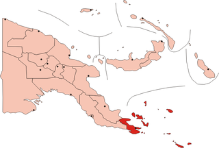
Milne Bay is a province of Papua New Guinea. Its capital is Alotau. The province covers 14,345 km² of land and 252,990 km² of sea, within the province there are more than 600 islands, about 160 of which are inhabited. The province has about 276,000 inhabitants, speaking about 48 languages, most of which belong to the Eastern Malayo-Polynesian branch of the Austronesian language family. Economically the province is dependent upon tourism, oil palm, and gold mining on Misima Island; in addition to these larger industries there are many small-scale village projects in cocoa and copra cultivation. The World War II Battle of Milne Bay took place in the province.

Milne Bay is a large bay in Milne Bay Province, south-eastern Papua New Guinea. More than 35 kilometres long and over 15 kilometres wide, Milne Bay is a sheltered deep-water harbor accessible via Ward Hunt Strait. It is surrounded by the heavily wooded Stirling Range to the north and south, and on the northern shore, a narrow coastal strip, soggy with sago and mangrove swamps. The bay is named after Sir Alexander Milne.

Normanby Island is a volcanic 1,000-square-kilometre (390 sq mi), L-shaped island, the southern most island in the D'Entrecasteaux Islands group. It is part of Milne Bay Province, Papua New Guinea.

Samarai is an island and former administrative capital in Milne Bay Province, Papua New Guinea.

The Anglican Church of Papua New Guinea is a province of the Anglican Communion. It was created in 1976 when the Province of Papua New Guinea became independent from the Province of Queensland in the Church of England in Australia following Papua New Guinea's independence in 1975.
The Dart Reefs is a group of reefs in the central area of the Ward Hunt Strait in Milne Bay Province of southeastern Papua New Guinea.

Alotau is the capital of Milne Bay Province, in the south-east of Papua New Guinea. It is located on the northern shore of Milne Bay. The town is located within Alotau Urban LLG.

Pana Tinani is an island in the Louisiade Archipelago in Milne Bay Province, Papua New Guinea.
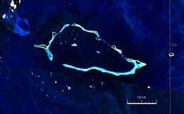
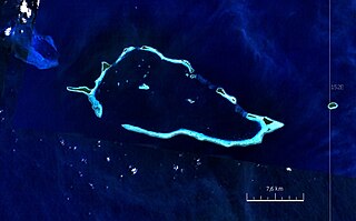
Pocklington Reef is a coral reef and a mostly submerged atoll in the far southeast of Papua New Guinea.
Auriroa Island is an island in Milne Bay Province of Papua New Guinea.
Lunn Island is a solitary island of Papua New Guinea in the Solomon Sea, belonging to the Louisiade Archipelago. It belongs to Milne Bay Province, to the ward of Conflict Group and is located between the Engineer Group, which is 8.3 kilometres to the west, and the Torlesse Islands, which are 18.3 kilometres to the east. The Deboyne Islands are another 22 kilometres eastward.
The Renard Islands are an archipelago in the Solomon Sea. Politically they belong to Milne Bay Province in the southeastern region of Papua New Guinea.

Yeina Island is an island of volcanic origin in the Southeast Louisiade Archipelago in Milne Bay Province, Papua New Guinea.
Nusam Island is an island in Papua New Guinea located in Milne Bay. It is situated 4 km south of Boagis and 6 km north of Nanon Islands.

The Jomard Islands are an uninhabited island group in the Coral Sea, belonging to Papua New Guinea, It lies to the east of Montemont Islands in the Louisiade Archipelago.

Bramble Haven is an atoll in the Louisiade Archipelago. its islands on the northern section are grouped as the Duperre Islands.
Nubara is island in Papua New Guinea. It is located in the east of the country, in the Milne Bay Province, about 700 km to the east of the Port Moresby.