Related Research Articles
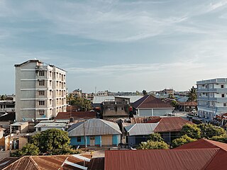
Tanga is a historic city and the capital of Tanga Region. The city is the most northernly port city of Tanzania to the west of the Indian Ocean on Tanga Bay. The city has a population of 393,429 in 2022. Tanga is governed by the Tanga City Council. The city is also home to the Port of Tanga. The name Tanga means "sail" in Swahili. The city is also the capital of Tanga District.
Ningi is a town and locality in the City of Moreton Bay, Queensland, Australia. In the 2016 census, the locality of Ningi had a population of 4,675 people. It is near Caboolture.

Tanga Region is one of Tanzania's 31 administrative regions. The region covers an area of 26,667 km2 (10,296 sq mi). The region is comparable in size to the combined land area of the nation state of Burundi. The regional capital is the municipality of Tanga city. Located in northeast Tanzania, the region is bordered by Kenya and Kilimanjaro Region to the north; Manyara Region to the west; and Morogoro and Pwani Regions to the south. It has a coastline to the east with the Indian Ocean. According to the 2012 national census, the region had a population of 2,045,205.

Tanga Island known during German East Africa as Toten Island in old colonial maps is a small uninhabited and protected island situated north of the city of Tanga's harbour on Tanga Bay in Tanga Region, Tanzania. It is within the Tanga Bay. The island is located entirely with the Tanga Coelacanth Marine Park (TCMP). The island is administered by Tanzania Marine Parks and Reserves.
Hope Island is a suburb in the City of Gold Coast, Queensland, Australia. In the 2016 census, Hope Island had a population of 11,186 people.
The Tanga Islands are an island group in Papua New Guinea, located north-east of New Ireland and part of the Bismarck Archipelago. Tanga is made up of four main islands — Boang, Maledok, Lif and Tefa — and a number of smaller, uninhabited islands. Boang consists entirely of a raised, relatively flat-topped plateau of Pleistocene, coralline limestone, which rises up to 170 m above sea level (asl.) and has sheer cliffs around a large part of its perimeter. The islands are the remnants of a stratovolcano which collapsed to form a caldera. Lif (283 m), Tefa (155 m), and Malendok (472 m) islands are on the caldera rim, while Bitlik and Bitbok islands are lava domes constructed near the center of the caldera.

The Feni Islands are an island group in Papua New Guinea, located east of New Ireland, at 4°4′20.35″S153°37′57.03″E. It is a part of the Bismarck Archipelago. The largest island of the group is Ambitle, the other island is Babase Island.
Bonville is a small town located on the Mid North Coast of New South Wales, Australia, 11 kilometres south of Coffs Harbour and in the local government area of City of Coffs Harbour. It has a population of 1,891 as of 2006. The town's name supposedly derives from "Bongol Bongol/Bongil Bongil", which in Gumbaingirr, means a place where one stays a long time.

Haefeli Glacier is a glacier, 2 miles (3 km) wide and 6 miles (10 km) long, situated on Pernik Peninsula, Loubet Coast in Graham Land, Antarctica, at the northwest side of Finsterwalder Glacier and flowing south-southwest toward the head of Lallemand Fjord. With Finsterwalder and Klebelsberg Glaciers, its mouth merges with Sharp Glacier where the latter enters the fjord. It was first surveyed in 1946–47 by the Falkland Islands Dependencies Survey and named by them for Robert Haefeli, a Swiss glaciologist.
Fenualoa is the second largest island in the Reef Islands, administratively located in the Solomon Islands province of Temotu.
Whatatutu is a small settlement in the northeast of New Zealand's North Island. It is located north of Te Karaka on the upper reaches of the Waipaoa River, close to its meeting with its tributaries, the Mangatu River and Waingaromia River.

Maziwi island officially, The Maziwe Island Marine Reserve is a unvegetated, protected island surrounded by coral reefs located about 8 kilometres (5.0 mi) south east of the town of Pangani off the northern coast of Tanga Region in Tanzania. The island is administered under Mwera ward of Pangani District. However, it is currently under the Tanga Marine Reserves System. It became a nature reserve in 1975. At one time the island was larger than its present area and was well-vegetated but with the loss of its coconut trees and scrub cover, it has suffered erosion and is now sometimes completely immersed at the time of the highest tides. Green sea turtles no longer nest on the island, but it is visited by numerous sea birds. The sea contains many species of coral and over two hundred species of fish. The reserve has received little active conservation work but management is now supported by levying a small fee on tourists which is used to compensate local fishermen for loss of income.
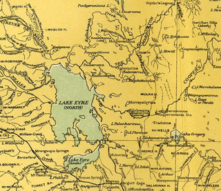
The Lake Ngapakaldi to Lake Palankarinna Fossil Area is a group of fossil sites located in the Australian state of South Australia within the Tirari Desert in the north-eastern part of the state's Far North region. The group has an overall area of 35 square kilometres (14 sq mi) and is located about 70 kilometres (43 mi) east of Lake Eyre and about 100 kilometres (62 mi) north-north-east of Marree, off the Birdsville Track near Etadunna Station.

The Pangani River, is a major river of northeastern Tanzania. It has two main sources: the Ruvu, which rises as Lumi at Kilimanjaro, passes through Lake Jipe, and empties into the Nyumba ya Mungu Reservoir, and the Kikuletwa River, coming from the west and mainly fed by rivers of Mount Meru in Arusha Region, which also enters into the Nyumba ya Mungu Reservoir in Kilimanjaro Region. Just after leaving the reservoir the stream becomes the main Pangani, which empties into the Indian Ocean in Tanga Region at the Tangan port town of Pangani.
Malendok Island is an island of the Tanga Islands of Papua New Guinea, located to the east of New Ireland. It is located to the south-west of Boang Island and north-east of Lif Island and Tefa Island. It covers 35 square kilometres (13.5 sq mi). Most inhabitants live in small hamlets on the coast. On the south-western side is a coconut plantation.
Tefa Island is a small island of the Tanga Islands of Papua New Guinea, located to the east of New Ireland. It is located to the south of Malendok Island and south of Lif Island. The main settlement is Tefa.
Lif Island is a small island of the Tanga Islands of Papua New Guinea, located to the east of New Ireland. It is located to the south-west of Malendok Island and north of Tefa Island. The main settlements are Balamfal and Kitkita.
Tanga people are a tribe of Papua New Guinea that lives in the Tanga Islands and Feni Islands of Tanir Rural LLG and three villages in the Matalai Rural LLG of Namatanai District of New Ireland Province. They speak the Tangga language which has since been split into three separate languages which are now spoken by the Tangans. These languages are: Niwer Mil, Warwar Feni and Fanamaket. Their population according to the 2011 Papua New Guinea Census Report is 12,466 people. Tubuan, Sokapana and Ingiet are the secret societies practised by the Tanga people. F.L.S. Bell has a collection on Tanga Islands in the University of Sydney Library in Australia.
The Tanga Coelacanth Marine Park (TCMP) is a Marine park in Tanzania, with the IUCN category II located within Tanga Region of Tanzania. The Tanga Coelacanth Marine Park (TACMP), which covers the entirety of Tanga City and all Coastal Areas from Tanga Bay and South of the Fishing Village of Kigombe, was Gazetted in 2009 by the Government of Tanzania (GoT) in recognition of the value of the Coelacanths and for their protection. Coelacanths have been spotted on Tanga Island, Mwambani Bay, Yambe Island, and Karange Island, all of which are part of the Park.
Yambe Island is protected, uninhabited historic island located directly east of the city of Tanga in Tanga District of Tanga Region in Tanzania. It is the largest island in Tanga region. It is located entirely with the Tanga Coelacanth Marine Park (TCMP). The island is administered by Tanzania Marine Parks and Reserves. The island is also home to medieval Swahili ruins that have yet to be excavated.
References
- ↑ Foster, Robert John (27 April 1995). Social Reproduction and History in Melanesia: Mortuary Ritual, Gift Exchange, and Custom in the Tanga Islands. Cambridge University Press. p. 30. ISBN 978-0-521-48332-2 . Retrieved 31 December 2012.
3°23′S153°18′E / 3.383°S 153.300°E
| | This article about an island in Papua New Guinea is a stub. You can help Wikipedia by expanding it. |