
Papua New Guinea, officially the Independent State of Papua New Guinea, is a country in Oceania that comprises the eastern half of the island of New Guinea and its offshore islands in Melanesia. It shares its only land border with Indonesia to the west and its other close neighbors are Australia to the south and the Solomon Islands to the east. Its capital, located on its southern coast, is Port Moresby. The country is the world's third largest island country, with an area of 462,840 km2 (178,700 sq mi).

Australian limes are species of the plant genus Citrus that are native to Australia and Papua New Guinea.

Milne Bay is a province of Papua New Guinea. Its capital is Alotau. The province covers 14,345 km2 of land and 252,990 km2 of sea, within the province there are more than 600 islands, about 160 of which are inhabited. The province has about 276,000 inhabitants, speaking about 48 languages, most of which belong to the Eastern Malayo-Polynesian branch of the Austronesian language family. Economically the province is dependent upon tourism, oil palm, and gold mining on Misima Island; in addition to these larger industries there are many small-scale village projects in cocoa and copra cultivation. The World War II Battle of Milne Bay took place in the province.
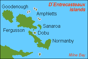
D'Entrecasteaux Islands are situated near the eastern tip of New Guinea in the Solomon Sea in Milne Bay Province of Papua New Guinea. The group spans a distance of 160 km (99 mi), has a total land area of approximately 3,100 km2 (1,197 sq mi) and is separated from the Papua New Guinea mainland by the 30 km (19 mi) wide Ward Hunt Strait in the north and the 18 km (11 mi) wide Goschen Strait in the south. D'Entrecasteaux Islands show signs of volcanism.

Fergusson Island is the largest island of the D'Entrecasteaux Islands, in Papua New Guinea. It has an area of 1,437 square kilometres (555 sq mi), and mostly consists of mountainous regions, covered by rain forests. There are three large volcanoes on the island.

Goodenough Island in the Solomon Sea, also known as Nidula Island, is the westernmost of the three large islands of the D'Entrecasteaux Islands in Milne Bay Province of Papua New Guinea. It lies to the east of mainland New Guinea and southwest of the Trobriand Islands. It is roughly circular in shape, measuring 39 by 26 kilometres with an area of 687 square kilometres (265 sq mi) and a shoreline of 116 kilometres (72 mi). From a coastal belt varying in width from 2 to 10 kilometres in width, the island rises sharply to the summit of Mount Vineuo, 2,536 metres (8,320 ft) above sea level, making it one of the most precipitous islands in the world. The small outlier Wagifa Island lies to the south-east of the island, and is included within Goodenough's administration.
The Dart Reefs is a group of reefs in the central area of the Ward Hunt Strait in Milne Bay Province of southeastern Papua New Guinea.
The Ward Hunt Strait is a 30 km wide stretch of water in Milne Bay, separating Papua New Guinea from Goodenough Island in the D'Entrecasteaux Islands. The Dart Reefs and Keast Reef are located in the centre of the channel. The strait was named in honour of George Ward Hunt, First Lord of the Admiralty (1874-1877), by Captain John Moresby.

This page is a list of districts of Papua New Guinea.

The Panniet naked-backed fruit bat, also known as the De Vis's Bare-backed Fruit Bat and Panaeati Bare-backed Fruit Bat, is a species of megabat in the family Pteropodidae. It roosts in groups, within caves and tree hollows.

France – Papua New Guinea relations are the foreign relations between France and Papua New Guinea. Official diplomatic relations were established in 1976. France has an embassy in Port Moresby but Papua New Guinea has no diplomatic representation in France. Papua New Guinea's embassy in Brussels covers France.

The Battle of Goodenough Island, also known as Operation Drake, was a battle of the Pacific campaign of World War II. The Allies landed on Goodenough Island, Papua, and clashed with a Japanese Kaigun Rikusentai. The Japanese troops had been stranded on the island during the Battle of Milne Bay in late August 1942. "Drake Force", consisting of the Australian 2/12th Battalion and attachments, landed on the southern tip of Goodenough Island at Mud Bay and Taleba Bay on 22 October, tasked with denying the Japanese use of the island prior to the Buna campaign. Following a short but intense fight, the Japanese forces withdrew to Fergusson Island on 27 October. After the battle, Goodenough Island was developed into a major Allied base for operations later in the war.
Mount Vineuo, also known as Mount Oiautukekea, is a mountain on Goodenough Island, Papua New Guinea. The mountain is 2,536 metres (8,320 ft) above sea level. The mountain is the highest peak in the D'Entrecasteaux Islands.
Diodio, or West Goodenough, is an Austronesian language spoken in Milne Bay Province, Papua New Guinea, on Goodenough Island, which it shares with Bwaidoka, Iduna, and Kaninuwa.
Kaninuwa, or Wataluma, is a major Oceanic language of Goodenough Island, Papua New Guinea.
Iduna is an Austronesian language spoken on Goodenough Island of Milne Bay Province of Papua New Guinea.
Citrus warburgiana. the kakamadu or New Guinea wild lime, grows on the south coast of the Papuan Peninsula near Alotau in Papua-New Guinea.
Rabaraba is a coastal village in Milne Bay Province on the southeastern coast of Papua New Guinea. It overlooks Goodenough Bay, and the Uga River flows into the bay to the south of the village.

Severe Tropical Cyclone Trevor was a powerful and large tropical cyclone that caused major damages across Papua New Guinea, Northern Territory and Queensland during March 2019. The twentieth tropical low, seventh tropical cyclone, and fourth severe tropical cyclone of the 2018-19 Australian region cyclone season, Trevor originated from a tropical low that formed to the east of Papua New Guinea.
Goodenough Island Rural LLG is a local-level government (LLG) of Milne Bay Province, Papua New Guinea.
