
Krakatoa, also transcribed Krakatau, is a caldera in the Sunda Strait between the islands of Java and Sumatra in the Indonesian province of Lampung. The caldera is part of a volcanic island group comprising four islands: two of which, Lang and Verlaten, are remnants of a previous volcanic edifice destroyed in eruptions long before the famous 1883 eruption; another, Rakata, is the remnant of a much larger island destroyed in the 1883 eruption.

Farallón de Pájaros, also known as Uracus or Urracas, is a small (2.3 km2) uninhabited volcanic island, the northernmost island in the Northern Mariana Islands chain.

The Bukit Barisan or the Barisan Mountains are a mountain range on the western side of Sumatra, Indonesia, covering nearly 1,700 km (1,050 mi) from the north to the south of the island. The Bukit Barisan range consists primarily of volcanoes shrouded in dense jungle cover, including Sumatran tropical pine forests on the higher slopes. The highest peak of the range is Mount Kerinci at 3,800 metres (12,467 ft). The Bukit Barisan Selatan National Park is situated towards the southern end of the range.
Manam, known locally as Manam Motu, is an island located in the Bismarck Sea across the Stephan Strait from Yawar on the northeast coast of mainland Papua New Guinea's Bogia District. The island is 10 kilometers wide, and was created by the activity of the Manam Volcano, one of the country’s most active. It was evacuated in 2004 and its residents resettled elsewhere in Papua New Guinea, but many have begun to return despite concerns of future volcanic activity.

Karangetang is a volcano on the north side of Siau Island off the coast of Sulawesi, Indonesia. The island is inhabited by 22,000 people. It is one of the most active volcanoes in Indonesia having erupted 41 times since 1675. A pyroclastic flow in 1997 killed three people.

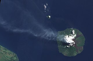
Karkar Island is an oval-shaped volcanic island located in the Bismarck Sea, about 30 kilometres off the north coast of mainland Papua New Guinea in Madang Province, from which it is separated by the Isumrud Strait. The island is about 25 km in length and 19 km in width. In the centre is an active volcano with two nested calderas.

Semeru, or Mount Semeru, is an active volcano in East Java, Indonesia. It is located in the subduction zone, where the Indo-Australia plate subducts under the Eurasia plate. It is the highest mountain on the island of Java. This stratovolcano is also known as Mahameru, meaning "The Great Mountain" in Sanskrit. The name derived from the Hindu cosmology's mountain of Meru or Sumeru, the abode of gods.

Anatahan is an island in the Northern Mariana Islands in the Pacific Ocean, and has one of the most active volcanoes of the archipelago. Formerly inhabited, the island currently does not have any population due to the always-present danger of volcanic eruptions. Anatahan is located 60 kilometers (32 nmi) northwest of Farallon de Medinilla and 120 km (65 nmi) north of Saipan.

Lava lakes are large volumes of molten lava, usually basaltic, contained in a volcanic vent, crater, or broad depression. The term is used to describe both lava lakes that are wholly or partly molten and those that are solidified.

Blup Blup Island is a small forested island off the northern coast of Papua New Guinea about 30 km offshore from Cape Girgir and is considered part of the Schouten Islands. It is located at latitude S 3°30'46" and longitude E 144°35'16". The island has a small population and is theoretically part of the Papuan province of East Sepik, although officially it is still a protectorate.

Billy Mitchell is a volcano in the central part of the island of Bougainville, just north-east of the Bagana Volcano in Papua New Guinea. It is a small pyroclastic shield truncated by a 2 km wide caldera filled by a crater lake. It is named after Billy Mitchell, a 20th-century United States Army general who is regarded as the father of the United States Air Force.

Calbuco is a stratovolcano in southern Chile, located southeast of Llanquihue Lake and northwest of Chapo Lake, in the Los Lagos Region, and close to the cities of Puerto Varas and Puerto Montt. With an elevation of 2,015 meters above sea level, the volcano and the surrounding area are protected within the Llanquihue National Reserve.

Bagabag is an island in the Madang Province of Papua New Guinea having a dormant volcano.

Kadovar is a volcanic island in Papua New Guinea north-east of the much larger island of New Guinea. The volcano erupted in January 2018 and the eruption is ongoing as of 2020. There were some heightened thermal phenomena in 1976.
