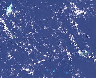
The Louisiade Archipelago is a string of ten larger volcanic islands frequently fringed by coral reefs, and 90 smaller coral islands in Papua New Guinea.
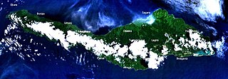
Misima is a volcanic island in the northwest of Louisiade Archipelago within Milne Bay Province of Papua New Guinea.
Sideia Island is an island in the Louisiade Archipelago in Milne Bay Province, Papua New Guinea.

Ptychosperma is a genus of flowering plant in the family Arecaceae. Most are native to Australia and/or New Guinea, with a few in the Solomon Islands and in Maluku Province of eastern Indonesia. Some have been cultivated abroad as house or garden plants, and reportedly naturalized in certain regions

The Panniet naked-backed fruit bat, also known as the De Vis's Bare-backed Fruit Bat and Panaeati Bare-backed Fruit Bat, is a species of megabat in the family Pteropodidae. It roosts in groups, within caves and tree hollows.
Hemenahei Island is an island in Papua New Guinea, part of the Calvados Chain within the Louisiade Archipelago. It is located to toward the eastern end of the Calvados Chain, in the Louisiade Archipelago, in the Milne Bay Province, between Pana Tinani in the East and Pana Wina in the West.

Pana Tinani is an island in the Louisiade Archipelago in Milne Bay Province, Papua New Guinea.

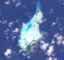
The Deboyne Islands are an atoll, composed of a group of reefs and islands in the north of the Louisiade Archipelago, Papua New Guinea.

The Duchateau Islands are an island group in the Coral Sea, belonging to Papua New Guinea. They lie to the east of Panarairai Island in the Louisiade Archipelago.
Auriroa Island is an island in Milne Bay Province of Papua New Guinea.
The Bonvouloir Islands are a group of uninhabited islands of Papua New Guinea. They are in the Louisiade Archipelago. The islands are located 100 kilometres northwest of Misima and form the northernmost group of the Louisiade Archipelago. The main islands are East Island, Panamole Island and Hastings Island
Daloloia Group are islands of Papua New Guinea. They are in the Louisiade Archipelago. They Include Bonura Island and Sarupai Island. The islands have a total area of 0.13 km2 (0.05 sq mi)
East Island is an island in Milne Bay Province of southeastern Papua New Guinea.
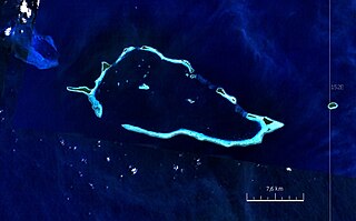
Panapompom Island is an island of Papua New Guinea. It is in the Deboyne Islands atoll of the Louisiade Archipelago.
Utian Island, also known as Brooker Island, is an island in Papua New Guinea, part of the Calvados Chain within the Louisiade Archipelago. It is located at the western end of the Calvados Chain, in the Louisiade Archipelago, in the Milne Bay Province.
Dolicholobium is a genus of flowering plants in the family Rubiaceae. The genus is found from central Malesia to the southwestern Pacific.

The Engineer Islands are an archipelago in the Solomon Sea belonging to Papua New-Guinea.
Mekinley Island is an island north of Sariba Island, and on the eastern side of China Strait, in Milne Bay Province, Papua New Guinea.
The Samarai Islands archipelago, part of the larger Louisiade Archipelago, is located 50 kilometres (31 mi) southeast of mainland New Guinea island, within the nation of Papua New Guinea.
The Louisiade Rural LLG is a local level government in the Milne Bay Province of Papua New Guinea. The LLG is situated in the central part of Louisiade Archipelago with Misima Island. At the 2011 census, it contained 23,335 residents living in 4,542 households. The LLG president is Benjamin Kuli. It launched its own microfinance scheme in December 2016.