
An archipelago, sometimes called an island group or island chain, is a chain, cluster, or collection of islands, or sometimes a sea containing a small number of scattered islands.

The Canary Islands, also known informally as the Canaries, are a Spanish Autonomous Community and archipelago in the Atlantic Ocean, in Macaronesia. At their closest point to the African mainland, they are 100 kilometres west of Morocco. They are the southernmost of the autonomous communities of Spain. The islands have a population of 2.2 million people and they are the most populous special territory of the European Union.

The Arctic Archipelago, also known as the Canadian Arctic Archipelago, is an archipelago lying to the north of the Canadian continental mainland, excluding Greenland.

The Lesser Antilles are a group of islands in the Caribbean Sea. Most of them are part of a long, partially volcanic island arc between the Greater Antilles to the north-west and the continent of South America. The islands of the Lesser Antilles form the eastern boundary of the Caribbean Sea where it meets the Atlantic Ocean. Together, the Lesser Antilles and the Greater Antilles make up the Antilles. The Lesser and Greater Antilles, together with the Lucayan Archipelago, are collectively known as the West Indies.

The Antilles is an archipelago bordered by the Caribbean Sea to the south and west, the Gulf of Mexico to the northwest, and the Atlantic Ocean to the north and east.

The Bismarck Archipelago is a group of islands off the northeastern coast of New Guinea in the western Pacific Ocean and is part of the Islands Region of Papua New Guinea. Its area is about 50,000 square km.
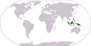
The Malay Archipelago is the archipelago between mainland Indochina and Australia. It has also been called the "Malay world," "Nusantara", "East Indies", Indo-Australian Archipelago, Spices Archipelago and other names over time. The name was taken from the 19th-century European concept of a Malay race, later based on the distribution of Austronesian languages.

The Chagos Archipelago or Chagos Islands is a group of seven atolls comprising more than 60 islands in the Indian Ocean about 500 kilometres (310 mi) south of the Maldives archipelago. This chain of islands is the southernmost archipelago of the Chagos–Laccadive Ridge, a long submarine mountain range in the Indian Ocean. In its north are the Salomon Islands, Nelson's Island and Peros Banhos; towards its south-west are the Three Brothers, Eagle, Egmont and Danger Island(s); southeast of these is Diego Garcia, by far the largest island. All are low-lying atolls, save for a few extremely small instances, set around lagoons.
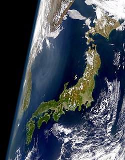
The Japanese archipelago is a group of 6,852 islands that form the country of Japan as well as the Russian island of Sakhalin. It extends over 3,000 km (1,900 mi) from the Sea of Okhotsk in the northwest to the East China and Philippine Seas in the southwest along the Pacific Ocean coast of the Eurasian continent, and consists of three island arcs from north to south: the Northeastern and Southwestern Japan Arcs, and the Ryukyu Island Arc. The Kuril Island Arc, the Daitō Islands, and the Nanpō Islands are not parts of the archipelago.

The Dahlak Archipelago is an Eritrean island group located in the Red Sea near Massawa, Eritrea. It consists of two large and 124 small islands. The pearl fisheries of the archipelago have been famous since Roman times and still produce a substantial number of pearls.

The Lucayan Archipelago, also known as the Bahama Archipelago, is an island group comprising the Commonwealth of The Bahamas and the British Overseas Territory of the Turks and Caicos Islands. The archipelago is in the western North Atlantic Ocean, north of Cuba and the other Antilles, and east and southeast of Florida.

The Archipelago Sea is a part of the Baltic Sea between the Gulf of Bothnia, the Gulf of Finland and the Sea of Åland, within Finnish territorial waters. By some definitions it contains the largest archipelago in the world by the number of islands, although many of the islands are very small and tightly clustered.

The Stockholm Archipelago is the largest archipelago in Sweden, and the second-largest archipelago in the Baltic Sea. Part of the archipelago has been designated as a Ramsar site since 1989.

Palmer Archipelago, also known as Antarctic Archipelago, Archipiélago Palmer, Antarktiske Arkipel or Palmer Inseln, is a group of islands off the northwestern coast of the Antarctic Peninsula. It extends from Tower Island in the north to Anvers Island in the south. It is separated by the Gerlache and Bismarck straits from the Antarctic Peninsula and Wilhelm Archipelago, respectively.

The Leeward Antilles are a chain of islands in the Caribbean – specifically, the southerly islands of the Lesser Antilles along the southeastern fringe of the Caribbean Sea, just north of the Venezuelan coast of the South American mainland. The Leeward Antilles, while among the Lesser Antilles, are not to be confused with the Leeward Islands to the northeast.

The British Indian Ocean Territory (BIOT) is a disputed Overseas Territory of the United Kingdom situated in the Indian Ocean halfway between Tanzania and Indonesia. The territory comprises the seven atolls of the Chagos Archipelago with over 1,000 individual islands – many very small – amounting to a total land area of 60 square kilometres (23 sq mi). The largest and most southerly island is Diego Garcia, 27 km2 (10 sq mi), the site of a Joint Military Facility of the United Kingdom and the United States.

The Solomon Islands archipelago is an archipelago in the western South Pacific Ocean, northeast of Australia. The archipelago is in the Melanesia subregion and bioregion of Oceania and forms the eastern boundary of the Solomon Sea. The many islands of the archipelago are distributed across Papua New Guinea and Solomon Islands. The largest island in the archipelago is the Autonomous Region of Bougainville, which lies within Papua New Guinea along with Nukumanu, Buka and a number of small associated islands. Much of the remainder falls within the territory of Solomon Islands and include the atolls of Ontong Java, Sikaiana, the raised coral atolls of Rennell and Bellona, and the high islands of Choiseul, Santa Isabel, the Shortlands, New Georgia, Guadalcanal, the Nggelas, Malaita, Makira, and the most southerly significant island, Nendö within the Santa Cruz Islands.

