
Tatau Island is an island of the Tabar Group of Papua New Guinea, located to the east of New Ireland and about a mile south of Simberi Island. [1]
Tatau Island is an island of the Tabar Group of Papua New Guinea, located to the east of New Ireland and about a mile south of Simberi Island. [1]

Qelelevu or Nggelelevu is a coral islet in Fiji, a member of the Ringgold Isles archipelago, which forms an outlier to the northern island of Vanua Levu.
Tablas Strait, also Tabuas Strait, is a strait in the Philippines separating Mindoro Island, Tablas Island, Panay and Romblon islands. The approximate depth of the strait is 545 meters (1,788 ft).
Nuakata Island is a small, mountainous island in the Goschen Strait south of Normanby Island and east of East Cape. It is part of Milne Bay Province in southeastern Papua New Guinea. Mount Tanorabwa is the highest point on the island at 1,072 feet.
Pistolet Bay is a natural bay located on the northern tip of the Great Northern Peninsula of the island of Newfoundland, in the Canadian province of Newfoundland and Labrador.

Sacol is an island in Zamboanga City, Philippines. It is composed mainly of mangrove swamps and has the Sacol hill as its most prominent feature at 781 feet (238 m). In historic times, the island served as a refuge for merchants and sailors from nearby Basilan and Zamboanga that was caught under severe weather. Currently, it is a known scuba diving spot and a source of seafood.
Casey Range is a jagged, razor-backed ridge and a few nunataks in a line extending north–south, standing 8 miles (13 km) west of David Range, in the Framnes Mountains. It was discovered by the British Australian and New Zealand Antarctic Research Expedition (BANZARE), 1929–31, under Douglas Mawson, who named it for Rt. Hon. Richard G. Casey.
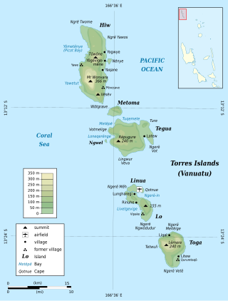
Lo is an island in the Torres group of islands, in northern Vanuatu. The island is located 2.25 miles from the Toga Island. As of 2009, the population of the island was 210. They speak the Lo dialect of the Lo-Toga language.
Cape Cockburn is a cape marking the northeastern extremity of Pasteur Peninsula on Brabant Island, in the Palmer Archipelago. The name appears on a chart based upon a British expedition under Henry Foster, 1828–31, who perhaps gave the name for George Cockburn, British naval officer and Admiral of the Fleet in 1851. The cape was charted by the French Antarctic Expedition, 1903–05, under Jean-Baptiste Charcot. The cape was photographed from the air by Falkland Islands and Dependencies Aerial Survey Expedition in 1956–57.
Whirlwind Glaciers is a set of four prominent converging glaciers which flow into the west side of Whirlwind Inlet on the east coast of the Antarctic Peninsula. Discovered by Sir Hubert Wilkins on his flight of December 20, 1928, the glaciers were so named because their relative position was suggestive of the radial cylinders of his Wright Whirlwind engine. The Whirlwind Glaciers, comprising Flint, Demorest, Matthes, and Chamberlin Glaciers, were photographed from the air by the United States Antarctic Service (USAS) in 1940; charted by the Falkland Islands Dependencies Survey (FIDS) in 1948.
Epsilon Island in the Antarctic is a small island lying between Alpha Island and the southern extremity of Lambda Island in the Melchior Islands, Palmer Archipelago. The island was roughly surveyed by Discovery Investigations personnel in 1927. The name, derived from epsilon, the fifth letter of the Greek alphabet, appears to have been first used on a 1946 Argentine government chart following surveys of the Melchior Islands by Argentine expeditions in 1942 and 1943.
The Havre Mountains are a large group of mountains forming the northwestern extremity of Alexander Island, Antarctica, extending 20 nautical miles (37 km) in an east–west direction between Cape Vostok and the Russian Gap. They were first seen in 1821 by a Russian expedition under Fabian Gottlieb von Bellingshausen and re-sighted by the Belgian Antarctic Expedition, 1897–99. They were roughly charted by the French Antarctic Expedition, 1908–10, under Jean-Baptiste Charcot, who named them for Le Havre, the French port from which the Pourquol Pas? sailed in 1908. The mountains were mapped in detail from air photos taken by the Ronne Antarctic Research Expedition, 1947–48, by D. Searle of the Falkland Islands Dependencies Survey in 1960.
Mount Riiser-Larsen is a prominent mountain, 870 m, standing at the northwest end of the Tula Mountains on the east side of Amundsen Bay. It was named by the British Australian New Zealand Antarctic Research Expedition (BANZARE) under Mawson in January 1930 for Captain Hjalmar Riiser-Larsen, the leader of a Norwegian expedition in the Norvegia which also explored the area in that season.

Cape Espiritu Santo, also known as Cape Espiritu Santo Mountains, is the northeastern point of the Northern Samar and the northernmost point of Samar Island. It was named Cabo Espiritu Santo by early European explorers, since it was discovered on the Feast of the Holy Spirit. It is also the first land sighted by the Spaniards when sailing from Nueva España, marks the end of their long sailing as they approaches the land and coast of the Ibabaw in the Philippines. Spanish navigators noted the mountains' value as they are visible 40 miles out to sea. There are two prominent summits in this location. One rises 1,481 ft (451.41 m) and the other 1,457 ft (444.09 m).
Malendok Island is an island of the Tanga Islands of Papua New Guinea, located to the east of New Ireland. It is located to the south-west of Boang Island and north-east of Lif Island and Tefa Island. It covers 35 square kilometres (13.5 sq mi). Most inhabitants live in small hamlets on the coast. On the south-western side is a coconut plantation.
Tsoilaunung Island is an island of Papua New Guinea, located to the east of New Hanover Island, to the north of New Ireland. The island is also known as Tsoi. Senta Pass separates it from Patio Island to its south.
Patio Island is a small island of Papua New Guinea, located to the southeast of New Hanover Island, to the north-west of New Ireland. Senta Pass separates it from Tsoilaunung Island to the north. To the south is Baudisson Island.
Abag Bay is a bay in Mindanao, Philippines. Abag is bight, which also contains the village of Kalaguhan.

Kamen Ariy, or Ary Rock is a small islet of the Commander Islands in the North Pacific Ocean, east of the Kamchatka Peninsula in Eastern Russia. These islands belong to the Kamchatka Krai of the Russian Federation. Kamen Ariy is about 8 km (5 mi) west of Tufted Puffin Rock and consists of two rocks. The northern rock is pointed and reaches a height of 45 m (150 ft). The southern rock is much flatter and only reaches a height of 2.1 m.
Masoni Island, also known as Sonit Island, is an island in Central Sulawesi, Indonesia. The island is low-lying, and is around 12 miles northwest of Timpaus Island. The waters surrounding the island are rich in corals, and the island is considered a regional water conservation area.
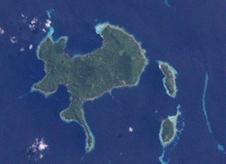
2°47′S151°58′E / 2.783°S 151.967°E
| | This Papua New Guinea–related geography article is a stub. You can help Wikipedia by expanding it. |