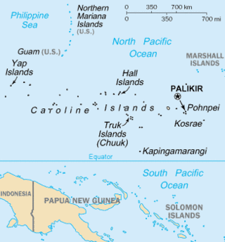
The Caroline Islands are a widely scattered archipelago of tiny islands in the western Pacific Ocean, to the north of New Guinea. Politically, they are divided between the Federated States of Micronesia (FSM) in the central and eastern parts of the group, and Palau at the extreme western end. Historically, this area was also called Nuevas Filipinas or New Philippines, because they were part of the Spanish East Indies and were governed from Manila in the Philippines.

The Bismarck Archipelago is a group of islands off the northeastern coast of New Guinea in the western Pacific Ocean and is part of the Islands Region of Papua New Guinea. Its area is about 50,000 square km.
Ruy López de Villalobos was a Spanish explorer who led a failed attempt to colonize the Philippines in 1544, attempting to assert Spanish control there under the terms of the treaties of Tordesillas and Zaragoza. Unable to feed his men through barter, raiding, or farming and unable to request resupply from Mexico due to poor knowledge of the Pacific's winds and currents, Villalobos abandoned his mission and fled to the Portuguese-held Moluccas, where he died in prison. He is chiefly remembered for some sources crediting him with naming Leyte the "Philippine Island" in honor of the Spanish crown prince Philip. The name was later extended across the entire Philippine Archipelago and its nation.

The Biak Islands are an island group of Papua province, eastern Indonesia in the Cenderawasih Bay 50 km off the north-western coast of the island of New Guinea. The group consists of the main islands of Biak, Supiori and Numfor, and numerous smaller islands, mostly covered in rain forest. The population of the archipelago is about 130,000.
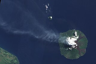
Manam, known locally as Manam Motu, is an island located in the Bismarck Sea across the Stephan Strait from Yawar on the northeast coast of mainland Papua New Guinea's Bogia District. The island is 10 kilometers wide, and was created by the activity of the Manam Volcano, one of the country’s most active. The island was evacuated in 2004 and its residents resettled elsewhere in Papua New Guinea, but many have begun to return despite concerns of future volcanic activity. Manam is still erupting as of January 2024.

Yapen is an island of Papua, Indonesia. The Yapen Strait separates Yapen and the Biak Islands to the north. It is in Cenderawasih Bay off the north-western coast of the island of New Guinea. To the west is Mios Num Island across the Mios Num Strait, and to the east Kurudu Island. Off the southeast coast of Yapen are the Amboi Islands and to the southwest are the Kuran Islands. Together these islands form the Yapen Islands Regency within the province of Papua. It is populated with communities of Yobi, Randowaya, Serui, and Ansus. Its highest point is 1,496 metres.
Yñigo, Íñigo, or Inigo Ortiz de Retez was a 16th-century Spanish maritime explorer of Basque origin, who navigated the northern coastline of the Pacific–Melanesian island of New Guinea and is credited with bestowing its current name.

Blup Blup Island is a small forested island off the northern coast of Papua New Guinea about 30 km offshore from Cape Girgir and is considered part of the Schouten Islands. It is located at latitude S 3°30'46" and longitude E 144°35'16". The island has a small population and is theoretically part of the Papuan province of East Sepik, although officially it is still a protectorate.
The Schouten Islands are a group of six small volcanic islands in the province of East Sepik in Papua New Guinea, north of the island of New Guinea. The group is also called Eastern Schouten Islands or Le Maire Islands to separate it from unrelated Schouten Islands in Indonesia. The combined land area is approximately 50 km2 (19 sq mi).
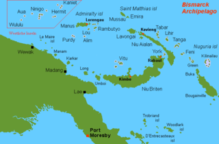
Wuvulu Island is part of the Western Islands of the Bismarck Archipelago in the western Pacific Ocean, part of Manus Province, Papua New Guinea. It is the westernmost island of the thirteen island groups that make up island chain in the archipelago. It is an island of volcanic origin encircled by a coral reef with a maximum height of three meters above sea level.

The Western Islands are a group of islands in the Bismarck Archipelago, and within Manus Province of the Islands Region, in northern Papua New Guinea.

The atoll starling is a species of starling in the family Sturnidae. It is found in northern Melanesia: Green Islands, Nuguria, Ninigo, Hermit Islands and Ontong Java Atoll. Its natural habitat is subtropical or tropical moist lowland forests. The species apparently nests in holes in trees. It is threatened by habitat loss.

Aua is an island in the Bismarck Archipelago. It is part of the Western Islands within Manus Province of northern Papua New Guinea.

Bagabag is an island in the Madang Province of Papua New Guinea having a dormant volcano.

Kadovar is a volcanic island in Papua New Guinea northeast of the much larger island of New Guinea. The volcano erupted in January 2018 and the eruption is ongoing as of 2023, although the activity level is generally considered to be low. There were some heightened thermal phenomena in 1976.
The Kaniet languages were two of four Western Admiralty Islands languages, a subgroup of the Admiralty Islands languages, the other two being Wuvulu-Aua and Seimat. The languages were spoken on the Kaniet Islands in western Manus Province of Papua New Guinea until the 1950s.
The Ninigo Islands are a group of 31 islands within the Western Islands of the Bismarck Archipelago, Papua New Guinea. Their coordinates are 1°16′S144°15′E.
The Hermit Islands are a group of 17 islands within the Western Islands of the Bismarck Archipelago, Papua New Guinea. Their coordinates are 1°30′S145°4′E.
Sae Island is the northernmost island within the Western Islands of the Bismarck Archipelago, Papua New Guinea. It is located just north-west of the Kaniet Islands, under which it is often subsumed, although the two are distinct. Another name for the Kaniet(-Sae) Islands is "Anchorite Islands".
Micronesian outliers are some islands near New Guinea inhabited by Micronesian settlers. All of the Micronesian outliers are in the Bismarck Sea and belong to Papua New Guinea. These islands are also known under the name Western Islands
