Basilaki Island

Last updated
Basilaki Island
Nickname: Moresby Island
Karta PG Louisiade isl.PNG
Louisiade Archipelago, Basilaki on the top left.
Papua New Guinea location map.svg
Red pog.svg
Basilaki Island
Location within Papua New Guinea
Geography
Location Oceania
Coordinates 10°37′19″S151°00′55″E / 10.62194°S 151.01528°E / -10.62194; 151.01528 [1]
Archipelago Louisiade Archipelago
Adjacent to Solomon Sea
Total islands1
Major islands
  • Basilaki
Area106 km2 (41 sq mi)
Length17 km (10.6 mi)
Width10 km (6 mi)
Coastline87.6 km (54.43 mi)
Highest elevation531 m (1742 ft)
Highest pointMount Kova Sina
Administration
Province Flag of Milne Bay.svg  Milne Bay
Island Group Samarai Islands
Island Group Basilaki Islands
Ward Split
Largest settlementYokowa(pop. 300)
Demographics
Population1883 (2014)
Pop. density18/km2 (47/sq mi)
Ethnic groups Papauans, Austronesians, Melanesians.
Additional information
Time zone
ISO code PG-MBA
Official website www.ncdc.gov.pg

Basilaki Island (Moresby Island [2] ) is an island in the Louisiade Archipelago in Milne Bay Province, Papua New Guinea. It is located at the eastern end of the New Guinea mainland.

Contents

History

First recorded sighting by Europeans was by the Spanish expedition of Luís Vaez de Torres on 18 July 1606, that charted it as San Buenaventura (after Saint Bonaventure). [3] [4] [5]

A party of French naturalists was believed to have been murdered in James Bay in October 1880. [6] [7]

This island was the scene of the murder of two sailors by natives in Hoopiron Bay, July 28, 1885. [8] The men were Captain John Friar and John Watkins, a carpenter of Lallah Rook, a schooner [9] registered in Saint John, New Brunswick. The vessel anchored in the bay to take on fresh water. After the murders, the crew sailed away. [10]

The murders were revenge taken for two unpaid-for deaths of natives in Friar's employ. Despite a two-day search of the island on October 16, by the crews of Governor Blackall, and HMS Diamond and HMS Raven, the murderers were not found, although the skulls of Friar and the carpenter were recovered and given a burial at sea. [11] Later Diamond returned and burned all the villages nearby. [12]

Three planes were ditched off the island in 1943, a P-38H Lightning, a P-38F Lightning, and a B-24D Liberator "The Leila Belle". [13]

Administration

The island is part of the following Wards:

All Wards belong to Bwanabwana Rural Local Level Government Area LLG, Samarai-Murua District, which are in Milne Bay Province. [14]

Geography

Basilaki is located on the east of Samarai Islands of the Louisiade Archipelago. The island is part of the Basilaki group. Mount Kova Sina (Fairfax) reaches a height of 531 meters, and is located at the center of the island. Mount Baiaule is 444 meters, and is located at the center of the island. Mount Salawie is 333 meters, and is located at the south of the island.

Demographics

The population of 1883 is living in 37 villages across the island. [15] Yokowa, where the school is located, is the largest village. although, the main dock is at Habani, at the other side of the island. List of villages: Hoopiron Bay, Gaiogaiokawasi, Baiaule, Hilomai, Habani, Halahalawuwu, Salewai, Wetoa, Dauyai, Hiliki, Towina, Kawalolo, Bedauna, Mwahui, Kalotau, Taladio, Agarauna, Huba, Yokowa, Dahidahina, Siu, Pihigole, Gigia, Doba, Tanubuibuina, Delina, Tutuila, Hewoli, Hamama, Duiauna, Nuanuatieu, Gogolabia, Hakalihi, Bogala, Kalamadau, Yahala.

Economy

The islanders, are farmers as opposed to eastern Louisiade Archipelago islanders. they grow Sago, Taro, and Yams for crops.

Transportation

There is a dock at Habani.

Related Research Articles

<span class="mw-page-title-main">Louisiade Archipelago</span> Archipelago of Papua New Guinea

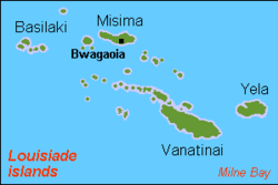
The Louisiade Archipelago is a string of ten larger volcanic islands frequently fringed by coral reefs, and 90 smaller coral islands in Papua New Guinea.

<span class="mw-page-title-main">Samarai</span> Island and former administrative capital in Papua New Guinea

Samarai is an island and former administrative capital in Milne Bay Province, Papua New Guinea.

Sideia Island is an island in the Louisiade Archipelago in Milne Bay Province, Papua New Guinea.

<span class="mw-page-title-main">Jomard Islands</span>

The Jomard Islands are an uninhabited island group in the Coral Sea, belonging to Papua New Guinea, It lies to the east of Montemont Islands in the Louisiade Archipelago.

Logea Island is a large island separating West Channel, East Channel and China Strait, just south of Milne Bay, in Milne Bay Province, Papua New Guinea.

Gesila Island is a small island separating West Channel, East Channel and China Strait, just south of Milne Bay, in Milne Bay Province, Papua New Guinea.

Galahi Island is an island off the northeast coast of Sariba, in Milne Bay Province, Papua New Guinea.

Igwali Island is an island north of Sariba Island, and on the eastern side of China Strait, in Milne Bay Province, Papua New Guinea.

Mekinley Island is an island north of Sariba Island, and on the eastern side of China Strait, in Milne Bay Province, Papua New Guinea.

Ito Island is an island between Sariba and Sideia, on the eastern side of China Strait, in Milne Bay Province, Papua New Guinea.

Saliba Island is a large island in Milne Bay Province, Papua New Guinea.

Populai Island is an island in the Louisiade Archipelago in Milne Bay Province, Papua New Guinea.

Dinana Island is an island in the Louisiade Archipelago in Milne Bay Province, Papua New Guinea.

Buiari Island is an island in the Louisiade Archipelago in Milne Bay Province, Papua New Guinea.

Kitai Bai Island is an islet in the Louisiade Archipelago, off the east coast of Basilaki Island, Milne Bay Province, Papua New Guinea.

Kitai Katoa Island is an island in the Louisiade Archipelago, off the east coast of Basilaki Island, Milne Bay Province, Papua New Guinea.

Kitai Lilivea Island is an island in the Louisiade Archipelago, off the east coast of Basilaki Island, Milne Bay Province, Papua New Guinea.

Kitai Katu Island is an island in the Louisiade Archipelago, off the east coast of Basilaki Island, Milne Bay Province, Papua New Guinea.

Kitai Bona Bona Island is an island in the Louisiade Archipelago, off the east coast of Basilaki Island, Milne Bay Province, Papua New Guinea.

<span class="mw-page-title-main">Samarai Islands</span> Archipelago in Papua New Guinea

The Samarai Islands archipelago, part of the larger Louisiade Archipelago, is located 50 kilometres (31 mi) southeast of mainland New Guinea island, within the nation of Papua New Guinea.

References

  1. Prostar Sailing Directions 2004 New Guinea Enroute, p. 168
  2. Admiralty hydrogr. dept (1879). "Moresby Island". The Australia directory. Vol.2. 2nd-6th ed. [With]. pp.  520–521.
  3. Coello, Francisco "Notas sobre los planos de las bahias descubiertas en el año 1606 en las islas de Espiritú Santo y de Nueva Guinea, que dibujo el capitán Don Diego de Prado y Tovar, en igual fecha"" Boletín de Sociedad Geográfica de Madrid, t.IV. 1º semestre 1878, Madrid, p.67
  4. Sharp, Andrew The discovery of the Pacific Islands Oxford, 1960, p.66.
  5. Brand, Donald D. The Pacific Basin: A History of its Geographical Explorations The American Geographical Society, New York, 1967, p.137.
  6. "Further massacres..." The Record-Union. Sacramento, California. 30 Dec 1880. p. 4. Retrieved 21 July 2015 via Newspapers.com.
  7. "Further atrocities in the South Seas". Daily Honolulu Press. 19 Feb 1881. p. 1. Retrieved 21 July 2015 via Newspapers.com.
  8. Resurgo says July 2
  9. Resurgo says barque
  10. Pincombe, C. Alexander; Larracey, Edward W. (1990). Resurgo : the history of Moncton. Vol. 1. New Brunswick, Can.: City of Moncton. pp. 210–211. ISBN   0969463405.
  11. Sir Peter Scratchley (1887). "New Guinea". Australian defences and New Guinea. Macmillan. p.  344.
  12. Sir Peter Scratchley (1887). "Sir Peter's Diary". Australian defences and New Guinea. Macmillan. p.  305, fn1.
  13. Basilaki Island Pacific Wrecks
  14. "LLG map" (PDF). Archived from the original (PDF) on 2010-08-11. Retrieved 2016-03-16.
  15. "map". Archived from the original on 2016-03-16. Retrieved 2016-03-16.