
The Hermit Islands are a group of 17 [1] islands within the Western Islands of the Bismarck Archipelago, Papua New Guinea. Their coordinates are 1°30′S145°4′E / 1.500°S 145.067°E . [1]
The Hermit Islands are a group of 17 [1] islands within the Western Islands of the Bismarck Archipelago, Papua New Guinea. Their coordinates are 1°30′S145°4′E / 1.500°S 145.067°E . [1]

The first sighting by Europeans of Hermit islands was by the Spanish navigator Iñigo Órtiz de Retes on 29 July 1545 when on board of the carrack San Juan tried to return from Tidore to New Spain. He charted them as La Caimana (a female caiman in Spanish). [2] When passing by, Ortiz de Retes reported that some natives got near the ship who flung arrows by hand without bows, that were made of flint suitable for striking fire. [3] These islands belong to Micronesian outliers.
On 17 June 1944, after returning from a bombing mission, 11 aircrew were bailed out from the B-24 Liberator Dropsnoot over the Hermit Islands and landed in rough seas approximately two miles from the southeast of Jalun Island. Four drowned, while the other seven were cared for by natives until being rescued.
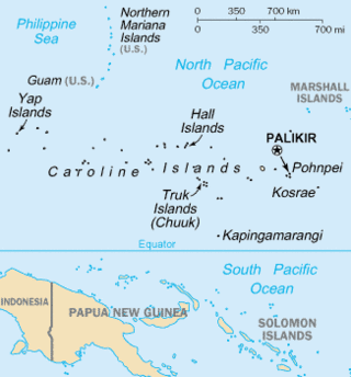
The Caroline Islands are a widely scattered archipelago of tiny islands in the western Pacific Ocean, to the north of New Guinea. Politically, they are divided between the Federated States of Micronesia (FSM) in the central and eastern parts of the group, and Palau at the extreme western end. Historically, this area was also called Nuevas Filipinas or New Philippines, because they were part of the Spanish East Indies and were governed from Manila in the Philippines.
Ruy López de Villalobos was a Spanish explorer who led a failed attempt to colonize the Philippines in 1544, attempting to assert Spanish control there under the terms of the treaties of Tordesillas and Zaragoza. Unable to feed his men through barter, raiding, or farming and unable to request resupply from Mexico due to poor knowledge of the Pacific's winds and currents, Villalobos abandoned his mission and fled to the Portuguese-held Moluccas, where he died in prison. He is chiefly remembered for some sources crediting him with naming Leyte the "Philippine Island" in honor of the Spanish crown prince Philip. The name was later extended across the entire Philippine Archipelago and its nation.

The Biak Islands are an island group of Papua province, eastern Indonesia in the Cenderawasih Bay 50 km off the north-western coast of the island of New Guinea. The group consists of the main islands of Biak, Supiori and Numfor, and numerous smaller islands, mostly covered in rain forest. The population of the archipelago is about 130,000.
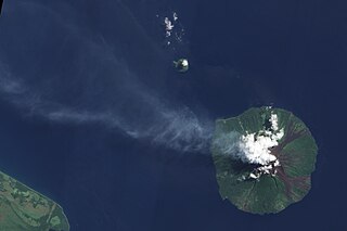
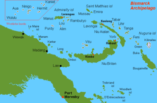
Manam, known locally as Manam Motu, is an island located in the Bismarck Sea across the Stephan Strait from Yawar on the northeast coast of mainland Papua New Guinea's Bogia District. The island is 10 kilometers wide, and was created by the activity of the Manam Volcano, one of the country’s most active. The island was evacuated in 2004 and its residents resettled elsewhere in Papua New Guinea, but many have begun to return despite concerns of future volcanic activity. Manam is still erupting as of January 2024.

Yapen is an island of Papua, Indonesia. The Yapen Strait separates Yapen and the Biak Islands to the north. It is in Cenderawasih Bay off the north-western coast of the island of New Guinea. To the west is Mios Num Island across the Mios Num Strait, and to the east Kurudu Island. Off the southeast coast of Yapen are the Amboi Islands and to the southwest are the Kuran Islands. Together these islands form the Yapen Islands Regency within the province of Papua. It is populated with communities of Yobi, Randowaya, Serui, and Ansus. Its highest point is 1,496 metres.
Kapingamarangi is an atoll and a municipality in the state of Pohnpei of the Federated States of Micronesia. It is by far the most southerly atoll or island of the country and the Caroline Islands, 300 km (190 mi) south of the next southerly atoll, Nukuoro, and 740 km (460 mi) southwest of the main island of Pohnpei state; it forms a Polynesian outlier.

Karkar Island is an oval-shaped volcanic island located in the Bismarck Sea, about 30 kilometres off the north coast of mainland Papua New Guinea in Madang Province, from which it is separated by the Isumrud Strait. The island is about 25 km in length and 19 km in width. In the centre is an active volcano with two nested calderas.
Yñigo, Íñigo, or Iñigo Ortiz de Retes was a 16th-century Spanish maritime explorer of Basque origin, who navigated the northern coastline of the Pacific–Melanesian island of New Guinea and is credited with bestowing its current name.

Blup Blup Island is a small forested island off the northern coast of Papua New Guinea about 30 km offshore from Cape Girgir and is considered part of the Schouten Islands. It is located at latitude S 3°30'46" and longitude E 144°35'16". The island has a small population and is theoretically part of the Papuan province of East Sepik, although officially it is still a protectorate.
The Schouten Islands are a group of six small volcanic islands in the province of East Sepik in Papua New Guinea, north of the island of New Guinea. The group is also called Eastern Schouten Islands or Le Maire Islands to separate it from unrelated Schouten Islands in Indonesia. The combined land area is approximately 50 km2 (19 sq mi).

Supiori is an island of the Schouten Islands archipelago in Cenderawasih Bay, just west of Biak island in Papua Province, Western New Guinea, northeastern Indonesia.
Wuvulu Island is part of the Western Islands of the Bismarck Archipelago in the western Pacific Ocean, part of Manus Province, Papua New Guinea. It is the westernmost island of the thirteen island groups that make up island chain in the archipelago. It is an island of volcanic origin encircled by a coral reef with a maximum height of three meters above sea level.
Numfor is one of the Biak Islands in Papua province, northeastern Indonesia.

Aua is an island in the Bismarck Archipelago. It is part of the Western Islands within Manus Province of northern Papua New Guinea.

Mission Santa Cruz de San Sabá was one of the Spanish missions in Texas. It was established in April 1757, along with the Presidio San Luis de las Amarillas, later renamed Presidio of San Sabá, in what is now Menard County. Located along the San Saba River, the mission was intended to convert members of the Lipan Apache tribe. Although no Apache ever resided at the mission, its existence convinced the Comanche that the Spanish had allied with the Comanche's mortal enemy. In 1758 the mission was destroyed by an estimated 2,000 warriors from the Comanche, Tonkawa, Yojuane, Bidai and Hasinai tribes. It was the only mission in Texas to be completely destroyed by Native Americans. The Indians did not attack the nearby presidio.

Bagabag is an island in the Madang Province of Papua New Guinea having a dormant volcano.

Kadovar is a volcanic island in Papua New Guinea northeast of the much larger island of New Guinea. The volcano erupted in January 2018 and the eruption is ongoing as of 2023, although the activity level is generally considered to be low. There were some heightened thermal phenomena in 1976.

The Ninigo Islands are a group of 31 islands within the Western Islands of the Bismarck Archipelago, Papua New Guinea. Their coordinates are 1°16′S144°15′E.
The Kaniet Islands are the easternmost group islands within the Western Islands of the Bismarck Archipelago, Papua New Guinea. It consists four islands and one islet. Their coordinates are 0°54′S145°32′E, located north-east of the Hermit Islands. Sae Island is a nearby island often subsumed under the Kaniet(-Sae) Islands, albeit the two are distinct. Another name for the Kaniet(-Sae) Islands is "Anchorite Islands".
Sae Island is the northernmost island within the Western Islands of the Bismarck Archipelago, Papua New Guinea. It is located just north-west of the Kaniet Islands, under which it is often subsumed, although the two are distinct. Another name for the Kaniet(-Sae) Islands is "Anchorite Islands".
| | This Manus Province geography article is a stub. You can help Wikipedia by expanding it. |