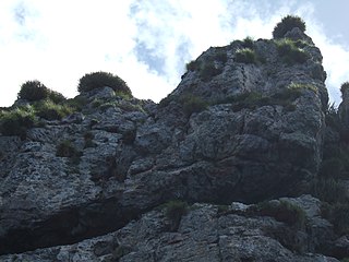
The Poor Knights Islands are a group of islands off the east coast of the Northland Region of the North Island of New Zealand. They lie 50 kilometres (31 mi) to the northeast of Whangārei, and 22 kilometres (14 mi) offshore halfway between Bream Head and Cape Brett. Uninhabited since the 1820s, they are a nature reserve and popular underwater diving spot, with boat tours typically departing from Tutukaka. The Poor Knights Islands Marine Reserve surrounds the island.

Kornhill and Kornhill Gardens are apartment buildings on the northern slope of Mount Parker, in Quarry Bay, Hong Kong Island, Hong Kong. Kornhill is a private housing estate and Kornhill Gardens is a Private Sector Participation Scheme estate. The total population is approximately 30,000.

The Admiralty Islands languages are a group of some thirty Oceanic languages spoken on the Admiralty Islands. They may include Yapese, which has proven difficult to classify.

Baluan Island is the southernmost island of the Admiralty Islands group which makes up the majority of Manus Province in Papua New Guinea. It belongs to the Pam Islands, an island subgroup to the south of Lou Island. It is formed from an extinct volcano, also named Baluan.

The Solomon Sea is a sea located within the Pacific Ocean. It lies between Papua New Guinea and Solomon Islands. Many major battles were fought there during World War II.

Rambutyo Island is one of the Admiralty Islands in the Bismarck Archipelago. Administratively, Rambutyo Island is part of Manus Province, Papua New Guinea. The population (unknown) is concentrated on the west coast. Villages include Mouklen and Lengkau.

District of Shelburne, officially named the Municipality of the District of Shelburne, is a district municipality comprising the eastern section of Shelburne County, Nova Scotia, Canada, but does not include the Towns of Shelburne or Lockeport. Statistics Canada classifies the district municipality as a municipal district. It is home to the Bowers Meadows Wilderness Area.

Graham Street is a street in Hong Kong and the location of Graham Street Market, one of the oldest continuously operating street markets in Hong Kong.
Kaarma is a village in Saaremaa Parish, Saare County, on the island of Saaremaa, Estonia. The Estonian communist politician Viktor Kingissepp was born here in 1888.

Langlütjen is the name of the two uninhabited artificial islands created in the 19th century, Langlütjen I and Langlütjen II, north off the coast of the district Wesermarsch in Lower Saxony, Germany. The islands are administered by the town of Nordenham. Their size is 16,000 and 17,000 square metres, respectively.

The Anglican Diocese of Bendigo is a diocese of the Anglican Church of Australia. It is situated in the Bendigo region of the state of Victoria, Australia. Its geographic remit extends from that part of Victoria that lies north of the Great Dividing Range and west of the Goulburn River to the border with the state of South Australia. The diocesan cathedral is St Paul's Cathedral, Bendigo. The diocese was separated from the Diocese of Melbourne in 1902, with Henry Archdall Langley installed as the first bishop. The current bishop, Matt Brain, was installed on 17 February 2018.
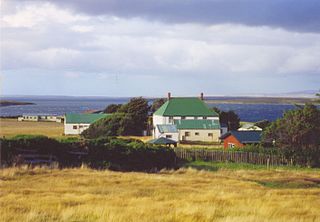
Teal Inlet, once named Evelyn Station, is a settlement on East Falkland, in the Falkland Islands, on the south shore of Salvador Water. It is overshadowed by Jack's Mountain.

Smooth Island, is a privately owned island with an area of 59.31 ha lying close to the south-eastern coast of Tasmania, Australia. The island is part of the Sloping Island Group situated in Norfolk Bay and surrounded by the Tasman and Forestier Peninsulas. The towns Dunalley and Murdunna are nearby. Smooth Island differs from other Tasmanian islands as it has an unencumbered freehold title down to the high-water mark.
Visscher Island is an island, with an area of 3.4 ha, in south-eastern Tasmania, in Australia.
Aukum, officially Mount Aukum, is an unincorporated community in El Dorado County, California. It is located 1 mi (1.6 km) northeast of River Pines, 1.2 mi (1.9 km) south of Mount Aukum and 8.5 mi (13.7 km) northeast of Plymouth, at an elevation of 2,155 feet (657 m). The ZIP code is 95656.
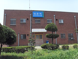
Naepan station is a signal box on the Gyeongbu Line in Yeondong-myeon, Sejong City, South Korea.

King George Island is an island in south-eastern Australia. It is part of the Sloping Island Group, lying close to the south-eastern coast of Tasmania around the Tasman and Forestier Peninsulas. The island was once inhabited and farmed and contains the ruins of two buildings on its eastern side. A conservation covenant is in place on this island.
Baluan-Pam is an Oceanic language of Manus Province, Papua New Guinea. It is spoken on Baluan Island and on nearby Pam Island. The number of speakers, according to the latest estimate based on the 2000 Census, is 2,000. Speakers on Baluan Island prefer to refer to their language with its native name Paluai.
Toprak Island is an Aegean island of Turkey. It is uninhabited. At 37°16′58″N27°21′59″E it is administratively a part of Milas ilçe (district) of Muğla Province. Its area is about 1 square kilometre (0.39 sq mi). Its distance from the mainland (Anatolia) is about 4.5 kilometres (2.8 mi).

The Eastern Litwin Bay Important Bird Area lies between Stigant Point and Davey Point on the northern coast of King George Island in the South Shetland Islands of Antarctica. Here a 500 ha Important Bird Area (IBA) has been designated by BirdLife International because it supports breeding seabirds, notably large numbers of chinstrap penguins with counts of 8,500 to 12,500 breeding pairs made in the area. The site comprises islets in Litwin Bay, the adjacent coast of King George Island and the intervening sea.

