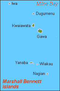
Marshall Bennett Islands (also known as the Marshall Bennets [1] ) are several islands in Milne Bay, Papua New Guinea.

Marshall Bennett Islands (also known as the Marshall Bennets [1] ) are several islands in Milne Bay, Papua New Guinea.
They consist of:
They are usually considered to be part of the Woodlark Islands group. Of the islands only Dugumenu is uninhabited but is used by neighbouring islanders for the growing of coconuts.

An atoll, sometimes known as a coral atoll, is a ring-shaped coral reef, including a coral rim that encircles a lagoon partially or completely. There may be coral islands or cays on the rim.

The Torres Strait is a strait between Australia and the Melanesian island of New Guinea. It is 151 km (94 mi) wide at its narrowest extent. To the south is Cape York Peninsula, the northernmost extremity of the Australian mainland. To the north is the Western Province of Papua New Guinea. It is named after the Spanish navigator Luís Vaz de Torres, who sailed through the strait in 1606.

Flint Island is an uninhabited coral island in the central Pacific Ocean, part of the Southern Line Islands under the jurisdiction of Kiribati. In 2014 the Kiribati government established a twelve-nautical-mile exclusion zone around each of the southern Line Islands.

Kili Island or Kili Atoll is a small, 81 hectares island located in the Marshall Islands in the Pacific Ocean. It is the temporary home of 548 inhabitants who are descended from islanders who originally lived on Bikini Atoll. They were relocated when they agreed to let the U.S. government temporarily use their home for nuclear testing in 1945. Kili Island became their home after two prior relocations failed. The island does not have a natural lagoon and cannot produce enough food to enable the islanders to be self-sufficient. It is part of the legislative district of the Ralik Chain of the Marshall Islands. The island is approximately 48 kilometers (30 mi) southwest of Jaluit. It is one of the smallest islands in the Marshall Islands.

Bokak Atoll or Taongi Atoll is an uninhabited coral atoll in the Ratak Chain of the Marshall Islands, in the North Pacific Ocean. Due to its relative isolation from the main islands in the group, Bokak's flora and fauna has been able to exist in a pristine condition.

The Solomon Sea is a sea located within the Pacific Ocean. It lies between Papua New Guinea and the Solomon Islands. Many major battles were fought there during World War II.

Bikar Atoll is an uninhabited atoll in the Ratak Chain of the Marshall Islands. It is one of the smallest atolls in the Marshalls. Due to its relative isolation from the main islands in the group, Bikar's flora and fauna has been able to exist in a relatively pristine condition.

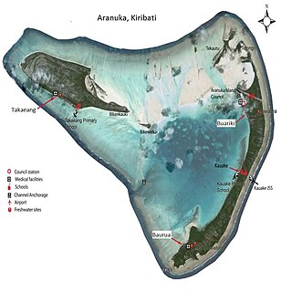
Aranuka is an atoll of Kiribati, located just north of the equator, in the Gilbert Islands. It has an area of 11.6 square kilometres and a population of 1,057 in 2010. By local tradition, Aranuka is the central island of the Gilbert group.

Rossel Island is the easternmost island of the Louisiade Archipelago, within the Milne Bay Province of Papua New Guinea. Tree Islet is situated 1.5 miles (2.4 km) to the north-west, while Wule Island is situated 1.5 miles (2.4 km) westward.

Chesterfield Islands are a French archipelago of New Caledonia located in the Coral Sea, 550 km northwest of Grande Terre, the main island of New Caledonia. The archipelago is 120 km long and 70 km broad, made up of 11 uninhabited islets and many reefs. The land area of the islands is less than 10 km².

Tupai, also called Motu Iti, is a low-lying atoll in Society Islands, French Polynesia. It lies 19 km to the north of Bora Bora and belongs to the western Leeward Islands. This small atoll is only 11 km² in area. Its broad coral reef encloses a shallow sandy lagoon. There are almost continuous long wooded motus on Tupai's reef. Tupai has no permanent residents apart from some workers in the coconut plantations. There is a private airfield on Tupai; it was inaugurated in 2001, and its use is restricted.

Toke Atoll or Taka Atoll is a small, uninhabited coral atoll in the Ratak Chain of the Marshall Islands. It is one of the smaller atolls in the Marshalls and located at 11°17′N169°37′E. It is visited regularly by the residents of nearby Utirik Atoll.

Ahunui or Nga-taumanga is a small atoll of the eastern Tuamotu Archipelago in French Polynesia. It is located 55 km SSE of Paraoa Atoll and 120 km WSW of Vairaatea.

Mischief Reef, also known in Mandarin Chinese: 美濟礁/美济礁; pinyin: Měijì Jiāo; lit. 'Meiji Reef'; Panganiban Reef ; Vietnamese: Đá Vành Khăn, is a reef/atoll surrounding a large lagoon in the SE of Dangerous Ground in the east of the Spratly Islands in the South China Sea. It is located 250 kilometres (130 nmi) west of Palawan Island of the Philippines. Activities by the People's Republic of China (PRC) in the mid-2010s have created a large artificial island on the atoll which has included an approximately 2,700 metres (8,900 ft) runway and associated airfield.

Fayu Atoll is an uninhabited atoll in the state of Chuuk, Federated States of Micronesia. It is located 36 km to the west of Nomwin Atoll and 104 km north of Chuuk Lagoon.

Kuop or Neoch is an atoll in the state of Chuuk, Federated States of Micronesia. Its area of 0.5 km2 is uninhabited.
Dugumenu Island is an island in Papua New Guinea. It is a member of the Marshall Bennett Islands and therefore belongs to Milne Bay Province. The island is about 180 hectares in area and uninhabited, but islanders from nearby Kwaiwatta and Gawa islands use Dugumenu for coconut production and probably fishing.

The Jomard Islands are an uninhabited island group in the Coral Sea, belonging to Papua New Guinea, It lies to the east of Montemont Islands in the Louisiade Archipelago.

Rowa Islands are an uninhabited archipelago in Torba Province of Vanuatu in the Pacific Ocean. The Rowa are a part of larger Banks Islands archipelago. The islands are a natural border between Melanesia and Polynesia; they are one of the most beautiful places in the South Pacific Ocean and an integral part of a vast system of atolls and reefs.
Coordinates: 8°50′S151°55′E / 8.833°S 151.917°E