Castile or Castille is a territory of imprecise limits located in Spain. The use of the concept of Castile relies on the assimilation of a 19th-century determinist geographical notion, that of Castile as Spain's centro mesetario with a long-gone historical entity of diachronically variable territorial extension.

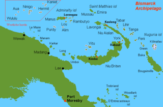
The Bismarck Archipelago is a group of islands off the northeastern coast of New Guinea in the western Pacific Ocean and is part of the Islands Region of Papua New Guinea. Its area is about 50,000 square km.

La Palma, also known as La isla bonita and historically San Miguel de La Palma, is the most northwesterly island of the Canary Islands, Spain, which is a Spanish autonomous community and archipelago in Macaronesia in the North Atlantic Ocean. La Palma has an area of 708.32 square kilometres (273.48 sq mi) making it the fifth largest of the eight main Canary Islands. The total population at the start of 2023 was 84,338, of which 15,522 lived in the capital, Santa Cruz de La Palma and 20,375 in Los Llanos de Aridane. Its highest mountain is the Roque de los Muchachos, at 2,426 metres (7,959 ft), being second among the peaks of the Canaries after the Teide massif on Tenerife.
Ruy López de Villalobos was a Spanish explorer who led a failed attempt to colonize the Philippines in 1544, attempting to assert Spanish control there under the terms of the treaties of Tordesillas and Zaragoza. Unable to feed his men through barter, raiding, or farming and unable to request resupply from Mexico due to poor knowledge of the Pacific's winds and currents, Villalobos abandoned his mission and fled to the Portuguese-held Moluccas, where he died in prison. He is chiefly remembered for some sources crediting him with naming Leyte the "Philippine Island" in honor of the Spanish crown prince Philip. The name was later extended across the entire Philippine Archipelago and its nation.

Babeldaob is the largest island in the island nation of the Republic of Palau. It is in the western Caroline Islands, and the second largest island in the Micronesia region of Oceania. Palau's capital, Ngerulmud, is located on Babeldaob, in Melekeok State.

Yapen is an island of Papua, Indonesia. The Yapen Strait separates Yapen and the Biak Islands to the north. It is in Cenderawasih Bay off the north-western coast of the island of New Guinea. To the west is Mios Num Island across the Mios Num Strait, and to the east Kurudu Island. Off the southeast coast of Yapen are the Amboi Islands and to the southwest are the Kuran Islands. Together these islands form the Yapen Islands Regency within the province of Papua. It is populated with communities of Yobi, Randowaya, Serui, and Ansus. Its highest point is 1,496 metres.
Ailuk Atoll is a coral atoll of 57 islets in the Pacific Ocean, and forms a legislative district of the Ratak Chain of the Marshall Islands. It is located approximately 72 kilometers (45 mi) north from Wotje. Its total land area is only 5.4 square kilometers (2.1 sq mi), but it encloses a lagoon with an area of 177.45 square kilometers (68.51 sq mi). The major islets are: Ajelep, Aliej, Ailuk, Alkilwe, Barorkan, Biken, Enejabrok, Enejelar, Kapen and Marib. Most of the islets are on the eastern side of the atoll. The western and southern sides of the atoll have a nearly continuous submerged coral reef, with three main passes that lead into the lagoon: Erappu Channel, Marok Channel and Eneneman Channel on the west side.
Yñigo, Íñigo, or Inigo Ortiz de Retez was a 16th-century Spanish maritime explorer of Basque origin, who navigated the northern coastline of the Pacific–Melanesian island of New Guinea and is credited with bestowing its current name.

The Royal Spanish Football Federation is the governing body of football in Spain. Founded on 29 September 1913, it is based in La Ciudad del Fútbol of Las Rozas, a municipality near Madrid.

The Schouten Islands are a group of six small volcanic islands in the province of East Sepik in Papua New Guinea, north of the island of New Guinea. The group is also called Eastern Schouten Islands or Le Maire Islands to separate it from unrelated Schouten Islands in Indonesia. The combined land area is approximately 50 km2 (19 sq mi).
Wuvulu Island is part of the Western Islands of the Bismarck Archipelago in the western Pacific Ocean, part of Manus Province, Papua New Guinea. It is the westernmost island of the thirteen island groups that make up island chain in the archipelago. It is an island of volcanic origin encircled by a coral reef with a maximum height of three meters above sea level.

The Western Islands are a group of islands in the Bismarck Archipelago, and within Manus Province of the Islands Region, in northern Papua New Guinea.

The atoll starling is a species of starling in the family Sturnidae. It is found in northern Melanesia: Green Islands, Nuguria, Ninigo, Hermit Islands and Ontong Java Atoll. Its natural habitat is subtropical or tropical moist lowland forests. The species apparently nests in holes in trees. It is threatened by habitat loss.

Aua is an island in the Bismarck Archipelago. It is part of the Western Islands within Manus Province of northern Papua New Guinea.

Yap traditionally refers to an island group located in the Caroline Islands of the western Pacific Ocean, a part of Yap State. The name "Yap" in recent years has come to also refer to the state within the Federated States of Micronesia, inclusive of the Yap Main Islands and its various outer islands, the Yap Neighboring Islands. For specifying the island group, the name Yap Main Islands is most exact.
The Kaniet languages were two of four Western Admiralty Islands languages, a subgroup of the Admiralty Islands languages, the other two being Wuvulu-Aua and Seimat. The languages were spoken on the Kaniet Islands in western Manus Province of Papua New Guinea until the 1950s.
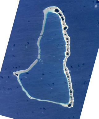
The Ninigo Islands are a group of 31 islands within the Western Islands of the Bismarck Archipelago, Papua New Guinea. Their coordinates are 1°16′S144°15′E.
The Hermit Islands are a group of 17 islands within the Western Islands of the Bismarck Archipelago, Papua New Guinea. Their coordinates are 1°30′S145°4′E.
The Kaniet Islands are the easternmost group islands within the Western Islands of the Bismarck Archipelago, Papua New Guinea. It consists four islands and one islet. Their coordinates are 0°54′S145°32′E, located north-east of the Hermit Islands. Sae Island is a nearby island often subsumed under the Kaniet(-Sae) Islands, albeit the two are distinct. Another name for the Kaniet(-Sae) Islands is "Anchorite Islands".
Micronesian outliers are some islands near New Guinea inhabited by Micronesian settlers. All of the Micronesian outliers are in the Bismarck Sea and belong to Papua New Guinea. These islands are also known under the name Western Islands
