
Rossel Island is the easternmost island of the Louisiade Archipelago, within the Milne Bay Province of Papua New Guinea. Tree Islet is situated 1.5 miles (2.4 km) to the north-west, while Wule Island is situated 1.5 miles (2.4 km) westward.
Sideia Island is an island in the Louisiade Archipelago in Milne Bay Province, Papua New Guinea.

Basilaki Island is an island in the Louisiade Archipelago in Milne Bay Province, Papua New Guinea. It is located at the eastern end of the New Guinea mainland.

Pana Tinani is an island in the Louisiade Archipelago in Milne Bay Province, Papua New Guinea.
Auriroa Island is an island in Milne Bay Province of Papua New Guinea.
Daloloia Group are islands of Papua New Guinea. They are in the Louisiade Archipelago. They Include Bonura Island and Sarupai Island. The islands have a total area of 0.13 km2
Kuwanak Island is an island in Papua New Guinea, part of the Calvados Chain within the Louisiade Archipelago. Its only settlement is called Abagagaheia, and it is located on the northwestern point. At low tide you can walk to Taifaur.
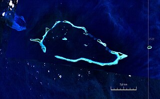
The Renard Islands are an archipelago in the Solomon Sea. Politically they belong to Milne Bay Province in the southeastern region of Papua New Guinea.

Yeina Island is an island of volcanic origin in the Southeast Louisiade Archipelago in Milne Bay Province, Papua New Guinea.

Anagusa is an island in Louisiade Archipelago, part of the Bentley Group. Politically it belongs to Milne Bay Province in the southeastern part of Papua New Guinea. For 2014 census, the island had a village of 122 residents in 21 households, although at least 1 family lives in nearby island of Nare.
The Lebrun Islands are a group of uninhabited islands in the Solomon Sea, belonging to Papua New Guinea.
The Stuers Islands are an uninhabited archipelago in the Louisiade Archipelago. Politically, they are part of Milne Bay Province in southeastern Papua New Guinea.
The Laseinie Islands are an archipelago in the Solomon Sea. Politically they belong to Bwanabwana Rural LLG of Samarai-Murua District of Milne Bay Province, in the southeastern region of Papua New Guinea. They are located southeast of the D'Entrecasteaux Islands. They are part of the Louisiade Archipelago.
The Hardman Islands are an archipelago in the Solomon Sea. Politically they belong to Bwanabwana Rural LLG of Samarai-Murua District of Milne Bay Province, in the southeastern region of Papua New Guinea. They are located southeast of the D'Entrecasteaux Islands. They are part of the Louisiade Archipelago, and are administered under The Laseinie Islands Ward.
Nimoa Island is an island in the Louisiade Archipelago in Milne Bay Province, Papua New Guinea.

Quessant is an uninhabited island in the Louisiade Archipelago. Politically, it is part of Milne Bay Province in southeastern Papua New Guinea. Quessant is located 30 km southeast of Wari on the northeastern border of the coastal reef. The coral island is low and covered with delicious vegetation. Three reefs are located between Quessant and the Stuers Islands, about 16 km to the northwest.
Dagadaga Bonarua Island is an island separating East Channel and China Strait, just south of Milne Bay, in Milne Bay Province, Papua New Guinea.
Mekinley Island is an island north of Sariba Island, and on the eastern side of China Strait, in Milne Bay Province, Papua New Guinea.
Populai Island is an island in the Louisiade Archipelago in Milne Bay Province, Papua New Guinea.
Dinana Island is an island in the Louisiade Archipelago in Milne Bay Province, Papua New Guinea.
