
The Ring of Fire is a region around much of the rim of the Pacific Ocean where many volcanic eruptions and earthquakes occur. The Ring of Fire is a horseshoe-shaped belt about 40,000 km (25,000 mi) long and up to about 500 km (310 mi) wide.

The Bismarck Archipelago is a group of islands off the northeastern coast of New Guinea in the western Pacific Ocean and is part of the Islands Region of Papua New Guinea. Its area is about 50,000 square km.

Rabaul is a township in the East New Britain province of Papua New Guinea, on the island of New Britain. It lies about 600 kilometres to the east of the island of New Guinea. Rabaul was the provincial capital and most important settlement in the province until it was destroyed in 1994 by falling ash from a volcanic eruption in its harbour. During the eruption, ash was sent thousands of metres into the air, and the subsequent rain of ash caused 80% of the buildings in Rabaul to collapse. After the eruption the capital was moved to Kokopo, about 20 kilometres (12 mi) away. Rabaul is continually threatened by volcanic activity, because it is on the edge of the Rabaul caldera, a flooded caldera of a large pyroclastic shield.

Kīlauea is an active shield volcano in the Hawaiian Islands. Located along the southeastern shore of the Big Island of Hawaiʻi, the volcano is between 210,000 and 280,000 years old and emerged above sea level about 100,000 years ago. Historically, it is the most active of the five volcanoes that together form Hawaii island. Kīlauea is also one of the most active volcanoes on Earth, and the most recent eruption began on September 29, 2021, when several vents began to erupt lava within Halemaʻumaʻu, a pit crater in the volcano's summit caldera, and ended March 7, 2023.

Sakurajima is an active stratovolcano, formerly an island and now a peninsula, in Kagoshima Prefecture in Kyushu, Japan. The lava flows of the 1914 eruption connected it with the Ōsumi Peninsula. It is the most active volcano in Japan.
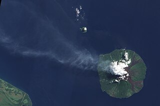
Manam, known locally as Manam Motu, is an island located in the Bismarck Sea across the Stephan Strait from Yawar on the northeast coast of mainland Papua New Guinea's Bogia District. The island is 10 kilometers wide, and was created by the activity of the Manam Volcano, one of the country’s most active. It was evacuated in 2004 and its residents resettled elsewhere in Papua New Guinea, but many have begun to return despite concerns of future volcanic activity. Manam is erupting again as of May 2022.
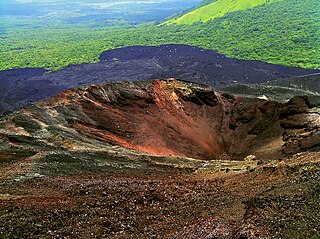
Cerro Negro is an active volcano in the Cordillera de los Maribios mountain range in Nicaragua, about 10 km (6.2 mi) from the village of Malpaisillo. It is a very new volcano, the youngest in Central America, having first appeared in April 1850. It consists of a gravelly basaltic cinder cone, which contrasts greatly with the surrounding verdant hillsides, and gives rise to its name, which means Black Hill. Cerro Negro has erupted frequently since its first eruption. One unusual aspect of several eruptions has been the emission of ash from the top of the cone, while lava erupts from fractures at the base.

Pico do Fogo is the highest peak of Cape Verde and West Africa, rising to 2,829 metres (9,281 ft) above sea level. It is an active stratovolcano lying on the island of Fogo. The main cone last erupted in 1680, causing mass emigration from the island. A subsidiary vent erupted in 1995. The only deadly eruption was in 1847 when earthquakes killed several people.

Cerro Azul, sometimes referred to as Quizapu, is an active stratovolcano in the Maule Region of central Chile, immediately south of Descabezado Grande. Part of the South Volcanic Zone of the Andes, its summit is 3,788 meters (12,428 ft) above sea level, and is capped by a summit crater that is 500 meters (1,600 ft) wide and opens to the north. Beneath the summit, the volcano features numerous scoria cones and flank vents.

Karkar Island is an oval-shaped volcanic island located in the Bismarck Sea, about 30 kilometres off the north coast of mainland Papua New Guinea in Madang Province, from which it is separated by the Isumrud Strait. The island is about 25 km in length and 19 km in width. In the centre is an active volcano with two nested calderas.

Langila is one of the most active volcanoes of New Britain, Papua New Guinea. It consists of four overlapping volcanic cones on the eastern flank of an older extinct volcano, Talawe. Talawe is the largest volcano in Cape Gloucester. There have been dozens of recorded eruptions since the 19th century from three separate volcanic craters at the summit of Langila. The most recent eruptive cycle of Langila began in August 2006 and continued into early 2007. Volcanic activity at Langila consists of Strombo-Vulcanian and Vulcanian eruptions and lava flows. Langila is one of the most active volcanoes in the Bismark archipelago. The smallest crater is crater number 3.

The Rabaul caldera, or Rabaul Volcano, is a large volcano on the tip of the Gazelle Peninsula in East New Britain, Papua New Guinea, and derives its name from the town of Rabaul inside the caldera. The caldera has many sub-vents, Tavurvur being the most well known for its devastating eruptions over Rabaul. The outer flanks of the highest peak, a 688-metre-high asymmetrical pyroclastic shield, are formed by thick pyroclastic flow deposits. There is no sign of a pyroclastic shield along the rim of the caldera, making the location likely underwater, on the caldera's floor.

Sakar Island is a volcanic island north-west of New Britain in the Bismarck Sea, at 5.416667°S 148.1°E. It is a stratovolcano with a summit crater lake. No recorded eruptions are known.
Long Island is a populated volcanic island in Madang Province, Papua New Guinea. It is located north of the island of New Guinea, separated from it by the Vitiaz Strait. The island's interior contains a 360m deep freshwater volcanic crater lake and within that lake exists an even smaller island known as Motmot island. During the late 17th or early 18th century virtually all of the biota on the island was destroyed and has subsequently provided scientists a unique opportunity to study recolonization efforts by plants, animals, and humans. The vast majority of the buildings on the island are constructed using vernacular architecture.

Bagana is an active volcanic cone located in the centre of the island of Bougainville, Papua New Guinea, the largest island of the Solomon group. It is the most active volcano in the country, occupying a remote portion of central Bougainville Island. It is one of Melanesia's youngest and most active volcanoes.

The Schouten Islands are a group of six small volcanic islands in the province of East Sepik in Papua New Guinea, north of the island of New Guinea. The group is also called Eastern Schouten Islands or Le Maire Islands to separate it from unrelated Schouten Islands in Indonesia. The combined land area is approximately 50 km2 (19 sq mi).

Kadovar is a volcanic island in Papua New Guinea northeast of the much larger island of New Guinea. The volcano erupted in January 2018 and the eruption is ongoing as of 2023, although the activity level is generally considered to be low. There were some heightened thermal phenomena in 1976.
Victory is a volcano on New Guinea island, Papua New Guinea. It is situated on Cape Nelson, 30 km from Tufi in an area with no Wadati-Benioff zone. It is one of four large stratovolcanos in Northern New Guinea island, the others being Hydrographers Range, Trafalgar and Lamington.
On the morning of March 13, 1888, an explosion took place on Ritter Island, a small volcanic island in the Bismarck and Solomon Seas, between New Britain and Umboi Island. The explosion resulted in the almost complete loss of the island and generated a tsunami with runups of up to 15 meters (49 ft) that caused damage more than 700 kilometers (430 mi) away and killed anywhere between 500 and 3,000 on neighbouring islands, including scientists and explorers. This event is the largest volcanic island sector collapse in recent history.

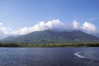
In early January 1951, a series of minor explosions and earthquakes rocked Mount Lamington, a volcano in Oro Province, Territory of Papua and New Guinea. Prior to the eruption, Mount Lamington was not recognized as a volcano due to the absence of historically-recorded eruptions and dense vegetation cover. From January 15, volcanic activity intensified, and tall eruption plumes were generated. The largest eruption occurred on the morning of January 21 when a thick black plume of ash rose 50,000 feet (15,000 m) into the atmosphere. The eruption collapsed a lava dome and produced a lethal pyroclastic flow that killed 2,942 people. In the years after the eruption, new lava domes formed and collapsed in succession. Activity persisted until July 1956. The eruption is the deadliest natural disaster in Australian history, as the region was under the rule of the Government of Australia.
