Gold was discovered on Misima late in 1888.[2] By March 1889, eighty men were on the island digging for gold, and a storekeeper had set up a business.[3]
Since 1975, Misima belongs to the independent state of Papua New Guinea. A gold and silver mine was opened on the island in 1990, by an international corporation. The mines provided plenty of work for the islanders. however, that mine was officially closed in 2004, because of excessive load on the environment and public health hazards.[4]
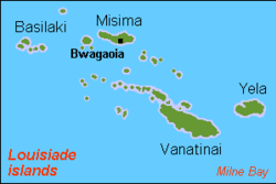
The island measures 40 by 10km (24.9 by 6.2mi) and has an area of 2,145km2 (828sqmi). It is located some 20km (12mi) north of the northwest extreme of the barrier reef of Vanatinai at Isu Raua Raua Island, and 80km (50mi) northwest of Vanatinai Island itself.
Misima is mountainous and densely forested. Mt. Koia Tau, at a height of 1,036 meters (3,399ft), is the highest peak of the Louisiade Archipelago.
It was not until 24 December 2016 when Kolbe Bare, a Papua New Guinean geologist, and two Misimans, David Kaliton and Kaliton Ada, made the first recorded ascent to the Top of Oia Tau. It was noted by Kolbe that even though the mountain is close to the sea, Higher altitude vegetation covers the top of the mountain at the time of ascent.
Climate
The local climate is tropical, moderated by northeast trade winds, with a dry season from 1 December to 31 May, and a wet season from 1 June to 30 November. it is usually very humid. Since it is fairly close to the equator, the temperature does not fluctuate much between winter and summer.
Economy
Misima island is known as a mining island. A huge mine operated many years on the island. The mine was a joint venture by Placer Dome Inc (owning 80%) and the state-owned Orogen Minerals Ltd. In March 2012 Barrick closed its post closure monitoring office in Bwagaoia having successfully rehabilitated the mine and mill sites.
Since 2004 when the mine closed, artisanal mining has become a major source of income in the island, with an association Misima Alluvial Gold Mining Association (MAGMA) starting in 2007. Other sources of income, especially for people living on the north coast, are cash crops of coconuts, copra, and cacao. A commercial fisheries project has been proposed, but has not been developed yet.
Demographics
The island has a population of 19,330, spread across 78 villages, Misima is the most heavily populated island in the Louisiade Archipelago. By area, it is the third largest, after Vanatinai and Rossel Island. Since the mines have closed, there are signs of population decrease. people are moving to Alotau for jobs.
Urbanization
The main town of the island and the seat of the district is Bwagaoia, located on the southeast corner of the island. Other villages are Hinauta, Boiou, Gulewa, Bagilina, Liak, Siagara, Eiaus (on the eastern north coast, reachable by road from Bwagaoia), Gulewa and Ewena (on the western north coast), and Bwagabwaga, Gaibobo and Alhoga (on the south coast).[5]
↑ Nelson, Hank (1976) Black, white & gold: goldmining in Papua New Guinea, 1878-1930, Canberra, Australian National University Press, p.28. ISBN0708104878
This page is based on this Wikipedia article Text is available under the CC BY-SA 4.0 license; additional terms may apply. Images, videos and audio are available under their respective licenses.


