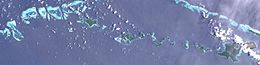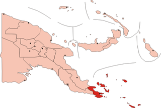
The Louisiade Archipelago is a string of ten larger volcanic islands frequently fringed by coral reefs, and 90 smaller coral islands in Papua New Guinea.
Hemenahei Island is an island in Papua New Guinea, part of the Calvados Chain within the Louisiade Archipelago. It is located to toward the eastern end of the Calvados Chain, in the Louisiade Archipelago, in the Milne Bay Province, between Pana Tinani in the East and Pana Wina in the West.

Pana Tinani is an island in the Louisiade Archipelago in Milne Bay Province, Papua New Guinea.

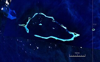
The Deboyne Islands are an atoll, composed of a group of reefs and islands in the north of the Louisiade Archipelago, Papua New Guinea.
Auriroa Island is an island in Milne Bay Province of Papua New Guinea.
Bagaman Island is an island of Papua New Guinea, part of the Calvados Chain within the Louisiade Archipelago. Misima language is the native language on the island.
The Calvados Chain are a group of islands in the Solomon Sea, belonging to Papua New Guinea within the Louisiade Archipelago.
Kuwanak Island is an island in Papua New Guinea, part of the Calvados Chain within the Louisiade Archipelago. Its only settlement is called Abagagaheia, and it is located on the northwestern point. At low tide you can walk to Taifaur.
Pana Wina Island is an island of Papua New Guinea. It is part of the Calvados Chain, a grouping of islands within the Louisiade Archipelago. Pana Wina is the largest island in the Calvados Chain, and lies near the eastern end of the chain, just west of Hemenahei Island. The very small Yakimoan Island lies just west of Pana Wina. The capital village of the Calvados Chain, where the ward's school is located, Bomalou, with a population of just over 300, lies on the western shore of the island.
The Sloss Islands are an uninhabited archipelago in Louisiade Archipelago.
Panatanian Island is an island in Papua New Guinea, part of the Calvados Chain within the Louisiade Archipelago. It is located between Panangaribu and Panakrusima islands. It should not be confused with Pana Tinani, which is a different island in the east.
Panasia Island is an island in Papua New Guinea, part of the Calvados Chain within the Louisiade Archipelago. It is located at the western end of the Calvados Chain, in the Louisiade Archipelago, in the Milne Bay Province, next to Pana Varavara. Utian islanders use this island for gardening yams.
Pana Numara Island is an island in Papua New Guinea, part of the Calvados Chain within the Louisiade Archipelago. It is located at the middle of the Calvados Chain, in the Louisiade Archipelago, in the Milne Bay Province.
Sabari Island is an island in Papua New Guinea, part of the Calvados Chain within the Louisiade Archipelago. Politically, it is in its own separate Ward, not like the other Calvados Chain islands which all belong to the Calvados Chain Ward. It is located at a reef called Tawa Tawamal . It is the most populated island of the group. The main villages are Hekampen, Tandeyai, Hebenahine, and Maho.
Bobo Eina Island is an island in Papua New Guinea, part of the Calvados Chain within the Louisiade Archipelago. It is located near Bagaman Island. It is used as a fishermen camp for the men of Bagaman. In recent years, Bagaman islanders use Bobo Eina for gardening yams, and have also established a pig farm on the island.
Nigaho Island is an island in Papua New Guinea, part of the Calvados Chain within the Louisiade Archipelago. Politically, it is in Pana Tinani Ward, not like the other Calvados Chain islands which all belong to the Calvados Chain Ward. It is the most densely populated island of the chain. It is the most eastern island of the chain.
Gilia Island is an island in Papua New Guinea, part of the Calvados Chain within the Louisiade Archipelago. It is located near Bagaman Island. It is used as a coconut camp for the men of Bagaman. In recent years, Bagaman islanders use Gilia for claiming coconuts.
Gulewa Island is an island in Papua New Guinea, part of the Calvados Chain within the Louisiade Archipelago. It is located near Utian Island. It is used as a gardening island for the Utian Islanders.
Pana Rora Island is an island in Papua New Guinea, part of the Calvados Chain within the Louisiade Archipelago. It is located near Utian Island. It is used as a gardening island for the Utian Islanders.
Venariwa Island is an island in Papua New Guinea, part of the Calvados Chain within the Louisiade Archipelago. It is located near Utian Island. It is used as a gardening island for the Utian Islanders.