
The Tasman Sea is a marginal sea of the South Pacific Ocean, situated between Australia and New Zealand. It measures about 2,000 km (1,200 mi) across and about 2,800 km (1,700 mi) from north to south. The sea was named after the Dutch explorer Abel Janszoon Tasman, who in 1642 was the first known person to cross it. British explorer Lieutenant James Cook later extensively navigated the Tasman Sea in the 1770s during his three voyages of exploration.

The Arctic Archipelago, also known as the Canadian Arctic Archipelago, is an archipelago lying to the north of the Canadian continental mainland, excluding Greenland and Iceland.

The Bismarck Archipelago is a group of islands off the northeastern coast of New Guinea in the western Pacific Ocean and is part of the Islands Region of Papua New Guinea. Its area is about 50,000 square km.

The Savu Sea is a small sea within Indonesia named for the island of Savu (Sawu) on its southern boundary. It is bounded by Savu and Rai Jua to the south, the islands of Rote and Timor to the east, Flores and the Alor archipelago to the north/northwest, and the island of Sumba to the west/northwest. Between these islands, it flows into the Indian Ocean to the south and west, the Flores Sea to the north, and the Banda Sea to the northeast.

The Kodiak Archipelago is an archipelago south of the main land-mass of the state of Alaska, about 405 km (252 mi) by air south-west of Anchorage in the Gulf of Alaska. The largest island in the archipelago is Kodiak Island, the second-largest island in the United States. The archipelago has a length of about 285 km (177 mi) and a width of about 108 km (67 mi), from the Barren Islands on the north to Chirikof Island and the Semidi Islands group on the south. The archipelago contains 13,890 km2 (5,360 sq mi) of land. The Kodiak Archipelago contains about 40 small glaciers, numerous streams and many species of land and marine animals. Much of its land is forested.

The Flores Sea covers 240,000 square kilometres (93,000 sq mi) of water in Indonesia. The sea is bounded on the north by the island of Celebes and on the south by Sunda Islands of Flores and Sumbawa.

The Green Islands is a small archipelago of islands in the Solomon Sea, within the Autonomous Region of Bougainville, in northeastern Papua New Guinea.

Nissan Island is the largest of the Green Islands of Papua New Guinea. It is located at 4°30′S154°13′E, about 200 km east of Rabaul on New Britain and about 200 km north-west of Bougainville. The island is administered under Nissan Rural LLG in the Autonomous Region of Bougainville. Nissan island, along with other nearby islands, has been described as a "stepping stone island" and it is believed that this island plays an important role in helping various plant and animal species spread throughout the region.
Ross Archipelago is a name for that group of islands which, together with the ice shelf between them, forms the eastern and southern boundaries of McMurdo Sound in Antarctica. The most northerly is Beaufort Island, then comes Ross Island, the Dellbridge Islands, and Black Island and White Island. Frank Debenham's classic report, The Physiography of the Ross Archipelago, 1923, described "Brown Island" as a part of the group.

Mariner Glacier is a major glacier over 100 km (62 mi) long, descending southeast from the plateau of Victoria Land, between Mountaineer Range and Malta Plateau, and terminating at Lady Newnes Bay, Ross Sea, where it forms the floating Mariner Glacier Tongue. Its lower reaches and entrance to its valley were reconnoitered in December 1958 by Captain John Cadwalader, US Navy, and two members of New Zealand Geological Survey Antarctic Expedition (NZGSAE), in a flight from the icebreakers USS Glacier and USS Staten Island which were lying close off the south end of Coulman Island, in an attempt to land expedition members on the mainland. Named by NZGSAE, 1958–59, as a tribute to the work of mariners in Antarctic research and exploration.
Isolation Point is a small volcanic peak projecting through the ice sheet covering the southeastern extremity of White Island, in the Ross Archipelago, Antarctica. It was so named because of its remote position by the New Zealand Geological Survey Antarctic Expedition, 1958–59.

The borders of the oceans are the limits of Earth's oceanic waters. The definition and number of oceans can vary depending on the adopted criteria. The principal divisions of the five oceans are the Pacific Ocean, Atlantic Ocean, Indian Ocean, Southern (Antarctic) Ocean, and Arctic Ocean. Smaller regions of the oceans are called seas, gulfs, bays, straits, and other terms. Geologically, an ocean is an area of oceanic crust covered by water.
The Tudjuh Archipelago is a large group of islands in north-western Indonesia, off the west and north-west coast of the island of Borneo in the South China Sea. Administratively the islands belong to the Riau Islands province of Indonesia. The Tudjuh Archipelago consists of four island groups, the Badas Islands, the Tambelan Islands, the Natuna Islands, and the Anambas Islands. The south-westernmost extent of the archipelago is 1°4′S105°10′E.
Hidaybu District is one of two districts of the Socotra Governorate, Yemen. It occupies the eastern part of the main island of Socotra archipelago. It is named after its capital and the principal town of the archipelago, the town of Hidaybu (Hadibu). As of 2003, the district had a population of 34,011 people.
Pinipel Island, also known as Green Island, is the northern of the two atolls making up the Green Islands, east of New Ireland, Papua New Guinea. It is located north of Nissan Island, the southern atoll. It is about 330 feet (101 m) high and cliffy, from 200 to 500 yards wide, except at the north end.
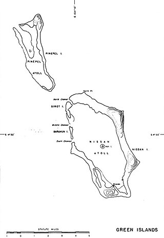
Sirot Island is an island of Papua New Guinea, located in the Green Islands, east of New Ireland. It is located of the north-west coast of Nissan Island, north of Barahun Island. It is 1.25 miles (2.01 km) long.
The Tarava Seamounts are a group of seamounts in the southern Pacific Ocean, southwest of the Society Islands. They are formed by five guyots and a number of cone-shaped seamounts. Of Eocene-Oligocene age, they may have formed under the influence of a hotspot.
Tahua is a Duff Islands archipelago, located in the Temotu Province of the Solomon Islands in the Pacific Ocean. The estimated terrain elevation above sea level is some 23 metres. The island is inhabited.

