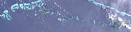
Calvados Chain

Last updated
Calvados Chain
Calvados Chain (Landsat).JPG
Satellite image
Papua New Guinea location map.svg
Red pog.svg
Calvados Chain
Geography
Location Oceania
Coordinates 11°09′48″S152°48′32″E / 11.16333°S 152.80889°E / -11.16333; 152.80889 Coordinates: 11°09′48″S152°48′32″E / 11.16333°S 152.80889°E / -11.16333; 152.80889 [1]
Archipelago Louisiade Archipelago
Adjacent to Solomon Sea
Total islands45
Major islands
Area85.1 km2 (32.9 sq mi)
Administration
Province Flag of Milne Bay.svg  Milne Bay
District Samarai-Murua District
LLG [2] multiple
Island Group Calvados Chain
Largest settlement Bomalou (pop. 300)
Demographics
Population3276 (2014)
Ethnic groups Papauans, Austronesians, Melanesians.
Additional information
Time zone
ISO code PG-MBA
Official website www.ncdc.gov.pg

The Calvados Chain are a group of islands in the Solomon Sea, belonging to Papua New Guinea within the Louisiade Archipelago.

Contents

Geography

The group extends from Pana Varavara in the west to the small island of Nigaho in the east over a distance of 88 km. The easternmost island of Nigaho is where the chain of islands end. Pana Tinani is separated from the group by the isolated Magamaga Channel. The islands rise up to 302 meters (Motorina) steeply from the sea and are either wooded or overgrown with grass. Many islands are surrounded by their own reefs and small lagoons. Apart from the high islands, there are numerous low coral islands and reefs. The eastern edge of the chain lies to the northwest of Vanatinai (formerly Sudest) Island. [3]

Population

Twelve of the islands are inhabited, with a total of 3276 residents as of 2014. The islanders speak the Misima-Paneati Language.

Islands

Primary islands in the chain:

IslandCapitalOther CitiesArea
km²
Population
2014
Pana Varavara 0.570
Panasia 2.110
Sloss Islands 0.360
Utian Utian 1.54514
Pana Rora 0.810
Pana Udu Udi 0.690
Gulewa Gulewa 0.5918
Ululina Ululina 0.595
Venariwa Venariwa 0.7616
Motorina Riman Bay Tawara, Mabaraboraboa 7.8595
Bonna Wan 1.090
Bagaman Bagaman 7.45264
Bobo Eina 2.430
Pana Numara Hoba Bay 1.93183
Yaruman 0.370
Panangaribu 0.50
Panatinane 0.790
Pana Krusima 1.470
Kuwanak Kuwanak 3.66170
Gigila Nogui 1.42121
Pana Wina Bomalou Panambari, Boiama 30.55456
Hemenahei 10.150
Nigao Nigao 0.1226
Sabari Hekampan Tandeyai, Hebenahine, Maho 4.04708
Calvados Chain Pana Wina Motorina, Bagaman 85.13276

[4]

Related Research Articles

<span class="mw-page-title-main">Milne Bay Province</span> Place in Papua New Guinea

Milne Bay is a province of Papua New Guinea. Its capital is Alotau. The province covers 14,345 km² of land and 252,990 km² of sea, within the province there are more than 600 islands, about 160 of which are inhabited. The province has about 276,000 inhabitants, speaking about 48 languages, most of which belong to the Eastern Malayo-Polynesian branch of the Austronesian language family. Economically the province is dependent upon tourism, oil palm, and gold mining on Misima Island; in addition to these larger industries there are many small-scale village projects in cocoa and copra cultivation. The World War II Battle of Milne Bay took place in the province.

<span class="mw-page-title-main">Carteret Islands</span> Papua New Guinea islands in located in northeast of Bougainville in the South Pacific

The Carteret Islands are Papua New Guinea islands located 86 km (53 mi) north-east of Bougainville in the South Pacific. The atoll has a scattering of low-lying islands called Han, Jangain, Yesila, Yolasa and Piul, in a horseshoe shape stretching 30 km (19 mi) in north-south direction, with a total land area of 0.6 square kilometres (0.2 sq mi) and a maximum elevation of 1.5 metres above sea level.

Hemenahei Island is an island in Papua New Guinea, part of the Calvados Chain within the Louisiade Archipelago. It is located to toward the eastern end of the Calvados Chain, in the Louisiade Archipelago, in the Milne Bay Province, between Pana Tinani in the East and Pana Wina in the West.

<span class="mw-page-title-main">Pana Tinani</span>

Pana Tinani is an island in the Louisiade Archipelago in Milne Bay Province, Papua New Guinea.

<span class="mw-page-title-main">Deboyne Islands</span>

The Deboyne Islands are an atoll, composed of a group of reefs and islands in the north of the Louisiade Archipelago, Papua New Guinea.

<span class="mw-page-title-main">Duchateau Islands</span>

The Duchateau Islands are an island group in the Coral Sea, belonging to Papua New Guinea. They lie to the east of Panarairai Island in the Louisiade Archipelago.

The Renard Islands are an archipelago in the Solomon Sea. Politically they belong to Milne Bay Province in the southeastern region of Papua New Guinea.

Pana Wina Island is an island of Papua New Guinea. It is part of the Calvados Chain, a grouping of islands within the Louisiade Archipelago. Pana Wina is the largest island in the Calvados Chain, and lies near the eastern end of the chain, just west of Hemenahei Island. The very small Yakimoan Island lies just west of Pana Wina. The capital village of the Calvados Chain, where the ward's school is located, Bomalou, with a population of just over 300, lies on the western shore of the island.

<span class="mw-page-title-main">Strathord Islands</span>

The Strathord Islands are an uninhabited island group of five islands in the Louisiade Archipelago of Papua New Guinea. Politically they belong to the province of Milne Bay in the southeastern region of Papua New Guinea.

Utian Island, also known as Brooker Island, is an island in Papua New Guinea, part of the Calvados Chain within the Louisiade Archipelago. It is located at the western end of the Calvados Chain, in the Louisiade Archipelago, in the Milne Bay Province.

<span class="mw-page-title-main">Yeina Island</span>

Yeina Island is an island of volcanic origin in the Southeast Louisiade Archipelago in Milne Bay Province, Papua New Guinea.

<span class="mw-page-title-main">Jomard Islands</span>

The Jomard Islands are an uninhabited island group in the Coral Sea, belonging to Papua New Guinea, It lies to the east of Montemont Islands in the Louisiade Archipelago.

The Sloss Islands are an uninhabited archipelago in Louisiade Archipelago.

Panasia Island is an island in Papua New Guinea, part of the Calvados Chain within the Louisiade Archipelago. It is located at the western end of the Calvados Chain, in the Louisiade Archipelago, in the Milne Bay Province, next to Pana Varavara. Utian islanders use this island for gardening yams.

Pana Numara Island is an island in Papua New Guinea, part of the Calvados Chain within the Louisiade Archipelago. It is located at the middle of the Calvados Chain, in the Louisiade Archipelago, in the Milne Bay Province.

Sabari Island is an island in Papua New Guinea, part of the Calvados Chain within the Louisiade Archipelago. Politically, it is in its own separate Ward, not like the other Calvados Chain islands which all belong to the Calvados Chain Ward. It is located at a reef called Tawa Tawamal . It is the most populated island of the group. The main villages are Hekampen, Tandeyai, Hebenahine, and Maho.

Nigaho Island is an island in Papua New Guinea, part of the Calvados Chain within the Louisiade Archipelago. Politically, it is in Pana Tinani Ward, not like the other Calvados Chain islands which all belong to the Calvados Chain Ward. It is the most densely populated island of the chain. It is the most eastern island of the chain.

<span class="mw-page-title-main">Wari Island</span>

Wari Island is an island in the southwest of the Louisiade Archipelago. Politically it belongs to Milne Bay Province in the southeastern part of Papua New Guinea.

Pana Rora Island is an island in Papua New Guinea, part of the Calvados Chain within the Louisiade Archipelago. It is located near Utian Island. It is used as a gardening island for the Utian Islanders.

References

  1. Prostar Sailing Directions 2004 New Guinea Enroute, p. 168
  2. "LLG map" (PDF). Archived from the original (PDF) on 2010-08-11. Retrieved 2016-03-10.
  3. The Kula: New Perspectives on Massim Exchange, pp. 469-70 (1983)
  4. Calvados Chain, oceandots.com (1999)(archive.com)