The Battle of the Coral Sea, from 4 to 8 May 1942, was a major naval battle between the Imperial Japanese Navy (IJN) and naval and air forces of the United States and Australia. Taking place in the Pacific Theatre of World War II, the battle was the first naval action in which the opposing fleets neither sighted nor fired upon one another, attacking over the horizon from aircraft carriers instead.
The Louisiade Archipelago is a string of ten larger volcanic islands frequently fringed by coral reefs, and 90 smaller coral islands in Papua New Guinea.

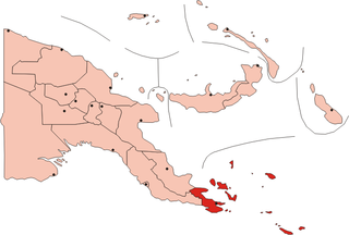
Milne Bay is a province of Papua New Guinea. Its capital is Alotau. The province covers 14,345 km² of land and 252,990 km² of sea, within the province there are more than 600 islands, about 160 of which are inhabited. The province has about 276,000 inhabitants, speaking about 48 languages, most of which belong to the Eastern Malayo-Polynesian branch of the Austronesian language family. Economically the province is dependent upon tourism, oil palm, and gold mining on Misima Island; in addition to these larger industries there are many small-scale village projects in cocoa and copra cultivation. The World War II Battle of Milne Bay took place in the province.
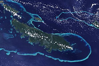
Vanatinai Island is a volcanic island in the south-east of the Louisiade Archipelago within Milne Bay Province of Papua New Guinea. The reef-fringed island is approximately 360 kilometres south-east of New Guinea and 30 kilometres south of Misima. With an area of 830 square kilometres, it is the largest island of the archipelago. Tagula town, the main settlement, is located on the north-west coast. The population was 3628 as of 2014. The principal export is copra.
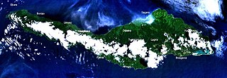
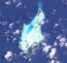
Misima is a volcanic island in the northwest of Louisiade Archipelago within Milne Bay Province of Papua New Guinea.
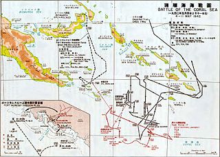
Operation Mo or the Port Moresby Operation was a Japanese plan to take control of the Australian Territory of New Guinea during World War II as well as other locations in the South Pacific. The goal was to isolate Australia and New Zealand from the Allied United States.
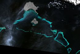
A series of raids on Deboyne were conducted by Allied forces against the Imperial Japanese Navy seaplane base in the Deboyne Islands of the Louisiade Archipelago between 9–11 May 1942. The seaplane base had been set up prior to the Battle of Coral Sea and became untenable and was abandoned by the Japanese, due to proximity to Allied airfields at Port Moresby and the failure of Mo Sakusen.
Sideia Island is an island in the Louisiade Archipelago in Milne Bay Province, Papua New Guinea.

The Panniet naked-backed fruit bat, also known as the De Vis's Bare-backed Fruit Bat and Panaeati Bare-backed Fruit Bat, is a species of megabat in the family Pteropodidae. It roosts in groups, within caves and tree hollows.
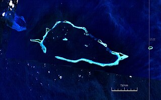
The Conflict Group is an atoll in Papua New Guinea. The group was sighted in 1879 by HMS Cormorant, by moonlight; it was named in 1880 by Bower, captain of HMS Conflict. Irai Island is the center of population of the group.
Bagaman Island is an island of Papua New Guinea, part of the Calvados Chain within the Louisiade Archipelago. Misima language is the native language on the island.
The Calvados Chain are a group of islands in the Solomon Sea, belonging to Papua New Guinea within the Louisiade Archipelago.
The Renard Islands are an archipelago in the Solomon Sea. Politically they belong to Milne Bay Province in the southeastern region of Papua New Guinea.
The Strathord Islands are an uninhabited island group of five islands in the Louisiade Archipelago of Papua New Guinea. Politically they belong to the province of Milne Bay in the southeastern region of Papua New Guinea.

Bramble Haven is an atoll in the Louisiade Archipelago. Its islands on the northern section are grouped as the Duperre Islands.

The Engineer Islands are an archipelago in the Solomon Sea belonging to Papua New-Guinea.

The Torlesse Islands are an archipelago in the Solomon Sea. Politically they belong to Milne Bay Province in the southeastern region of Papua New Guinea. They are 13 km away from Misima and 5 km west of Deboyne Islands. The aggregate land area of the seven islands is 2.08 km2. The main village is Tinolan. it is inhabited by a family from Panaeati Island who grow Copra.

The Samarai Islands archipelago, part of the larger Louisiade Archipelago, is located 50 kilometres (31 mi) southeast of mainland New Guinea island, within the nation of Papua New Guinea.
The Louisiade Rural LLG is a local level government in the Milne Bay Province of Papua New Guinea. The LLG is situated in the Louisiade Archipelago. At the 2011 census, it contained 23,335 residents living in 4,542 households. The LLG president is Benjamin Kuli. It launched its own microfinance scheme in December 2016.