
Weather forecasting is the application of science and technology to predict the conditions of the atmosphere for a given location and time. People have attempted to predict the weather informally for millennia and formally since the 19th century.

The Meteorological Office, abbreviated as the Met Office, is the United Kingdom's national weather and climate service. It is an executive agency and trading fund of the Department for Science, Innovation and Technology and is led by CEO Penelope Endersby, who took on the role as Chief Executive in December 2018 and is the first woman to do so. The Met Office makes meteorological predictions across all timescales from weather forecasts to climate change.

The Fleet Numerical Meteorology and Oceanography Center (FNMOC) is an echelon IV component of the Naval Meteorology and Oceanography Command (NMOC), which provides worldwide meteorological and oceanographic data and analysis for the United States Navy and strategic allies of the United States. The center is based out of Monterey, California. FNMOC provides Global and Regional Weather Prediction Charts (WXMAP) and Global Ensemble Weather Prediction Charts (EFS). WxMAP depictions of NAVGEM predictions for side-by-side comparison with NCEP global NWS models (GFS) are also available. FNMOC provides Global and Regional Ocean Wave Prediction Charts (WW3), Global Ensemble Ocean Wave Prediction Charts, and Global Sea Surface Temperature and Sea Surface Anomaly Charts (NCODA). FNMOC provides links to satellite imagery of tropical cyclones (TCWEB) and current tropical storm forecast tracks.
HIRLAM, the High Resolution Limited Area Model, is a Numerical Weather Prediction (NWP) forecast system developed by the international HIRLAM programme.
The United States Marine Modeling and Analysis Branch (MMAB) is part of the Environmental Modeling Center, which is responsible for the development of improved numerical weather and marine prediction modeling systems within NCEP/NWS. It provides analysis and real-time forecast guidance on marine meteorological, oceanographic, and cryospheric parameters over the global oceans and coastal areas of the US.

The NASA QuikSCAT was an Earth observation satellite carrying the SeaWinds scatterometer. Its primary mission was to measure the surface wind speed and direction over the ice-free global oceans via its effect on water waves. Observations from QuikSCAT had a wide array of applications, and contributed to climatological studies, weather forecasting, meteorology, oceanographic research, marine safety, commercial fishing, tracking large icebergs, and studies of land and sea ice, among others. This SeaWinds scatterometer is referred to as the QuikSCAT scatterometer to distinguish it from the nearly identical SeaWinds scatterometer flown on the ADEOS-2 satellite.
Meteorological Service of New Zealand Limited (MetService) (Māori: Te Ratonga Tirorangi, lit. 'Satellite Service') is the national meteorological service of New Zealand. MetService was established as a state-owned enterprise in 1992. It employs about 300 staff, and its headquarters are in Wellington, New Zealand. Prior to becoming a state-owned enterprise, New Zealand's national meteorological service has existed in a number of forms since the appointment of the country's first Director of Meteorological Stations in August 1861.

The Royal Netherlands Meteorological Institute is the Dutch national weather forecasting service, which has its headquarters in De Bilt, in the province of Utrecht, central Netherlands.

The Danish Meteorological Institute is the official Danish meteorological institute, administrated by the Ministry of Climate, Energy and Utilities. It makes weather forecasts and observations for Denmark, Greenland, and the Faroe Islands.
In physical oceanography, the significant wave height (SWH, HTSGW or Hs) is defined traditionally as the mean wave height (trough to crest) of the highest third of the waves (H1/3). It is usually defined as four times the standard deviation of the surface elevation – or equivalently as four times the square root of the zeroth-order moment (area) of the wave spectrum. The symbol Hm0 is usually used for that latter definition. The significant wave height (Hs) may thus refer to Hm0 or H1/3; the difference in magnitude between the two definitions is only a few percent. SWH is used to characterize sea state, including winds and swell.

The former Proudman Oceanographic Laboratory (POL) is based in Brownlow Street, Liverpool, England. In April 2010, POL merged with the National Oceanography Centre, Southampton (NOCS) to form the National Oceanography Centre. The Liverpool laboratory's scientific research focuses on oceanography encompassing global sea-levels and geodesy, numerical modelling of continental shelf seas and coastal sediment processes. This research alongside activities of surveying, monitoring, data management and forecasting provides strategic support for the wider mission of the Natural Environment Research Council.
TAMDAR is a weather monitoring system that consists of an in situ atmospheric sensor mounted on commercial aircraft for data gathering. It collects information similar to that collected by radiosondes carried aloft by weather balloons. It was developed by AirDat LLC, which was acquired by Panasonic Avionics Corporation in April 2013 and was operated until October 2018 under the name Panasonic Weather Solutions. It is now owned by FLYHT Aerospace Solutions Ltd.
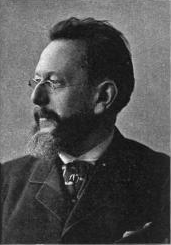
Henrik Mohn was a Norwegian astronomer and meteorologist. Although he enrolled in theology studies after finishing school, he is credited with founding meteorological research in Norway, being a professor at the Royal Frederick University and director of the Norwegian Meteorological Institute from 1866 to 1913.
The Unified Model is a numerical weather prediction and climate modeling software suite originally developed by the United Kingdom Met Office from 1990, and now both used and further developed by many weather-forecasting agencies around the world. The Unified Model gets its name because a single model is used across a range of both timescales and spatial scales. The models are grid-point based, rather than wave based, and are run on a variety of supercomputers around the world. The Unified Model atmosphere can be coupled to a number of ocean models. At the Met Office it is used for the main suite of Global Model, North Atlantic and Europe model (NAE) and a high-resolution UK model (UKV), in addition to a variety of Crisis Area Models and other models that can be run on demand. Similar Unified Model suites with global and regional domains are used by many other national or military weather agencies around the world for operational forecasting.

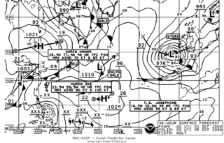
The Ocean Prediction Center (OPC), established in 1995, is one of the National Centers for Environmental Prediction's (NCEP's) original six service centers. Until 2003, the name of the organization was the Marine Prediction Center. Its origins are traced back to the sinking of the RMS Titanic in 1912. The OPC issues forecasts up to five days in advance for ocean areas north of 31° north latitude and west of 35° west longitude in the Atlantic, and across the northeast Pacific north of 30° north latitude and east of 160° east longitude. Until recently, the OPC provided forecast points for tropical cyclones north of 20° north latitude and east of the 60° west longitude to the National Hurricane Center. OPC is composed of two branches: the Ocean Forecast Branch and the Ocean Applications Branch.
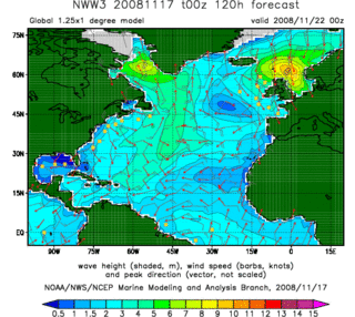
In fluid dynamics, wind wave modeling describes the effort to depict the sea state and predict the evolution of the energy of wind waves using numerical techniques. These simulations consider atmospheric wind forcing, nonlinear wave interactions, and frictional dissipation, and they output statistics describing wave heights, periods, and propagation directions for regional seas or global oceans. Such wave hindcasts and wave forecasts are extremely important for commercial interests on the high seas. For example, the shipping industry requires guidance for operational planning and tactical seakeeping purposes.

yr.no is a Norwegian website and a mobile app for weather forecasting and dissemination of other types of meteorological information hosted by the Norwegian Broadcasting Corporation in collaboration with the Norwegian Meteorological Institute. The website was launched in September 2007.

STANAG 6022 – Adoption of a Standard Gridded Data Meteorological Message is a NATO Standardization Agreement for gridded meteorological data for operational use in Artillery fire control systems, NBC Automated Warning, Reporting and Prediction Systems, and various computer-based Battlefield Decision Aids (BDAs). The message format is referred to as METGM.
Marine weather forecasting is the process by which mariners and meteorological organizations attempt to forecast future weather conditions over the Earth's oceans. Mariners have had rules of thumb regarding the navigation around tropical cyclones for many years, dividing a storm into halves and sailing through the normally weaker and more navigable half of their circulation. Marine weather forecasts by various weather organizations can be traced back to the sinking of the Royal Charter in 1859 and the RMS Titanic in 1912.
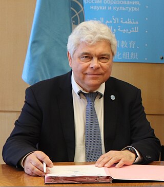
Vladimir Ryabinin, born 23 May 1956 in the city of Korolev in the Moscow Oblast, Russia, is a Russian oceanographer, climatologist, and meteorologist. On 1 March 2015 he became the Executive Secretary of the Intergovernmental Oceanographic Commission (IOC) of UNESCO and Assistant Director General of UNESCO.

