Related Research Articles

Aracaju is the capital of the state of Sergipe, Brazil, located in the northeastern part of the country on the coast, about 350 km (217 mi) north of Salvador. According to the 2020 estimate, the city has 664,908 inhabitants, which represents approximately 33% of the state population. Adding to the populations of the municipalities forming the Metropolitan area: Barra dos Coqueiros, Nossa Senhora do Socorro and São Cristóvão. Its Metropolitan Cathedral Nossa Senhora da Conceiçao, dedicated to Our Lady of Immaculate Conception, is the archiepiscopal see of the Roman Catholic Archdiocese of Aracaju.

São Luís is the capital and largest city of the Brazilian state of Maranhão. The city is located on Upaon-açu Island or Ilha de São Luís, in the Baía de São Marcos, an extension of the Atlantic Ocean which forms the estuary of Pindaré, Mearim, Itapecuru and other rivers. Its coordinates are 2.53° south, 44.30° west. São Luís has the second largest maritime extension within Brazilian states. Its maritime extension is 640 km. The city proper has a population of some 1,037,775 people. The metropolitan area totals 1,536,017, ranked as the 15th largest in Brazil.

Belém, often called Belém of Pará, is the capital and largest city of the state of Pará in the north of Brazil. It is the gateway to the Amazon River with a busy port, airport, and bus/coach station. Belém lies approximately 100 km upriver from the Atlantic Ocean, on the Pará River, which is part of the greater Amazon River system, separated from the larger part of the Amazon delta by Ilha de Marajó. With an estimated population of 1,303,403 people — or 2,491,052, considering its metropolitan area — it is the 12th most populous city in Brazil, as well as the 16th by economic relevance. It is the second largest in the North Region, second only to Manaus, in the state of Amazonas.
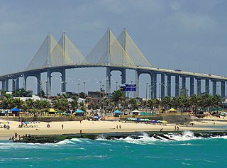
Natal is the capital and largest city of the state of Rio Grande do Norte, located in northeastern Brazil. According to IBGE's 2022 estimate, the city had a total population of 751,300, making it the 24th largest city in the country. Natal is a major tourist destination and an exporting hub of crustaceans, carnauba wax and fruits, mostly melon, sugar apple, cashew and papaya. Natal is Brazil's closest city to Africa and Europe, its Greater Natal International Airport connects the city with many Brazilian destinations and also operates some international flights. The city was one of the host cities of the 2014 FIFA World Cup.

Maceió, formerly sometimes Anglicised as Maceio, is the capital and the largest city of the coastal state of Alagoas, Brazil. The name "Maceió" is an Indigenous term for a spring.
Campos do Jordão is a municipality in the state of São Paulo in southeastern Brazil. It is part of the Metropolitan Region of Vale do Paraíba e Litoral Norte. The population is 52,405 in an area of 290.52 square kilometres (112.17 sq mi). The city is situated 1,628 metres (5,341 ft) above sea level and is the highest city in Brazil.

Franca is a municipality in the state of São Paulo, Brazil. The city is located in the northeastern portion of the state, distant 401 km from the state capital São Paulo, and 676 km from Brasilia. It covers a total area of 605,679 km2 of which 86,92 km2 comprises the urban area. As of the 2022 Census, the city's population was 352,537.
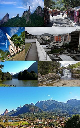
Teresópolis is a Brazilian municipality located in the state of Rio de Janeiro, in a mountainous region known as Região Serrana. The Serra dos Órgãos National Park lies partly within the city limits. The city is known as the home of the Brazil national football team, since it hosts CBF's training ground at Granja Comary.

Corumbá is a municipality in the Brazilian state of Mato Grosso do Sul, 425 km northwest of Campo Grande, the state's capital. It has a population of approximately 112,000 inhabitants, and its economy is based mainly on agriculture, animal husbandry, mineral extraction, and tourism, being the gateway to the biggest wetlands of the world, the Pantanal. Due to its border with Bolivia, Bolivians in Brazil constitute a significant portion of the city's population, forming a distinct cultural community. The city is served by Corumbá International Airport.

Arapiraca is a Brazilian municipality in the state of Alagoas, Northeast Region of the country. It is located in Agreste in Alagoas and belongs to the Metropolitan Region of Agreste, being located about 125 km (78 mi) west of state capital. It occupies an area of just over 345 km2 (133 sq mi), being 59 km2 (23 sq mi) in urban area, and its population in 2021 was 234,309 inhabitants. Being the second municipality with the largest population in Alagoas and the ninth in the interior of the Northeast.
Passo Fundo is a municipality in the north of the southern Brazilian state of Rio Grande do Sul. It is named after its river. It's the tenth largest city in the state with an estimated population of 204,722 inhabitants living in a total municipal area of 780 km2.

Campos dos Goytacazes is a municipality located in the northern region of Rio de Janeiro State, Brazil, with a population of 483,540 inhabitants.
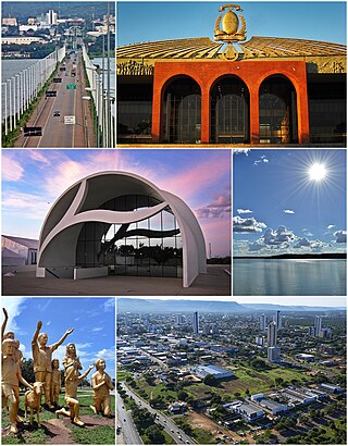
Palmas is the capital and largest city of the state of Tocantins, Brazil. According to IBGE estimates from 2020, the city had 306,296 inhabitants. Palmas has a metropolitan area with 471,639 inhabitants.

Unaí is a municipality in the Northern Region of Minas Gerais, in the Brazilian state of Minas Gerais, in the Southeast Region of Brazil. It is located 590 km from the capital of Minas Gerais and 164 km from the federal capital. Unaí is the main municipality of its micro-region of the same name and, together with Paracatu, the most important city of the said mesoregion of Minas Gerais. Due to its geopolitical location, because it is geographically and politically linked to Brasilia and politically to Belo Horizonte, the municipality has a strong economic dynamism for a municipality that still carries the typically mineiro custom.

The climate in Brazil varies considerably from mostly tropical north to temperate zones south of the Tropic of Capricorn.

Almost all of Uruguay has a humid subtropical climate. It is fairly uniform nationwide, since the country is located entirely within the temperate zone. Seasonal variations do exist, but extremes in temperature are rare. As would be expected by its abundance of water, high humidity and fog are common. The absence of mountains and other weather barriers makes all locations vulnerable to high winds and rapid changes in weather as fronts or storms sweep across the country.

São Joaquim is a municipality in the state of Santa Catarina, situated in southern Brazil. Its population in 2020 was 27,139 inhabitants. Located in the Planalto Serrano, it lies 136 km from Tubarão, 81 km from Lages and 227 km from Florianópolis. The town is home to a variety of ethnic groups, including Italian, German, Portuguese, Japanese and Afro-Brazilians. There are also many people from other states in Brazil, especially from Rio Grande do Sul.
Ivaí is a municipality in the state of Paraná in the Southern Region of Brazil.
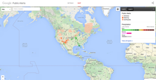
Google Public Alerts Site was an online notification service owned by Google.org that sends safety alerts and launched to the United States, Australia, Canada, Colombia, Japan, Taiwan, Indonesia, Mexico, and Brazil on October 30, 2012, and to the Philippines on November 12, 2014. It is part of the Google Crisis Response team and publishes content from its partners of each country. If you activate Google Now, you can see suitable weather and public safety on Google Search and Google Maps.
References
- ↑ "Brazil | World Meteorological Organization". community.wmo.int. Retrieved 2021-04-28.
- ↑ "Instituto Nacional de Meteorologia - INMET". portal.inmet.gov.br. Retrieved 2021-04-28.
- ↑ "Portal da Câmara dos Deputados". www2.camara.leg.br. Retrieved 2021-04-28.