South African Weather Service

Last updated

South African Weather Service
South African Weather Service logo.svg
National Weather Service overview
Formed2001;23 years ago (2001)
TypePublic
JurisdictionMeteorology
Headquarters Pretoria
25°53′26″S28°10′15″E / 25.890576579039017°S 28.170749985670785°E / -25.890576579039017; 28.170749985670785
Parent department Department of Environmental Affairs and Tourism
Website www.weathersa.co.za

The South African Weather Service (SAWS) is the meteorological service under the South African government's Department of Environmental Affairs and Tourism. SAWS is a member of the World Meteorological Organization.

Contents

The SAWS traces its lineage to the Cape of Good Hope Meteorological Commission, established in October 1860. The Union of South Africa's Weather Service was established in 1912 under the Department of Irrigation, with Charles M Stewart as its first Chief Meteorologist. [1] At some point between 1912 and 1940, the SAWS' name was changed to the Meteorological Service, and in 1940, during the Second World War, became the responsibility of the Department of Defence. In 1949, the Meteorological Service was transferred to the Department of Transport, and became the South African Weather Bureau. It became housed under the Department of Environmental Affairs in 1986. [2]

Under the South African Weather Service Act (No. 8 of 2001) effective 15 July 2001, the Weather Bureau became the South African Weather Service as a public entity. [3]

Data acquisition

Weather stations

South Africa operates a significant number of weather stations in South Africa as well as stations at Gough Island, Marion Island and Antarctica in cooperation with the South African National Antarctic Programme. [4]

List of South African Weather Stations [5]
Name WMO # ICAO Location
Alexander Bay 406FAAB 28°34′S16°32′E / 28.567°S 16.533°E / -28.567; 16.533 (Alexander Bay)
Aliwal North 546FAAN 30°43′S26°43′E / 30.717°S 26.717°E / -30.717; 26.717 (Aliwal North)
Babanango 488 28°23′S31°5′E / 28.383°S 31.083°E / -28.383; 31.083 (Babanango)
Beaufort West 728FABY 32°21′S22°35′E / 32.350°S 22.583°E / -32.350; 22.583 (Beaufort West)
Bethal 370 26°27′S29°29′E / 26.450°S 29.483°E / -26.450; 29.483 (Bethal)
Bethlehem Airport 461FABM 28°15′S28°20′E / 28.250°S 28.333°E / -28.250; 28.333 (Bethlehem Airport)
Bethlehem 462 28°10′S28°46′E / 28.167°S 28.767°E / -28.167; 28.767 (Bethlehem)
Bisho Airport752 32°50′S27°27′E / 32.833°S 27.450°E / -32.833; 27.450 (Bisho Airport)
Bloemfontein Airport 442FABL 29°6′S26°18′E / 29.100°S 26.300°E / -29.100; 26.300 (Bloemfontein Airport)
Calvinia 618FACV 31°28′S19°46′E / 31.467°S 19.767°E / -31.467; 19.767 (Calvinia)
Cape Agulhas 920 34°50′S20°1′E / 34.833°S 20.017°E / -34.833; 20.017 (Cape Agulhas)
Cape Columbine 712 32°50′S17°51′E / 32.833°S 17.850°E / -32.833; 17.850 (Cape Columbine)
Cape Point 916 34°21′S18°30′E / 34.350°S 18.500°E / -34.350; 18.500 (Cape Point)
Cape Saint Francis 938 34°12′S24°50′E / 34.200°S 24.833°E / -34.200; 24.833 (Cape Saint Francis)
Cape Saint Lucia 496 28°30′S32°24′E / 28.500°S 32.400°E / -28.500; 32.400 (Cape Saint Lucia)
Cape Town International Airport 816FACT 33°59′S18°36′E / 33.983°S 18.600°E / -33.983; 18.600 (Cape Town International Airport)
Carolina 380FACL 26°4′S30°7′E / 26.067°S 30.117°E / -26.067; 30.117 (Carolina)
Cedara 580 29°32′S30°17′E / 29.533°S 30.283°E / -29.533; 30.283 (Cedara)
Cradock 744 32°10′S25°37′E / 32.167°S 25.617°E / -32.167; 25.617 (Cradock)
De Aar 536FADA 30°39′S24°1′E / 30.650°S 24.017°E / -30.650; 24.017 (De Aar)
De Aar 538FADY 30°38′S23°55′E / 30.633°S 23.917°E / -30.633; 23.917 (De Aar)
Döhne 754 32°31′S27°28′E / 32.517°S 27.467°E / -32.517; 27.467 (Döhne)
Douglas 530 29°4′S23°45′E / 29.067°S 23.750°E / -29.067; 23.750 (Douglas)
Durban International Airport 588FADN 29°58′S30°57′E / 29.967°S 30.950°E / -29.967; 30.950 (Durban International Airport)
East London Airport 858FAEL 33°2′S27°50′E / 33.033°S 27.833°E / -33.033; 27.833 (East London Airport)
Ellisras 156FAER 23°43′35″S27°41′18″E / 23.72639°S 27.68833°E / -23.72639; 27.68833 (Ellisras)
Estcourt 478 29°00′S29°53′E / 29.000°S 29.883°E / -29.000; 29.883 (Estcourt)
Fauresmith 542 29°46′S25°19′E / 29.767°S 25.317°E / -29.767; 25.317 (Fauresmith)
Fleur De Lys 292 24°32′S31°2′E / 24.533°S 31.033°E / -24.533; 31.033 (Fleur De Lys)
Frankfort 362FAFF 27°16′S28°30′E / 27.267°S 28.500°E / -27.267; 28.500 (Frankfort)
Fraserburg 624FAFR 31°55′S21°31′E / 31.917°S 21.517°E / -31.917; 21.517 (Fraserburg)
George Airport 828FAGG 34°00′S22°23′E / 34.000°S 22.383°E / -34.000; 22.383 (George Airport)
Germiston 369 26°15′S28°9′E / 26.250°S 28.150°E / -26.250; 28.150 (Germiston)
Gough Island 906FAGE 40°21′S9°53′W / 40.350°S 9.883°W / -40.350; -9.883 (Gough Island)
Graaff Reinet 736FAGR 32°15′S24°32′E / 32.250°S 24.533°E / -32.250; 24.533 (Graaff Reinet)
Graskop 286 24°56′S30°50′E / 24.933°S 30.833°E / -24.933; 30.833 (Graskop)
Hoedspruit 290FAHS 24°22′S31°2′E / 24.367°S 31.033°E / -24.367; 31.033 (Hoedspruit)
Jansenville 738 32°56′S24°40′E / 32.933°S 24.667°E / -32.933; 24.667 (Jansenville)
Kimberley Airport 438FAKM 28°48′S24°46′E / 28.800°S 24.767°E / -28.800; 24.767 (Kimberley Airport)
Klerksdorp 347FAKD 26°52′S26°43′E / 26.867°S 26.717°E / -26.867; 26.717 (Klerksdorp)
Kroonstad 352 27°40′S27°15′E / 27.667°S 27.250°E / -27.667; 27.250 (Kroonstad)
Kuruman 332 27°28′S23°26′E / 27.467°S 23.433°E / -27.467; 23.433 (Kuruman)
Ladysmith 476FALY 28°34′S29°46′E / 28.567°S 29.767°E / -28.567; 29.767 (Ladysmith)
AFB Langebaanweg 714FALW 32°58′S18°10′E / 32.967°S 18.167°E / -32.967; 18.167 (Langebaanweg)
Levubu 182 23°5′S30°17′E / 23.083°S 30.283°E / -23.083; 30.283 (Levubu)
Lydenburg 184 25°6′S30°28′E / 25.100°S 30.467°E / -25.100; 30.467 (Lydenburg)
Macuville 180 22°16′S29°54′E / 22.267°S 29.900°E / -22.267; 29.900 (Macuville)
Mafikeng 242FAMM 25°47′S25°32′E / 25.783°S 25.533°E / -25.783; 25.533 (Mafikeng)
Makatini 400 27°24′S32°11′E / 27.400°S 32.183°E / -27.400; 32.183 (Makatini)
Mara 176 23°9′S29°34′E / 23.150°S 29.567°E / -23.150; 29.567 (Mara)
Marion Island 994FAME 46°53′S37°52′E / 46.883°S 37.867°E / -46.883; 37.867 (Marion Island)
Marnitz 162 23°9′S28°13′E / 23.150°S 28.217°E / -23.150; 28.217 (Marnitz)
Matatiele 570 30°21′S28°48′E / 30.350°S 28.800°E / -30.350; 28.800 (Matatiele)
Middelburg 638FAMB 31°29′S25°2′E / 31.483°S 25.033°E / -31.483; 25.033 (Middelburg)
Mossel Bay 928FAMO 34°11′S22°9′E / 34.183°S 22.150°E / -34.183; 22.150 (Mossel Bay)
Nelspruit 288FANS 25°26′S30°59′E / 25.433°S 30.983°E / -25.433; 30.983 (Nelspruit)
Newcastle 378 27°44′S29°55′E / 27.733°S 29.917°E / -27.733; 29.917 (Newcastle)
O. R. Tambo International Airport 368FAOR 26°8′S28°14′E / 26.133°S 28.233°E / -26.133; 28.233 (OR Tambo International Airport)
Ottosdal 342 26°49′S26°1′E / 26.817°S 26.017°E / -26.817; 26.017 (Ottosdal)
Oudestad 272 25°11′S29°20′E / 25.183°S 29.333°E / -25.183; 29.333 (Oudestad)
Oudtshoorn 826FAOH 33°34′S22°13′E / 33.567°S 22.217°E / -33.567; 22.217 (Oudtshoorn)
Phalaborwa 190FAPH 23°56′S31°9′E / 23.933°S 31.150°E / -23.933; 31.150 (Phalaborwa)
Pietersburg 174FAPB 23°52′S29°27′E / 23.867°S 29.450°E / -23.867; 29.450 (Pietersburg)
Piet Retief 388 27°2′S30°48′E / 27.033°S 30.800°E / -27.033; 30.800 (Piet Retief)
Pilansberg 250 25°20′S27°10′E / 25.333°S 27.167°E / -25.333; 27.167 (Pilansberg)
Plessisdraai 344 27°59′S26°8′E / 27.983°S 26.133°E / -27.983; 26.133 (Plessisdraai)
Pofadder 416 29°8′S19°23′E / 29.133°S 19.383°E / -29.133; 19.383 (Pofadder)
Port Elizabeth Airport 842FAPE 33°59′S25°36′E / 33.983°S 25.600°E / -33.983; 25.600 (Port Elizabeth Airport)
Port Nolloth 408 29°14′S16°52′E / 29.233°S 16.867°E / -29.233; 16.867 (Port Nolloth)
Port Shepstone 584 30°44′S30°27′E / 30.733°S 30.450°E / -30.733; 30.450 (Port Shepstone)
Port St Johns 674FAPJ 31°38′S29°33′E / 31.633°S 29.550°E / -31.633; 29.550 (Port St Johns)
Postmasburg 430 28°19′S23°4′E / 28.317°S 23.067°E / -28.317; 23.067 (Postmasburg)
Potchefstroom Agric.350 26°44′S27°4′E / 26.733°S 27.067°E / -26.733; 27.067 (Potchefstroom Agric.)
Potchefstroom Upper-Air351 26°40′S27°6′E / 26.667°S 27.100°E / -26.667; 27.100 (Potchefstroom Upper-Air)
Potgietersrus 276 24°11′S29°1′E / 24.183°S 29.017°E / -24.183; 29.017 (Potgietersrus)
Pretoria (Irene)263FAIR 25°55′S28°13′E / 25.917°S 28.217°E / -25.917; 28.217 (Pretoria (Irene))
Pretoria 262FAPR 25°44′S28°11′E / 25.733°S 28.183°E / -25.733; 28.183 (Pretoria)
Prieska 528 29°40′S22°45′E / 29.667°S 22.750°E / -29.667; 22.750 (Prieska)
Queenstown 648FAQT 31°54′S26°52′E / 31.900°S 26.867°E / -31.900; 26.867 (Queenstown)
Richard Bay 498FARB 28°48′S32°6′E / 28.800°S 32.100°E / -28.800; 32.100 (Richard Bay)
Riversdale 926 34°5′S21°15′E / 34.083°S 21.250°E / -34.083; 21.250 (Riversdale)
Robertson 718 33°50′S19°54′E / 33.833°S 19.900°E / -33.833; 19.900 (Robertson)
Rustenburg 252 25°43′S27°18′E / 25.717°S 27.300°E / -25.717; 27.300 (Rustenburg)
Shaleburn 572 29°48′S29°21′E / 29.800°S 29.350°E / -29.800; 29.350 (Shaleburn)
Sheeprun 564 30°59′S28°23′E / 30.983°S 28.383°E / -30.983; 28.383 (Sheeprun)
Skukuza 296 24°59′S31°36′E / 24.983°S 31.600°E / -24.983; 31.600 (Skukuza)
Somerset East 742 32°44′S25°35′E / 32.733°S 25.583°E / -32.733; 25.583 (Somerset East)
Springbok 512FASB 29°40′S17°52′E / 29.667°S 17.867°E / -29.667; 17.867 (Springbok)
Standerton 372 26°56′S29°14′E / 26.933°S 29.233°E / -26.933; 29.233 (Standerton)
Sutherland 722 32°23′S20°40′E / 32.383°S 20.667°E / -32.383; 20.667 (Sutherland)
Taung 336 27°33′S24°46′E / 27.550°S 24.767°E / -27.550; 24.767 (Taung)
Thabazimbi 254 24°35′S27°25′E / 24.583°S 27.417°E / -24.583; 27.417 (Thabazimbi)
Thohoyandou 192 22°58′S30°30′E / 22.967°S 30.500°E / -22.967; 30.500 (Thohoyandou)
Touws River 818 33°21′S20°3′E / 33.350°S 20.050°E / -33.350; 20.050 (Touws River)
Tristan Da Cunha 902FATC 37°3′S12°19′W / 37.050°S 12.317°W / -37.050; -12.317 (Tristan Da Cunha)
Tswelopele 284 24°39′S30°17′E / 24.650°S 30.283°E / -24.650; 30.283 (Tswelopele)
Twee Riviere 322 26°28′S20°37′E / 26.467°S 20.617°E / -26.467; 20.617 (Twee Riviere)
Tzaneen 186 23°50′S30°9′E / 23.833°S 30.150°E / -23.833; 30.150 (Tzaneen)
Umtata 668FAUT 31°32′S28°40′E / 31.533°S 28.667°E / -31.533; 28.667 (Umtata)
Upington Airport 424FAUP 28°24′S21°16′E / 28.400°S 21.267°E / -28.400; 21.267 (Upington Airport)
Vanwyksvlei 524 30°21′S21°49′E / 30.350°S 21.817°E / -30.350; 21.817 (Vanwyksvlei)
Vanzylsrus 330 26°53′S22°3′E / 26.883°S 22.050°E / -26.883; 22.050 (Vanzylsrus)
Vredendal 614FAVR 31°40′S18°30′E / 31.667°S 18.500°E / -31.667; 18.500 (Vredendal)
Vryburg 338FAVB 26°57′S24°38′E / 26.950°S 24.633°E / -26.950; 24.633 (Vryburg)
Warmbaths 268 24°54′S28°20′E / 24.900°S 28.333°E / -24.900; 28.333 (Warmbaths)
AFB Waterkloof 264FAWK 25°50′S28°13′E / 25.833°S 28.217°E / -25.833; 28.217
Welkom 346FAWM 28°00′S26°40′E / 28.000°S 26.667°E / -28.000; 26.667 (Welkom)
Wepener 550 29°44′S27°2′E / 29.733°S 27.033°E / -29.733; 27.033 (Wepener)
Willowmore 832 33°17′S23°30′E / 33.283°S 23.500°E / -33.283; 23.500 (Willowmore)

Weather radar

Near real-time (~5 minutes delay) weather radar is available for most of the country, [6] even within the Kruger National Park. [7]

Marine weather buoys

Between 30 and 40 drifting weather buoys are deployed annually. [4]

Weather modification

The SAWS, in cooperation with a number of other entities, is actively involved in weather control research under the South African National Precipitation Research and Rainfall Enhancement Programme, specifically with the Bethlehem Precipitation Research Project. [8] [9]

See also

Related Research Articles

<span class="mw-page-title-main">Weather forecasting</span> Science and technology application

Weather forecasting is the application of science and technology to predict the conditions of the atmosphere for a given location and time. People have attempted to predict the weather informally for millennia and formally since the 19th century.

<span class="mw-page-title-main">Climate of Antarctica</span> Overview of climactic conditions in Antarctica

The climate of Antarctica is the coldest on Earth. The continent is also extremely dry, averaging 166 mm (6.5 in) of precipitation per year. Snow rarely melts on most parts of the continent, and, after being compressed, becomes the glacier ice that makes up the ice sheet. Weather fronts rarely penetrate far into the continent, because of the katabatic winds. Most of Antarctica has an ice-cap climate with extremely cold and dry weather.

<span class="mw-page-title-main">Casey Station</span> Antarctic base in Australian Antarctic Territory

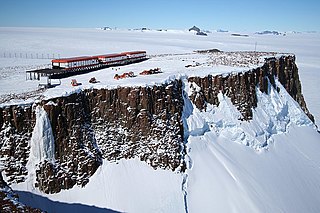
Casey Station, commonly called Casey, is one of three permanent stations and research outposts in Antarctica managed by the Australian Antarctic Division (AAD). Casey lies on the northern side of the Bailey Peninsula overlooking Vincennes Bay on the Budd Coast of Wilkes Land in the Australian Antarctic Territory, a territory claimed by Australia. Casey is 3,880 kilometres (2,410 mi) due south of Perth, Western Australia.

<span class="mw-page-title-main">Weather station</span> Facility for atmospheric research and prediction

A weather station is a facility, either on land or sea, with instruments and equipment for measuring atmospheric conditions to provide information for weather forecasts and to study the weather and climate. The measurements taken include temperature, atmospheric pressure, humidity, wind speed, wind direction, and precipitation amounts. Wind measurements are taken with as few other obstructions as possible, while temperature and humidity measurements are kept free from direct solar radiation, or insolation. Manual observations are taken at least once daily, while automated measurements are taken at least once an hour. Weather conditions out at sea are taken by ships and buoys, which measure slightly different meteorological quantities such as sea surface temperature (SST), wave height, and wave period. Drifting weather buoys outnumber their moored versions by a significant amount.

<span class="mw-page-title-main">Precipitation</span> Product of the condensation of atmospheric water vapor that falls under gravity

In meteorology, precipitation is any product of the condensation of atmospheric water vapor that falls from clouds due to gravitational pull. The main forms of precipitation include drizzle, rain, sleet, snow, ice pellets, graupel and hail. Precipitation occurs when a portion of the atmosphere becomes saturated with water vapor, so that the water condenses and "precipitates" or falls. Thus, fog and mist are not precipitation but colloids, because the water vapor does not condense sufficiently to precipitate. Two processes, possibly acting together, can lead to air becoming saturated: cooling the air or adding water vapor to the air. Precipitation forms as smaller droplets coalesce via collision with other rain drops or ice crystals within a cloud. Short, intense periods of rain in scattered locations are called showers.

<span class="mw-page-title-main">National Weather Service</span> U.S. forecasting agency of the National Oceanic and Atmospheric Administration

The National Weather Service (NWS) is an agency of the United States federal government that is tasked with providing weather forecasts, warnings of hazardous weather, and other weather-related products to organizations and the public for the purposes of protection, safety, and general information. It is a part of the National Oceanic and Atmospheric Administration (NOAA) branch of the Department of Commerce, and is headquartered in Silver Spring, Maryland, within the Washington metropolitan area. The agency was known as the United States Weather Bureau from 1890 until it adopted its current name in 1970.

<span class="mw-page-title-main">Prince Edward Islands</span> Two small sub-Antarctic islands belonging to South Africa

The Prince Edward Islands are two small uninhabited islands in the sub-Antarctic Indian Ocean that are part of South Africa which are named Marion Island and Prince Edward Island.

<span class="mw-page-title-main">Weather radar</span> Radar used to locate and monitor meteorological conditions

Weather radar, also called weather surveillance radar (WSR) and Doppler weather radar, is a type of radar used to locate precipitation, calculate its motion, and estimate its type. Modern weather radars are mostly pulse-Doppler radars, capable of detecting the motion of rain droplets in addition to the intensity of the precipitation. Both types of data can be analyzed to determine the structure of storms and their potential to cause severe weather.

<span class="mw-page-title-main">PAGASA</span> National weather, climate, and astronomy bureau of the Philippines

The Philippine Atmospheric, Geophysical and Astronomical Services Administration is the National Meteorological and Hydrological Services (NMHS) agency of the Philippines mandated to provide protection against natural calamities and to ensure the safety, well-being and economic security of all the people, and for the promotion of national progress by undertaking scientific and technological services in meteorology, hydrology, climatology, astronomy and other geophysical sciences. Created on December 8, 1972, by reorganizing the Weather Bureau, PAGASA now serves as one of the Scientific and Technological Services Institutes of the Department of Science and Technology.

<span class="mw-page-title-main">South African National Antarctic Programme</span> Government research programme

The South African National Antarctic Programme is the South African government's programme for research in the Antarctic and Subantarctic. Three research stations fall under this programme: the Antarctica research station SANAE IV, and one station each on the subantarctic islands Gough Island and Marion Island. These stations are managed and administered by the Directorate: Antarctic and Islands of the Department of Environmental Affairs. Borga Base was also operated by SANAP from 1969 to 1976.

<span class="mw-page-title-main">SANAE IV</span> Antarctic base

SANAE IV is a current South African Antarctic research base located in Vesleskarvet, Queen Maud Land. The base is part of the South African National Antarctic Program (SANAP) and is operated by the South African National Antarctic Expedition.

<span class="mw-page-title-main">Rain</span> Precipitation in the form of water droplets

Rain is water droplets that have condensed from atmospheric water vapor and then fall under gravity. Rain is a major component of the water cycle and is responsible for depositing most of the fresh water on the Earth. It provides water for hydroelectric power plants, crop irrigation, and suitable conditions for many types of ecosystems.

<span class="mw-page-title-main">Nowcasting (meteorology)</span>

Nowcasting is weather forecasting on a very short term mesoscale period of up to 2 hours, according to the World Meteorological Organization, and up to six hours, according to other authors in the field. This forecast is an extrapolation in time of known weather parameters, including those obtained by means of remote sensing, using techniques that take into account a possible evolution of the air mass. This type of forecast therefore includes details that cannot be solved by numerical weather prediction (NWP) models running over longer forecast periods.

The flash flood guidance system (FFGS) was designed and developed by the Hydrologic Research Center, a non-profit public-benefit corporation located in San Diego, CA, US, for use by meteorological and hydrologic forecasters throughout the world. The primary purpose of the FFGS is to provide operational forecasters and disaster management agencies with real-time information pertaining to the threat of small-scale flash flooding throughout a specified region.

Meteorological Service Singapore (MSS) is the national meteorological service of Singapore. It is responsible for gathering and recording weather data across the country, issuing weather forecasts, and performing research into Singapore's weather and climate. It is a division of the National Environment Agency, a statutory board under the Ministry of Sustainability and the Environment.

<span class="mw-page-title-main">Observer (meteorological)</span>

A meteorological observer, or weather observer, is a person authorized by a weather authority to make or record meteorological observations. They are technicians who are responsible for the accurate observation, rapid measurement, timely collection, recording, and timely submission of meteorological parameters and information and various atmospheric phenomena to the Meteorological Center. Surface, upper air, radar, and satellite are all forms of weather observations.

<span class="mw-page-title-main">Palestinian Meteorological Department</span>

The Palestinian Meteorological Department (PMD), known as الأرصاد الجوية الفلسطينية in Arabic, is an organization that operates under the Ministry of Transportation. Its mission is to effectively utilize weather conditions to directly or indirectly serve various sectors of life and contribute to the development of the national economy in fields such as agriculture, water, energy, aviation, maritime navigation, scientific research, and public health. The first observations in Mandatory Palestine date from 1923, but the department was created in 1994 by the Palestinian National Authority after the Oslo Accords.

References

  1. "Stewart, Mr Charles M (meteorology)". Biographical Database of Southern African Science. 26 November 2023. Archived from the original on 26 November 2023. Retrieved 26 November 2023.
  2. "Library". Regional Training Centre, South African Weather Service. 26 November 2023. Archived from the original on 26 November 2023. Retrieved 26 November 2023.
  3. "S A Weather Service Act (8 of 2001)". The Presidency of South Africa. 29 June 2001. Archived from the original on 3 December 2008. Retrieved 4 December 2008.
  4. 1 2 "Weather Program". South African National Antarctic Program. Archived from the original on 28 August 2008. Retrieved 4 December 2008.
  5. "Meteorological Station Location Information". National Oceanic and Atmospheric Administration . Retrieved 4 December 2008.
  6. "Radar Home". South African Weather Service. Archived from the original on 18 December 2008. Retrieved 4 December 2008.
  7. Nick Zambatis and Lynette Strauss. "Radar Station Completed". Siyabona Africa Travel. Retrieved 4 December 2008.
  8. "The Bethlehem Precipitation Research Project". South African Weather Service. Archived from the original on 14 January 2009. Retrieved 4 December 2008.
  9. "South African National Precipitation Research and Rainfall Enhancement Programme (NPRP-SAREP) 1990 – 2000". South African Water Research Commission. Retrieved 4 December 2008.[ dead link ]