Alabaster is a mineral or rock that is soft, often used for carving, and is processed for plaster powder. Archaeologists and the stone processing industry use the word differently from geologists. The former use it in a wider sense that includes varieties of two different minerals: the fine-grained massive type of gypsum and the fine-grained banded type of calcite. Geologists define alabaster only as the gypsum type. Chemically, gypsum is a hydrous sulfate of calcium, while calcite is a carbonate of calcium.

Clay is a type of fine-grained natural soil material containing clay minerals (hydrous aluminium phyllosilicates, e.g. kaolinite, Al2Si2O5(OH)4).

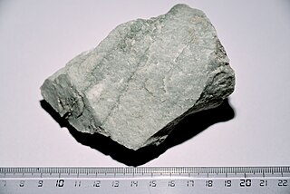
Soapstone is a talc-schist, which is a type of metamorphic rock. It is composed largely of the magnesium rich mineral talc. It is produced by dynamothermal metamorphism and metasomatism, which occur in the zones where tectonic plates are subducted, changing rocks by heat and pressure, with influx of fluids, but without melting. It has been a medium for carving for thousands of years.
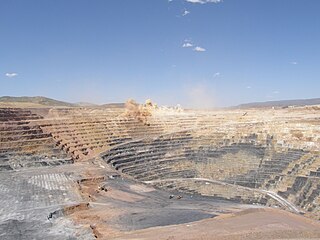
Open-pit mining, also known as open-cast or open-cut mining and in larger contexts mega-mining, is a surface mining technique of extracting rock or minerals from the earth from an open-air pit, sometimes known as a borrow.

Porphyry is any of various decorative granites or igneous rocks with coarse-grained crystals such as feldspar or quartz dispersed in a fine-grained silicate-rich, generally aphanitic matrix or groundmass. The larger crystals are called phenocrysts. In its non-geologic, traditional use, the term porphyry usually refers to the purple-red form of this stone, valued for its appearance, but other colours of decorative porphyry are also used such as "green", "black" and "grey".
Quartzite is a hard, non-foliated metamorphic rock which was originally pure quartz sandstone. Sandstone is converted into quartzite through heating and pressure usually related to tectonic compression within orogenic belts. Pure quartzite is usually white to grey, though quartzites often occur in various shades of pink and red due to varying amounts of hematite. Other colors, such as yellow, green, blue and orange, are due to other minerals.

Pyrophyllite is a phyllosilicate mineral composed of aluminium silicate hydroxide: Al2Si4O10(OH)2. It occurs in two forms (habits): crystalline folia and compact masses; distinct crystals are not known.

Diabase, also called dolerite or microgabbro, is a mafic, holocrystalline, subvolcanic rock equivalent to volcanic basalt or plutonic gabbro. Diabase dikes and sills are typically shallow intrusive bodies and often exhibit fine-grained to aphanitic chilled margins which may contain tachylite.

Trap rock, also known as either trapp or trap, is any dark-colored, fine-grained, non-granitic intrusive or extrusive igneous rock. Types of trap rock include basalt, peridotite, diabase, and gabbro. Trapp (trap) is also used to refer to flood (plateau) basalts, e.g. the Deccan Traps and Siberian Traps. The erosion of trap rock created by the stacking of successive lava flows often created a distinct stairstep landscape from which the term trap was derived from the Swedish word trappa, which means "stairway".
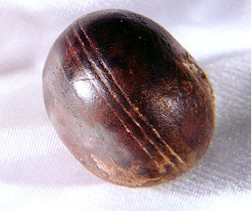
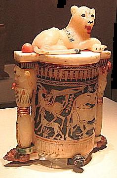
Klerksdorp spheres are small objects, often spherical to disc-shaped, that have been collected by miners and rockhounds from 3-billion-year-old pyrophyllite deposits mined by Wonderstone Ltd., near Ottosdal, South Africa. They have been cited by pseudoscientists and reporters in books, popular articles, and many web pages as inexplicable out-of-place artifacts that could only have been manufactured by intelligent beings. Geologists who have studied these objects have concluded that the objects are not manufactured, but are rather the result of natural processes.
Heavitree stone is a type of breccia stone, red in colour, of very coarse texture and prone to weathering, which occurs naturally in the parish of Heavitree near the City of Exeter in Devon, England. It was quarried in the area from about 1350 to the 19th century, and was used to construct many of Exeter's older buildings, including Exeter Castle, the old city walls, and many of the almshouses and parish churches. Many ancient buildings in Exeter made of Heavitree stone were destroyed by enemy bombing during World War II. It was first referred to by Sir Henry De La Beche in 1839, as the "Conglomerates of Heavitree".

Crushed stone or angular rock is a form of construction aggregate, typically produced by mining a suitable rock deposit and breaking the removed rock down to the desired size using crushers. It is distinct from naturally occurring gravel, which is produced by natural processes of weathering and erosion and typically has a more rounded shape.
This glossary of geology is a list of definitions of terms and concepts relevant to geology, its sub-disciplines, and related fields. For other terms related to the Earth sciences, see Glossary of geography terms.
Tonstein is a hard, compact sedimentary rock that is composed mainly of kaolinite or, less commonly, other clay minerals such as montmorillonite and illite. The clays often are cemented by iron oxide minerals, carbonaceous matter, or chlorite. Tonsteins form from volcanic ash deposited in swamps. Tonsteins occur as distinctive, thin, and laterally extensive layers in coal seams throughout the world. They are often used as key beds to correlate the strata in which they are found. The regional persistence of tonsteins and relict phenocrysts indicate that they formed as the result of the diagenetic alteration of volcanic ash falls in an acidic and low-salinity environment, consistent with a freshwater swamp. In contrast, the alteration of a volcanic ashfall deposit in a marine environment typically produces a bentonite layer.
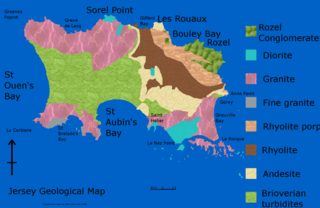
The geology of Jersey is characterised by the Late Proterozoic Brioverian volcanics, the Cadomian Orogeny, and only small signs of later deposits from the Cambrian and Quaternary periods. The kind of rocks go from conglomerate to shale, volcanic, intrusive and plutonic igneous rocks of many compositions, and metamorphic rocks as well, thus including most major types.
The Piégut-Pluviers Granodiorite is situated at the northwestern edge of the Variscan Massif Central in France. Its cooling age has been determined as 325 ± 14 million years BP.

The geology of England's Lake District is dominated by sedimentary and volcanic rocks of mainly Ordovician age underpinned by large granitic intrusions. Younger sedimentary sequences outcrop on the edges of the Lake District area, with Silurian to the south, Carboniferous to the north, east and west and Permo-Triassic to the west and east. The entire area was covered by a Mesozoic sequence that was eroded off during Paleogene uplift related to the opening of the North Atlantic. During the Quaternary the area was affected by repeated glaciations, which sculpted the current mountainous landscape.

The geology of Ghana is primarily very ancient crystalline basement rock, volcanic belts and sedimentary basins, affected by periods of igneous activity and two major orogeny mountain building events. Aside from modern sediments and some rocks formed within the past 541 million years of the Phanerozoic Eon, along the coast, many of the rocks in Ghana formed close to one billion years ago or older leading to five different types of gold deposit formation, which gave the region its former name Gold Coast.

The geology of Sierra Leone is primarily very ancient Precambrian Archean and Proterozoic crystalline igneous and metamorphic basement rock, in many cases more than 2.5 billion years old. Throughout Earth history, Sierra Leone was impacted by major tectonic and climatic events, such as the Leonean, Liberian and Pan-African orogeny mountain building events, the Neoproterozoic Snowball Earth and millions of years of weathering, which has produced thick layers of regolith across much of the country's surface.

The geology of North Macedonia includes the study of rocks dating to the Precambrian and a wide array of volcanic, sedimentary and metamorphic rocks formed in the last 539 million years.


