The Atlantic Ocean is the second largest of the world's oceans, with an area of about 106,460,000 square kilometers. It covers approximately 20 percent of the Earth's surface and about 29 percent of its water surface area. It separates the "Old World" from the "New World".
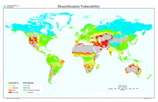
Desertification is a type of land degradation in which a relatively dry area of land becomes a desert, typically losing its bodies of water as well as vegetation and wildlife. It is caused by a variety of factors, such as through climate change and through the overexploitation of soil through human activity. When deserts appear automatically over the natural course of a planet's life cycle, then it can be called a natural phenomenon; however, when deserts emerge due to the rampant and unchecked depletion of nutrients in soil that are essential for it to remain arable, then a virtual "soil death" can be spoken of, which traces its cause back to human overexploitation. Desertification is a significant global ecological and environmental problem with far reaching consequences on socio-economic and political conditions.

Namibia, officially the Republic of Namibia, is a country in southern Africa. Its western border is the Atlantic Ocean; it shares land borders with Zambia and Angola to the north, Botswana to the east and South Africa to the south and east. Although it does not border Zimbabwe, less than 200 metres of the Zambezi River separates the two countries. Namibia gained independence from South Africa on 21 March 1990, following the Namibian War of Independence. Its capital and largest city is Windhoek, and it is a member state of the United Nations (UN), the Southern African Development Community (SADC), the African Union (AU), and the Commonwealth of Nations.
The Niger River is the principal river of West Africa, extending about 4,180 km (2,600 mi). Its drainage basin is 2,117,700 km2 (817,600 sq mi) in area. Its source is in the Guinea Highlands in southeastern Guinea. It runs in a crescent through Mali, Niger, on the border with Benin and then through Nigeria, discharging through a massive delta, known as the Niger Delta or the Oil Rivers, into the Gulf of Guinea in the Atlantic Ocean. The Niger is the third-longest river in Africa, exceeded only by the Nile and the Congo River. Its main tributary is the Benue River.

A developing country is a country with a less developed industrial base and a low Human Development Index (HDI) relative to other countries. However, this definition is not universally agreed upon. There is also no clear agreement on which countries fit this category. A nation's GDP per capita compared with other nations can also be a reference point.

The Caspian tern is a species of tern, with a subcosmopolitan but scattered distribution. Despite its extensive range, it is monotypic of its genus, and has no accepted subspecies. The genus name is from Ancient Greek hudros, "water", and Latin progne, "swallow". The specific caspia is from Latin and, like the English name, refers to the Caspian Sea.

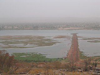
Djenné is a town and an urban commune in the Inland Niger Delta region of central Mali. The town is the administrative centre of the Djenné Cercle, one of the eight subdivisions of the Mopti Region. The commune includes ten of the surrounding villages and in 2009 had a population of 32,944.

Jonglei is a state of South Sudan. On 2 October 2015 the President Salva Kiir Mayardit decreed the creation of the new Jonglei State along with 27 other states replacing 10 previous states. The earlier Jonglei state comprised three counties of Bor, Twic East and Duk and was the largest state by area before reorganisation, with approximately 122,581 km2, as well as the most populous according to the controversial 2008 census conducted during present-day South Sudan's second period of autonomy. Bor is the capital of the state.

The Allagash River is a tributary of the Saint John River, approximately 65 miles (105 km) long, in northern Maine in the United States. It drains in a remote and scenic area of wilderness in the Maine North Woods north of Mount Katahdin. The name "Allagash" comes from the Abenaki language, a dialect of the Algonquin languages, spoken by the Penobscot Tribe The word, /walakéskʸihtəkʸ/, means "bark stream".

The Ferlo Desert, also known as the Ferio Desert, is a desert in northern-central Senegal. It is inhabited by the Serer and the Fulani.

Mohale Dam is a concrete faced rock-fill dam in Lesotho. It is the second dam, under Phase 1B of the series of dams of the proposed Lesotho Highlands Water Project (LHWP), which will eventually include five large dams in remote rural areas of Lesotho and South Africa. The project has been built at a cost of US$1.5 billion.

South Africa, officially the Republic of South Africa (RSA), is the southernmost country in Africa. It is bounded to the south by 2,798 kilometres (1,739 mi) of coastline of Southern Africa stretching along the South Atlantic and Indian Oceans; to the north by the neighbouring countries of Namibia, Botswana, and Zimbabwe; and to the east and northeast by Mozambique and Eswatini (Swaziland); and it surrounds the enclaved country of Lesotho. South Africa is the largest country in Southern Africa and the 25th-largest country in the world by land area and, with over 57 million people, is the world's 24th-most populous nation. It is the southernmost country on the mainland of the Old World or the Eastern Hemisphere. About 80 percent of South Africans are of Sub-Saharan African ancestry, divided among a variety of ethnic groups speaking different African languages, nine of which have official status. The remaining population consists of Africa's largest communities of European (White), Asian (Indian), and multiracial (Coloured) ancestry.
South African National Parks (SANParks) is the body responsible for managing South Africa's national parks. SANParks was formed in 1926, and currently manages 21 parks consisting of over 4,000,000 hectares (40,000 km2), over 3% of the total area of South Africa.

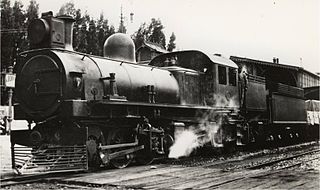
The South African Railways Class 4 4-8-2 of 1911 was a steam locomotive from the pre-Union era in the Cape of Good Hope.
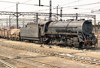
The South African Railways Class S1 0-8-0 of 1947 was a steam locomotive.
The South African Railways Class KM 0-6-0+0-6-0 of 1904 was an articulated steam locomotive from the pre-Union era in Transvaal Colony.
The South African Railways Class FD 2-6-2+2-6-2 of 1926 was an articulated steam locomotive.
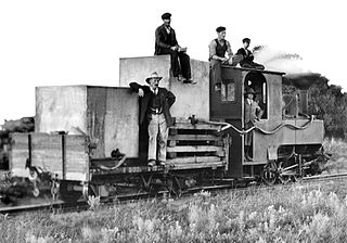
The Cape Government Railways NG 0-6-0T of 1903 was a South African steam locomotive from the pre-Union era in the Cape of Good Hope.

South African steam locomotive tenders were classified by means of type letters and sometimes numbers, while locomotive specifications included a list of permissible tenders which could be used with each engine class.
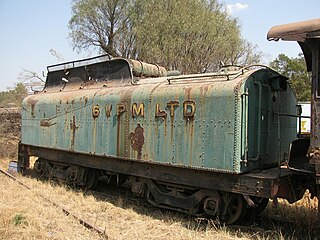
The South African type GT tender was a steam locomotive tender.