
Ratchaburi province or Rat Buri is one of Thailand's seventy-six provinces (changwat) lies in Western Thailand. Neighbouring provinces are Kanchanaburi, Nakhon Pathom, Samut Sakhon, Samut Songkhram and Phetchaburi. In the west it borders the Tanintharyi Region of Myanmar.

Roi Et is one of Thailand's seventy-six provinces (changwat) lies in central northeastern Thailand also called Isan. Neighboring provinces are Kalasin, Mukdahan, Yasothon, Sisaket, Surin, and Maha Sarakham.

The Eastern Cape is one of the nine provinces of South Africa. Its capital is Bhisho, and its largest city is Gqeberha. Due to its climate and nineteenth-century towns, it is a common location for tourists. It is also known for having been home to many anti-apartheid activists, including Nelson Mandela.

North West is a province of South Africa. Its capital is Mahikeng. The province is located to the west of the major population centre and province of Gauteng and south of Botswana.

Kandahār is one of the thirty four provinces of Afghanistan, located in the southern part of the country, sharing a border with Pakistan, to the south. It is surrounded by Helmand in the west, Uruzgan in the north and Zabul Province in the east. Its capital is the city of Kandahar, Afghanistan's second largest city, located on the Arghandab River. The greater region surrounding the province is called Loy Kandahar. The Emir of Afghanistan sends orders to Kabul from Kandahar making it the de facto capital of Afghanistan, although the main government body operates in Kabul. All meetings with the Emir take place in Kandahar, meetings excluding the Emir are in Kabul.

Huancavelica is a department and region in Peru with an area of 22,131.47 km2 (8,545.01 sq mi) and a population of 347,639. The capital is the city Huancavelica. The region is bordered by the departments of Lima and Ica in the west, Junín in the north, and Ayacucho in the east.

Klerksdorp is located in the North West Province, South Africa. Klerksdorp is located 165 km (103 mi) southeast of Mahikeng, the provincial capital. Klerksdorp was also the first capital of the then Transvaal Republic and used to be the home of the first Stock Exchange in the region. It became an important trading town linking Kimberley to Johannesburg. It became home to a mix of farmers, miners and immigrants servicing the two industries.It was then located there because of availability of water and climate change.

Wewak is the capital of the East Sepik province of Papua New Guinea. It is on the northern coast of the island of New Guinea. It is the largest town between Madang and Jayapura. It is the see city (seat) of the Roman Catholic Diocese of Wewak.

The Northern Region is one of the sixteen regions of Ghana. It is situated in the northern part of the country and ranks as the second largest of the sixteen regions. Before its division, it covered an area of 25,000 square kilometres, representing 10 percent of Ghana's area. In December 2018, the Savannah Region and North East Region were created from it. The Northern Region is divided into 16 districts. The region's capital is Tamale, Ghana's third largest city.

North 24 Parganas (abv. 24 PGS (N)) or sometimes North Twenty Four Parganas is a district in southern West Bengal, of eastern India. North 24 Parganas extends in the tropical zone from latitude 22° 11′ 6″ north to 23° 15′ 2″ north and from longitude 88º20' east to 89º5' east. Barasat is the district headquarters of North 24 Parganas. North 24 Parganas is West Bengal's most populous district and also (since 2014) the most populated district in the whole of India. It is the tenth-largest district in the State by area.

Achham is a district located in Sudurpashchim province of Nepal. It is one of the nine districts of the province. The district, with Mangalsen as its district headquarters, covers an area of 1,692 km2 and has a population (2011) of 257,477.

Mondulkiri is a province (khaet) of Cambodia. Bordering the provinces of Kratié to the west, Stung Treng to the northwest, Ratanakiri to the north, and the country of Vietnam to the east and south. It is the most sparsely populated province in the country despite being the largest in land area. The province was established in 1961 from the eastern part of Kratié province. The capital is the town of Senmonorom.
The magistrates' courts are the lowest level of the court system in South Africa. They are the courts of first instance for most criminal cases except for the most serious crimes, and for civil cases where the value of the claim is below a fixed monetary limit.
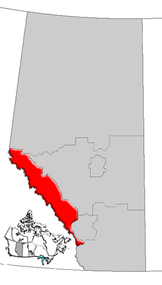
Alberta's Rockies comprise the Canadian Rocky Mountains in Alberta, Canada. On the southwestern part of the province along the British Columbia border, the region covers all but the south of Census Division 15.
Krouch Chhmar District is a district (srok) located in Tboung Khmum Province, Cambodia. The district capital is Krouch Chhmar town located around 35 kilometres north east of the provincial capital of Kampong Cham by water. The Mekong River forms western and northern borders of the districts and includes the Mekong island of Koh Pir in its area. Not surprisingly, communities in this isolated district are mostly clustered along the banks of the river and boats are an important form of transport.

Bidhannagar subdivision is an administrative subdivision of the North 24 Parganas district in the Indian state of West Bengal. After transferring Rajarhat-Gopalpur Municipality and Rajarhat to Bidhannagar subdivision, Bidhannagar subdivision's total area becomes 141.37 km2, the population becomes 808,251, and density becomes 5,700/km2.

Ramotshere Moiloa Municipality, formerly Zeerust Municipality, is a local municipality within the Ngaka Modiri Molema District Municipality, in the North West province of South Africa. The seat of the municipality is Zeerust.
Dinokana is a town on the N4 road in Ngaka Modiri Molema District Municipality in the North West province of South Africa.


