The West Bank, so called due to its location relative to the Jordan River, is the larger of the two Palestinian territories that comprise the State of Palestine. A landlocked territory near the coast of the Mediterranean Sea in the Levant region of West Asia, it is bordered by Jordan and the Dead Sea to the east and by Israel to the south, west, and north. Since 1967, the territory has been occupied by Israel and in 2024 an advisory opinion of the International Court of Justice determined that the occupation is illegal under international law.

The University of South Dakota (USD) is a public research university in Vermillion, South Dakota. Established by the Dakota Territory legislature in 1862, 27 years before the establishment of the state of South Dakota, USD is the flagship university for the state of South Dakota and the state's oldest public university. It occupies a 274 acres (1.11 km2) campus located in southeastern South Dakota, approximately 63 miles (101 km) southwest of Sioux Falls, 39 miles (63 km) northwest of Sioux City, Iowa, and north of the Missouri River.
Kgosi Lucas Manyane Mangope was the leader of the Bantustan (homeland) of Bophuthatswana. The territory he ruled over was distributed between the Orange Free State – what is now Free State – and North West Province. He was also the founder and leader of the United Christian Democratic Party, a political party based in the North West of South Africa.

Bedok is a planning area and residential town located in the geographical region of Tanah Merah along the south-eastern coast of the East Region of Singapore. Bedok is bounded by five other planning areas: Paya Lebar to the north, Hougang to the northwest, Tampines to the northeast and east, Geylang to the west and Marine Parade to the southwest. It also shares a maritime boundary with the Singapore Strait to the south and southeast.

The Hualapai is a federally recognized Native American tribe in Arizona with about 2300 enrolled members. Approximately 1353 enrolled members reside on the Hualapai Reservation, which spans over three counties in Northern Arizona.

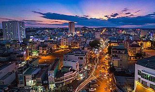
Pleiku is a city in central Vietnam, located in the Central Highlands region. It is the capital of the Gia Lai Province. Many years ago, it was inhabited primarily by the Bahnar and Jarai ethnic groups, sometimes known as the Montagnards or Degar, although now it is inhabited primarily by the Kinh ethnic group. The city is the centre of the urban district of Pleiku which covers an area of 260.77 km².

Shu, also known as Ancient Shu in historiography, was an ancient kingdom in what is now Sichuan Province. It was based on the Chengdu Plain, in the western Sichuan basin with some extension northeast to the upper Han River valley. To the east was the Ba tribal confederation. Further east down the Han and Yangtze rivers was the State of Chu. To the north over the Qinling Mountains was the State of Qin. To the west and south were tribal peoples of little military power.

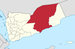
Hadhramaut Governorate is a governorate of Yemen. Lying within the large historical region of Hadhramaut, it is the country's largest governorate. The capital of Hadhramaut is the city of Mukalla. Other cities in Hadhramaut include the historical towns of Shibam, Sena, Seiyun, Tarim, and Ash Shihr.

The Sotho-Tswana, also known as the Sotho or Basotho, although the term is now closely associated with the Southern Sotho peoples are a meta-ethnicity of Southern Africa. They are a large and diverse group of people who speak Sotho-Tswana languages. The group is predominantly found in Botswana, Lesotho, South Africa, and the western part of Zambia. Smaller groups can also be found in Namibia and Zimbabwe.

Sha Lo Wan is a bay in the northwest Lantau Island, Hong Kong. The bay faces north to Hong Kong International Airport. The area is occupied by indigenous inhabitants. There is no vehicular access to the area and thus their communication is on foot or by ferry. Because of their inconvenient access to urban areas, villages in the area have suffered from depopulation. Only older generations live in these villages.
Ba is a province of Fiji, occupying the north-western sector of Viti Levu, Fiji's largest island. It is one of fourteen provinces in the nation of Fiji, and one of eight based in Viti Levu. It is Fiji's most populous province, with a population of 247,708 – more than a quarter of the nation's total – at the 2017 census. It covers a land area of 2,634 km2 (1,017 sq mi), the largest of any province.

The Battle of Binh Ba, also known as Operation Hammer, took place during the Vietnam War. The action occurred when Australian Army troops from the 5th Battalion, Royal Australian Regiment fought a combined force of People's Army of Vietnam (PAVN) and Viet Cong (VC), including a company from the PAVN 33rd Regiment and elements of the VC D440 Battalion, in the village of Bình Ba, 5 kilometres (3.1 mi) north of Nui Dat in Phuoc Tuy Province. The battle was unusual in Australian combat experience in South Vietnam as it involved fierce close-quarter house-to-house fighting, although the majority of enemy killed was through heavy artillery and air-bombardment. In response to PAVN/VC attempts to capture Binh Ba the Australians assaulted the village with infantry, armour and helicopter gunships, routing the VC and largely destroying the village itself. Such battles were not the norm in Phuoc Tuy, however, and the heavy losses suffered by the PAVN/VC forced them to temporarily leave the province. Although the Australians did encounter PAVN/VC Main Force units in the years to come, the battle marked the end of such large-scale clashes, and ranks as one of the major Australian victories of the war.

Albé is a commune in the Bas Rhin département in Alsace in north-eastern France.
Phokeng is a town in Rustenburg of the North West province of South Africa. It is the capital of the Royal Bafokeng Nation. Historically, it was known as Magatostad among white South Africans.

Barbuise is a commune in the Aube department in the Grand Est region of north-central France.
Lehurutshe is a town in Ngaka Modiri Molema District Municipality in the North West province of South Africa. The town has within its vicinity the Lehurutshe campus of Taletso TVET, a fire station and numerous schools.
Silwerkrans is a village in Bojanala District Municipality in the North West province of South Africa. The village is occupied by the Batlokwa ba Bogatsu tribe. The Batlokwa are thought to have occupied this village during the 1800s. The royal house has no Kgosi. Dr. Lesedi Motsatsi is the heir to the throne but has not been enthroned.Tlokweng village has sub-clans (makgotla) led by dikgosana.
Better Waverly is a neighborhood in the North District of Baltimore, located between the neighborhoods of Charles Village (west) and Coldstream-Homestead-Montebello (east). Its boundaries are marked by East 33rd Street (north), Exeter Hall Avenue (south), Greenmount Avenue (west) and Loch Raven Road (east).

Operation Hardihood was a security operation conducted from 16 May to 8 June 1966 during the Vietnam War by the U.S. 503rd Infantry Regiment, the 1st Battalion, Royal Australian Regiment (1RAR) and the 5th Battalion, Royal Australian Regiment in Phước Tuy Province, South Vietnam to secure the area around Nui Dat for the establishment of a base area for the 1st Australian Task Force.
The MaKholokoe are a subset of the Kgatla and descend from Morena Khetsi, son of Morena Tabane. The Kholokoe people are historically found in the eastern Free State, KwaZulu-Natal, Mpumalanga, Greylingstad, Northwest, Gauteng and in Lesotho. They are the descendants of Bakgatla Chief Tabane and Princess Mathulare, daughter of the Bafokeng Chief.


