
The Orange River is a river in Southern Africa. It is the longest river in South Africa. With a total length of 2,432 km (1,511 mi), the Orange River Basin extends from Lesotho into South Africa and Namibia to the north. It rises in the Drakensberg mountains in Lesotho, flowing westwards through South Africa to the Atlantic Ocean. The river forms part of the international borders between South Africa and Lesotho and between South Africa and Namibia, as well as several provincial borders within South Africa. Except for Upington, it does not pass through any major cities. The Orange River plays an important role in the South African economy by providing water for irrigation and hydroelectric power. The river was named the Orange River in honour of the Dutch ruling family, the House of Orange, by the Dutch explorer Robert Jacob Gordon. Other names include simply the word for river, in Khoekhoegowab orthography written as !Garib, which is rendered in Afrikaans as Gariep River with the intrusion of a velar fricative in place of the alveolar click, Groote River or Senqu River, derived from ǂNū "Black". It is known in isiZulu as isAngqu.

The Vaal River is the largest tributary of the Orange River in South Africa. The river has its source near Breyten in Mpumalanga province, east of Johannesburg and about 30 kilometres (19 mi) north of Ermelo and only about 240 kilometres (150 mi) from the Indian Ocean. It then flows westwards to its confluence with the Orange River southwest of Kimberley in the Northern Cape. It is 1,458 kilometres (906 mi) long, and forms the border between Mpumalanga, Gauteng and North West Province on its north bank, and the Free State on its south.

The Northern Cape is the largest and most sparsely populated province of South Africa. It was created in 1994 when the Cape Province was split up. Its capital is Kimberley. It includes the Kalahari Gemsbok National Park, part of the Kgalagadi Transfrontier Park and an international park shared with Botswana. It also includes the Augrabies Falls and the diamond mining regions in Kimberley and Alexander Bay.

The Molopo River is one of the main rivers in Southern Africa. It has a length of approximately 960 kilometres and a catchment area of 367,201 km2 with Botswana, Namibia and South Africa sharing roughly about a third of the basin each.
Jacobsdal is a small farming town in the Free State province of South Africa with various crops under irrigation, such as grapes, potatoes, lucerne, and groundnuts. The town was laid out in 1859 by Christoffel Jacobs on his farm Kalkfontein, and its last recorded population was 3,504.
The Vaalharts Irrigation Scheme is one of the largest irrigation schemes in the world covering 369.50 square kilometres in the Northern Cape Province of South Africa. It is named after the Vaal River and the Harts River, the Vaal River being its major tributary.

The NossobRiver is a dry river bed in eastern Namibia and the Kalahari region of South Africa and Botswana. It covers a distance of 740 km and last flooded in 1989. The river also lends its name to Nossob camp 25°25′18″S20°35′47″E in the Kgalagadi Transfrontier Park.

The Harts River is a northern tributary of the Vaal River, which in turn is the largest tributary of the Orange River. Its source is in the North West Province, but the greater part of its basin is located in the Northern Cape Province, which it enters a few kilometers downstream from the Taung Dam.
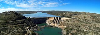
The Vanderkloof Dam is situated approximately 130 km (81 mi) downstream from Gariep Dam and is fed by the Orange River, South Africa's largest river. Vanderkloof Dam is the second-largest dam in South Africa, having the highest dam wall in the country at 108 metres (354 ft). The dam was commissioned in 1977; it has a capacity of 3,187.557 million cubic metres (2,584,195 acre⋅ft) and a surface area of 133.43 square kilometres (51.52 sq mi) when full. Other rivers flowing into this dam are the Berg River, two unnamed streams coming in from the direction of Reebokrand, the Knapsak River, Paaiskloofspruit, Seekoei River, Kattegatspruit and the Hondeblaf River, in a clockwise direction.

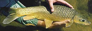
The largemouth yellowfish or Vaal-Orange largemouth yellowfish is a ray-finned fish species in the family Cyprinidae. This large freshwater barb is found in southern Africa.

The Sterkfontein Dam, located just outside the town of Harrismith, in the Free State, province of South Africa, is part of the Tugela-Vaal Water Project and the Drakensberg Pumped Storage Scheme, and located on the Nuwejaarspruit, a tributary of the Wilge River in the upper catchment area of the Vaal River. It is the second highest dam wall in South Africa and its highest earth fill dam.

The Modder River is a river in South Africa. It is a tributary of the Riet River that forms part of the border between the Northern Cape and the Free State provinces. The river's banks were the scenes of heavy fighting in the beginning of the Second Boer War at the Battle of Modder River.
Upper Orange WMA, or Upper Orange Water Management Area , Includes the following major rivers: the Modder River, Riet River, Caledon River and Orange River, and covers the following Dams:

Kalkfontein Dam is a rockfill type dam located on the Riet River, near Koffiefontein, Free State, South Africa. It was established in 1938 and renovated in 1977. The primary purpose of the dam is to serve for irrigation purposes and its hazard potential has been ranked high (3). Kalkfontein Dam reservoir is often quite low as the upstream area is hot and dry and too small to fill a dam of this size, however during flooding on the Orange River, water is transferred from the Orange River at Vanderkloof Dam to Kalkfontein Dam. In 2021 this led to the reservoir rising from 17.3% to 61.7% in a single week.
The Doring River is a river in the Western Cape Province, South Africa. It is part of the Olifants/Doring River system.
The smallmouth yellowfish is a species of ray-finned fish in the genus Labeobarbus. It has become an invasive species in rivers of the Eastern Cape, South Africa, such as the Mbhashe River.
Vanderkloof is a town in the Northern Cape province of South Africa. It is located on the Orange River and near the Rolfontein Nature Reserve.

The Vet River is a westward-flowing tributary of the Vaal River in central South Africa. Its sources are between Marquard and Clocolan and the Vet River flows roughly northwestwards to meet the Vaal at the Bloemhof Dam near Hoopstad.

The Wilge River is a tributary of the Vaal River in central South Africa. This river is important as part of the Tugela-Vaal Water Transfer Scheme where water is transferred from the Tugela River basin to the Vaal River basin.
The Mooi River is a river in North West Province, South Africa. It is a tributary of the Vaal River and belongs to the Upper Vaal Water Management Area.


