The Second Boer War, also known as the Boer War, Anglo–Boer War, or South African War, was a conflict fought between the British Empire and the two Boer republics over the Empire's influence in Southern Africa.
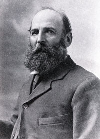
Jacobus Herculaas de la Rey, better known as Koos de la Rey, was a South African military officer who served as a Boer general during the Second Boer War. De la Rey also had a political career and was one of the leading advocates of Boer independence.

Ladysmith is a city in the Uthukela District of KwaZulu-Natal, South Africa. It lies 230 kilometres (140 mi) north-west of Durban and 365 kilometres (227 mi) south-east of Johannesburg. Important industries in the area include food processing, textiles, and tyre production. Ladysmith is the seat for both the Alfred Duma Local Municipality and Uthukela District Municipality.

The siege of Mafeking was a 217-day siege battle for the town of Mafeking in South Africa during the Second Boer War from October 1899 to May 1900. The siege received considerable attention as Lord Edward Cecil, the son of the British prime minister, was in the besieged town, as also was Lady Sarah Wilson, a daughter of the Duke of Marlborough and aunt of Winston Churchill. The siege turned the British commander, Colonel Robert Baden-Powell, into a national hero. The Relief of Mafeking, while of little military significance, was a morale boost for the struggling British.

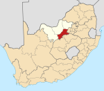
Klerksdorp is located in the North West Province, South Africa. Klerksdorp is located 165 km (103 mi) southeast of Mahikeng, the provincial capital. Klerksdorp was also the first capital of the then Transvaal Republic and used to be the home of the first Stock Exchange in the region. It became an important trading town linking Kimberley to Johannesburg. It became home to a mix of farmers, miners and immigrants servicing the two industries.

Koffiefontein is a small farming town in the Free State province of South Africa. The name means coffee fountain in Afrikaans.
Belfast is a small town in Mpumalanga Province, South Africa. It is situated in the eMakhazeni Local Municipality in the Nkangala District Municipality.
Lichtenburg is a town situated in North West Province, South Africa. It is the administrative centre of Ditsobotla Local Municipality.

Modder River is an irrigation and stock farming town situated south of Kimberley near the confluence of the Riet and Modder rivers in the Northern Cape province of South Africa.

The Imperial Yeomanry was a volunteer mounted force of the British Army that mainly saw action during the Second Boer War. Created on 2 January 1900, the force was initially recruited from the middle classes and traditional yeomanry sources, but subsequent contingents were more significantly working class in their composition. The existing yeomanry regiments contributed only a small proportion of the total Imperial Yeomanry establishment. In Ireland 120 men were recruited in February 1900. It was officially disbanded in 1908, with individual Yeomanry regiments incorporated into the new Territorial Force.

The Battle of Modder River was an engagement in the Boer War, fought at Modder River, on 28 November 1899. A British column under Lord Methuen, that was attempting to relieve the besieged town of Kimberley, forced Boers under General Piet Cronjé to retreat to Magersfontein, but suffered heavy casualties altogether.
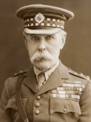
Field Marshal Paul Sanford Methuen, 3rd Baron Methuen,, was a British Army officer. He served in the Third Anglo-Ashanti War in 1873 and then in the expedition of Sir Charles Warren to Bechuanaland in the mid-1880s. He took a prominent role as General Officer Commanding the 1st Division in the Second Boer War. He suffered a serious defeat at the Battle of Magersfontein, during which he failed to carry out adequate reconnaissance and accordingly his artillery bombarded the wrong place leading to the Highland Brigade taking heavy casualties. He was later captured by the Boers at Tweebosch. After the war, he became General Officer Commanding-in-Chief in South Africa in 1908, Governor and Commander-in-Chief of Natal in 1910 and then Governor and Commander-in-Chief of Malta in 1915.
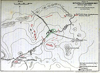
The Battle of Paardeberg or Perdeberg was a major battle during the Second Anglo-Boer War. It was fought near Paardeberg Drift on the banks of the Modder River in the Orange Free State near Kimberley.

The Battle of Magersfontein was fought on 11 December 1899, at Magersfontein, near Kimberley, South Africa, on the borders of the Cape Colony and the independent republic of the Orange Free State. British forces under Lieutenant General Lord Methuen were advancing north along the railway line from the Cape to relieve the siege of Kimberley, but their path was blocked at Magersfontein by a Boer force that was entrenched in the surrounding hills. The British had already fought a series of battles with the Boers, most recently at Modder River, where the advance was temporarily halted.

The Battle of Belmont was an engagement of the Second Boer War on 23 November 1899, where the British under Lord Methuen assaulted a Boer position on Belmont kopje.

The siege of Kimberley took place during the Second Boer War at Kimberley, Cape Colony, when Boer forces from the Orange Free State and the Transvaal besieged the diamond mining town. The Boers moved quickly to try to capture the area when war broke out between the British and the two Boer republics in October 1899. The town was ill-prepared, but the defenders organised an energetic and effective improvised defence that was able to prevent it from being taken.
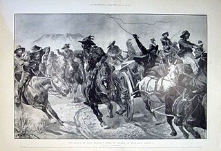
In the Battle of Tweebosch or De Klipdrift on 7 March 1902, a Boer commando led by Koos de la Rey defeated a British column under the command of Lieutenant General Lord Methuen during the final months of the Second Boer War.

42nd (Hertfordshire) Company was a unit of the Imperial Yeomanry formed to supplement the British Army in the Second Boer War. Raised by the part-time Hertfordshire Yeomanry and largely drawn from its ranks, the company was engaged at the Rhenoster River, in the Brandwater Basin, and in various small engagements round Krugersdorp. It was replaced by a new 42nd Company in 1901.

The Brandwater Basin is the drainage basin of the Brandwater River, a tributary of the Grootspruit River in the south-east of Orange Free State, South Africa, north of Lesotho. The basin is situated south of Bethlehem and south-east of Senekal, between the Witteberg to the west and north, the Rooiberge to the east, and the Drakensberg over the Caledon River to the south. It is also northwest of the Slaapkrans Basin and the Maloti Mountains on the northern border of Lesotho. Towns in the Brandwater Basin are Fouriesburg, founded in 1892, and Clarens, established in 1912.
The Battle of Hartbeesfontein, was the scene of a large skirmish during the Second Boer War which took place on February 17, 1901.