This article needs additional citations for verification .(December 2009) (Learn how and when to remove this template message) |
Makwassie | |
|---|---|
 Makwassie  Makwassie | |
| Coordinates: 27°19′S25°59′E / 27.317°S 25.983°E Coordinates: 27°19′S25°59′E / 27.317°S 25.983°E | |
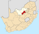
| Country | South Africa |
| Province | North West |
| District | Dr Kenneth Kaunda |
| Municipality | Maquassi Hills |
| Area | |
| • Total | 6.19 km2 (2.39 sq mi) |
| Population (2011) [1] | |
| • Total | 13,351 |
| • Density | 2,200/km2 (5,600/sq mi) |
| Racial makeup (2011) | |
| • Black African | 90.2% |
| • Coloured | 4.1% |
| • Indian/Asian | 0.7% |
| • White | 5.0% |
| • Other | 0.1% |
| First languages (2011) | |
| • Tswana | 74.4% |
| • Afrikaans | 8.2% |
| • Sotho | 7.5% |
| • Xhosa | 4.7% |
| • Other | 5.1% |
| Time zone | UTC+2 (SAST) |
| Postal code (street) | 2650 |
| PO box | 2650 |
| Area code | 018 |
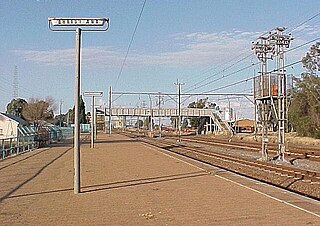
Makwassie is a small farming town situated in North West Province of South Africa that produces maize, sorghum, groundnuts and milk. The word makwassie is a corruption of the San word for an aromatic wild spearmint.

A town is a human settlement. Towns are generally larger than villages but smaller than cities, though the criteria to distinguish them vary considerably between different parts of the world.

South Africa, officially the Republic of South Africa (RSA), is the southernmost country in Africa. It is bounded to the south by 2,798 kilometres (1,739 mi) of coastline of Southern Africa stretching along the South Atlantic and Indian Oceans; to the north by the neighbouring countries of Namibia, Botswana, and Zimbabwe; and to the east and northeast by Mozambique and Eswatini (Swaziland); and it surrounds the enclaved country of Lesotho. South Africa is the largest country in Southern Africa and the 25th-largest country in the world by land area and, with over 57 million people, is the world's 24th-most populous nation. It is the southernmost country on the mainland of the Old World or the Eastern Hemisphere. About 80 percent of South Africans are of Sub-Saharan African ancestry, divided among a variety of ethnic groups speaking different African languages, nine of which have official status. The remaining population consists of Africa's largest communities of European (White), Asian (Indian), and multiracial (Coloured) ancestry.

Maize, also known as corn, is a cereal grain first domesticated by indigenous peoples in southern Mexico about 10,000 years ago. The leafy stalk of the plant produces pollen inflorescences and separate ovuliferous inflorescences called ears that yield kernels or seeds, which are fruits.
In 1822 the town was established as a mission station by Samuel Broadbent and Thomas Hodgson of the Wesleyan Missionary Society and the town was laid out in 1907.
Makwasi is a centre for maize, groundnuts, sorghum and milk production
Makwassie is located 14 kilometres (8.7 mi) south of Wolmaransstad and 78 kilometres (48 mi) north-west of Wesselsbron. It was laid out in 1907 and proclaimed in 1910. At first spelt Maquassi, it was standardized as Makwassie in 1937. The first white child in Transvaal was born there, and the first printing undertaken. [2]

Wolmaransstad is a maize-farming town situated on the N12 between Johannesburg and Kimberley in North West Province of South Africa. The town lies in an important alluvial diamond-mining area and it is the main town of the Maquassi Hills Local Municipality.

Wesselsbron is a small maize farming town 75 kilometres south of Bothaville in Free State province of South Africa.
The town claims four distinctions in Transvaal history:[ citation needed ]

The South African Republic, also referred to as the Transvaal Republic, was an independent and internationally recognised country in Southern Africa from 1852 to 1902. The country defeated the British in what is often referred to as the First Boer War and remained independent until the end of the Second Boer War on 31 May 1902, when it was forced to surrender to the British. After the war the territory of the ZAR became the Transvaal Colony.
- the first Christian mission station north of the Vaal River - built by Wesleyans Samuel Broadbent and Thomas Hogson in 1822.
- the first White person born - July 1823
- the first printed matter - a Tswana spelling book and religious tracts
- the oldest town hall - built in 1910

The Vaal River is the largest tributary of the Orange River in South Africa. The river has its source near Breyten in Mpumalanga province, east of Johannesburg and about 30 kilometres (19 mi) north of Ermelo and only about 240 kilometres (150 mi) from the Indian Ocean. It then flows westwards to its conjunction with the Orange River southwest of Kimberley in the Northern Cape. It is 1,120 kilometres (700 mi) long, and forms the border between Mpumalanga, Gauteng and North West Province on its north bank, and the Free State on its south.

Methodism, also known as the Methodist movement, is a group of historically related denominations of Protestant Christianity which derive their inspiration from the life and teachings of John Wesley. George Whitefield and John's brother Charles Wesley were also significant early leaders in the movement. It originated as a revival movement within the 18th-century Church of England and became a separate denomination after Wesley's death. The movement spread throughout the British Empire, the United States, and beyond because of vigorous missionary work, today claiming approximately 80 million adherents worldwide.

The Tswana language or Setswana is spoken in Southern Africa by about five million people. It is a Bantu language belonging to the Niger–Congo language family within the Sotho-Tswana branch of Zone S (S.30), and is closely related to the Northern and Southern Sotho languages, as well as the Kgalagadi language and the Lozi language.