Beaufort West Beaufort-Wes(in Afrikaans) eBhofolo(in Xhosa) | |
|---|---|
| Motto: Festina Lente (Latin: Make Haste Slowly) | |
 Beaufort West  Beaufort West  Beaufort West | |
| Coordinates: 32°21′S22°35′E / 32.350°S 22.583°E | |
| Country | South Africa |
| Province | Western Cape |
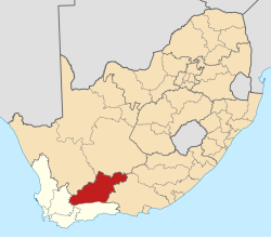
| District | Central Karoo |
| Municipality | Beaufort West |
| Established | 1818 [1] |
| Area | |
• Total | 56.5 km2 (21.8 sq mi) |
| Elevation | 900 m (3,000 ft) |
| Population (2011) [2] | |
• Total | 34,085 |
| • Density | 603/km2 (1,560/sq mi) |
| Racial makeup (2011) | |
| • Black African | 7.25% |
| • Coloured | 77.92% |
| • Indian/Asian | 0.53% |
| • White | 13.66% |
| • Other | 0.64% |
| First languages (2011) | |
| • Afrikaans | 91.48% |
| • Xhosa | 3.59% |
| • English | 2.47% |
| • Other | 2.46% |
| Time zone | UTC+2 (SAST) |
| Postal code (street) | 6970 |
| PO box | 6970 |
| Area code | 023 |
| Website | www |


Beaufort West (Afrikaans: Beaufort-Wes; Xhosa: eBhobhofolo) is a town in the Western Cape province in South Africa. It is the largest town in the arid Great Karoo region, and is known as the "Capital of the Karoo". It forms part of the Beaufort West Local Municipality, with 34,085 inhabitants in 2011. [3]
Contents
It is the centre of an agricultural district based mainly on sheep farming, and is a significant town and logistical support hub on the N1 national road.
Next door to Beaufort West is the Karoo National Park. Important Permian fossils have been found in the area to the west of the town. [4] These were initially found by David Baird, son of the local magistrate in 1827. The old Town Hall and the Dutch Reformed Church have been declared national monuments.