Beaufort West Local Municipality

Last updated

Beaufort West
Beaufort-Wes
Beaufort West CoA.png
Map of the Western Cape with Beaufort West highlighted.svg
Location of Beaufort West Local Municipality within the Western Cape
Coordinates: 32°20′S22°45′E / 32.333°S 22.750°E / -32.333; 22.750
Country South Africa
Province Western Cape
District Central Karoo
Seat Beaufort West
Wards 7
Government
[1]
  Type Municipal council
  MayorGeorgina Juliana Duimpies (DA)
  Deputy Mayor[Vacant] (DA)
  SpeakerElvico Links (DA)
Area
  Total
21,917 km2 (8,462 sq mi)
Population
 (2022) [2]
  Total
72,972
  Density3.3/km2 (8.6/sq mi)
Racial makeup (2022)
[2]
   Africans 15.7%
   Coloured 77.5%
   Indian/Asian 0.4%
   White 5.0%
First languages (2011)
[3]
   Afrikaans 84.3%
   Xhosa 10.7%
   English 2.5%
  Other2.5%
Time zone UTC+2 (SAST)
Municipal codeWC053

Beaufort West Municipality (Afrikaans : Beaufort-Wes Munisipaliteit; Xhosa : uMasipala wase Bhobhofolo) is a local municipality located in the Western Cape province of South Africa. As of 2011, the population is 49,586. [3] Its municipality code is WC053.

Contents

Geography

The municipality covers an area of 21,917 square kilometres (8,462 sq mi), making it the largest local municipality in the Western Cape and the sixth-largest in South Africa. It is located in the furthest northeastern part of the province in the Great Karoo. It abuts on the Karoo Hoogland Municipality to the northwest, the Ubuntu Municipality to the north, the Dr Beyers Naudé Municipality to the southeast, the Prince Albert Municipality to the south and the Laingsburg Municipality to the southwest.

Demographics

At the time of the South African National Census of 2022, the population of the municipality was 72,972 people, a 47.2% increase from 2011. 77.5% of the population identified as "Coloured," 15.7% as "Black African," and 5% White. [4]

According to the 2011 census the municipality has a population of 49,586 people in 13,089 households. Of this population, 73.5% describe themselves as "Coloured", 16.3% as "African", and 9.2% as "White". The first language of 84.3% of the population is Afrikaans, while 10.7% speak Xhosa and 2.5% speak English. [5]

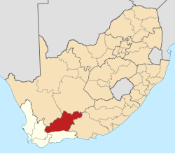
The main town in the municipality is Beaufort West, which as of 2011 has a population of 34,085. [6] Murraysburg (pop. 5,069) [7] is situated in the far east of the municipality. Nelspoort (pop. 1,699) is situated northeast of Beaufort West, while Merweville (pop. 1,592) is in the far west of the municipality.

History

At the end of the apartheid era, the area that is today the Beaufort West Local Municipality was divided between two Regional Services Councils (RSCs): the western part around Beaufort West formed part of the Central Karoo RSC, while the eastern part around Murraysburg formed part of the Kamdeboo RSC. The towns of Beaufort West and Murraysburg were governed by municipal councils elected by their white residents, while the coloured residents of the towns were governed by management committees subordinate to the white councils. Kwa-Mandlenkosi was governed by a town council established under the Black Local Authorities Act, 1982.

After the national elections of 1994 a process of local government transformation began, in which negotiations were held between the existing local authorities, political parties, and local community organisations. As a result of these negotiations, the existing local authorities were dissolved and transitional local councils (TLCs) were created for each town and village. In December 1994 the Beaufort West TLC replaced the Municipality of Beaufort West, Beaufort West Management Committee and Kwa-Mandlenkosi Town Council. In January 1994 the Murraysburg TLC replaced the Municipality of Murraysburg and Murraysburg Management Committee. In June 1995 the Murraysburg district was removed from the Kamdeboo RSC and added to the Central Karoo RSC.

The transitional councils were initially made up of members nominated by the various parties to the negotiations, until May 1996 when elections were held. At these elections the Central Karoo District Council was established, replacing the Central Karoo RSC. Transitional representative councils (TRCs) were also elected to represent rural areas outside the TLCs on the District Council; the area that was to become Beaufort West Local Municipality included Beaufort West and Murraysburg TRCs.

At the local elections of December 2000 the transitional councils were dissolved. The Central Karoo District Council was replaced by the Central Karoo District Municipality. The Beaufort West Local Municipality was established as a single local authority covering the area of the Beaufort West TLC and TRC, except for the Karoo National Park which became a District Management Area (DMA). The area of the Murraysburg TLC and TRC also became a DMA. In 2011 DMAs were abolished and these areas were included into the Beaufort West Local Municipality.

Politics

The municipal council consists of thirteen members elected by mixed-member proportional representation. Seven councillors are elected by first-past-the-post voting in seven wards, while the remaining six are chosen from party lists so that the total number of party representatives is proportional to the number of votes received. In the election of 1 November 2021 no party obtained a majority of seats on the council. The African National Congress (ANC) has formed a coalition with the Patriotic Alliance (PA) and the Karoo Democratic Force (KDF) to govern the municipality. [8]

The following table shows the results of the 2021 election. [9]

Beaufort West local election, 1 November 2021
PartyVotesSeats
WardListTotal%WardListTotal
African National Congress 4,2994,2378,53628.3%404
Democratic Alliance 4,2123,9638,17527.1%134
Patriotic Alliance 3,2983,3146,61221.9%213
Good 1,5961,8693,46511.5%011
Karoo Democratic Force8458251,6705.5%011
Independent candidates 70700.2%00
5 other parties7888411,6295.4%000
Total15,10815,04930,1577613
Valid votes15,10815,04930,15798.3%
Spoilt votes 3151985131.7%
Total votes cast15,42315,24730,670
Voter turnout15,486
Registered voters26,878
Turnout percentage57.6%

Following a series of byelections, the DA now has a majority of seats on the municipal council. The current composition of the council as of 20 June 2024 is as follows: DA 7, ANC 3, PA 1, KDF 1, Good 1. [10]

References

  1. "Contact list: Executive Mayors". Government Communication & Information System. Archived from the original on 14 July 2010. Retrieved 27 July 2014.
  2. 1 2 "Beaufort West (Local Municipality, South Africa)". Population Statistics, Charts, Map and Location. 2 February 2022. Retrieved 9 August 2024.
  3. 1 2 "Statistics by place". Statistics South Africa. Retrieved 27 September 2015.
  4. "Beaufort West (Local Municipality, South Africa) - Population Statistics, Charts, Map and Location".
  5. "Beaufort West Local Municipality". Census 2011.
  6. Sum of the Main Places Beaufort West, New Town, Kwa-Mandlenkosi and Rustdene from Census 2011.
  7. Sum of the Main Places Murraysburg and Rooivlakte from Census 2011.
  8. "Meet Western Cape's youngest mayor". iol.co.za. Retrieved 17 November 2021.
  9. "Election Result Table for LGE2021 – Beaufort West". wikitable.frith.dev. Retrieved 8 November 2021.
  10. Sussman, Wayne (20 June 2024). "DA snatches outright control of Beaufort West, crushes competition in Cape Town wards". Daily Maverick. Retrieved 19 July 2024.