Kannaland Local Municipality

Last updated
Kannaland
Kannaland CoA.png
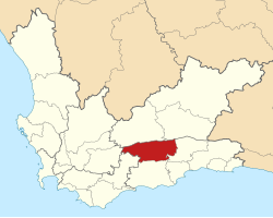
Map of the Western Cape with Kannaland highlighted.svg
Location of Kannaland Local Municipality within the Western Cape
Coordinates: 33°40′S21°15′E / 33.667°S 21.250°E / -33.667; 21.250 Coordinates: 33°40′S21°15′E / 33.667°S 21.250°E / -33.667; 21.250
Country South Africa
Province Western Cape
District Garden Route
Seat Ladismith
Wards 4
Government
[1]
  Type Municipal council
  MayorJeffrey Donson (ICOSA)
Area
  Total4,758 km2 (1,837 sq mi)
Population
 (2011) [2]
  Total24,767
  Density5.2/km2 (13/sq mi)
Racial makeup (2011)
[2]
   Black African 4.7%
   Coloured 84.6%
   Indian/Asian 0.3%
   White 9.9%
First languages (2011)
[2]
   Afrikaans 95.4%
   English 2.5%
  Other2.1%
Time zone UTC+2 (SAST)
Municipal codeWC041

Kannaland Municipality (Afrikaans : Kannaland Munisipaliteit) is a local municipality located within the Garden Route District Municipality in the Western Cape province of South Africa. The municipal area is situated in the western part of the Little Karoo and includes the towns of Ladismith, Calitzdorp and Zoar. As of 2011 it has a population of 24,767. [2] Its municipality code is WC041.

Contents

Geography

The municipality covers an area of 4,758 square kilometres (1,837 sq mi) in the Little Karoo, stretching from the Swartberg in the north to the Langeberg in the south, and from the Anysberg in the west to the Gamkaberg in the east. It is drained by the Groot River and the Gourits River. It abuts on the Laingsburg and Prince Albert municipalities to the north, the Oudtshoorn Municipality to the east, the Hessequa Municipality to the south and the Swellendam and Langeberg Municipalities to the west.

According to the 2011 census the municipality has a population of 24,767 people in 6,212 households. Of this population, 84.6% describe themselves as "Coloured", 9.9% as "White", and 4.7% as "Black African". The first language of 95.4% of the population is Afrikaans, while 2.5% speak English. [3]

The largest town and location of the municipal headquarters is Ladismith, which as of 2011 has a population of 7,127. [4] Ladismith is at the foot of the Swartberg, as are Zoar (pop. 4,659) and Calitzdorp (pop. 4,284) to the east. Van Wyksdorp (pop. 833) is further south in the valley of the Groot River.

History

Formation of the municipality

At the end of the apartheid era, the area that is today the Kannaland Municipality was divided between two Regional Services Councils (RSCs): the northern part around Ladismith, Zoar and Calitzdorp formed part of the Klein Karoo RSC, while the southern part around Van Wyksdorp formed part of the South Cape RSC. The towns of Ladismith, Calitzdorp and Van Wyksdorp were governed by municipal councils elected by their white residents. The coloured residents of Nissenville (Ladismith) and Calitzdorp were governed by management committees subordinate to the white councils. The mission settlement of Zoar was governed by a board of management.

While the negotiations to end apartheid were taking place a process was established for local authorities to agree on voluntary mergers. In November 1993, the Municipality of Calitzdorp and the Calitzdorp Management Committee merged into a single municipal council.

After the national elections of 1994 a process of local government transformation began, in which negotiations were held between the existing local authorities, political parties, and local community organisations. As a result of these negotiations, the existing local authorities were dissolved and transitional local councils (TLCs) were created for each town and village. In December 1994 Ladismith TLC replaced the Municipality of Ladismith and the Nissenville Management Committee. In January 1995 Calitzdorp TLC replaced the Municipality of Calitzdorp, and Zoar TLC replaced the Zoar Management Board. In October 1995 Vanwyksdorp Municipality was also converted into a TLC.

The transitional councils were initially made up of members nominated by the various parties to the negotiations, until May 1996 when elections were held. At these elections the Regional Services Councils were replaced by District Councils (DCs), and transitional representative councils (TRCs) were elected to represent rural areas outside the TLCs on the DCs. The area that is today Kannaland included the Ladismith and Calitzdorp TRCs under the Klein Karoo DC as well as part of the Langeberg TRC under the South Cape DC.

At the local elections of December 2000 the TLCs and TRCs were dissolved and the Kannaland Municipality was established as a single local authority. At the same election the Klein Karoo and South Cape District Councils were also dissolved and replaced by the Eden District Municipality.

Political history since 2000

The December 2000 local government elections returned a council of four Democratic Alliance (DA) councillors, four African National Congress (ANC) councillors, and one Pan Africanist Congress (PAC) councillor. [5] A short-lived coalition led by the DA took power after the December 2000 local government elections, but it collapsed when the single PAC councillor withdrew his support, and the ANC took control of the council in March 2001.

The March 2006 local government elections returned a council of four ANC councillors, two DA councillors, two Independent Civic Organisation of South Africa (ICOSA) councillors, and one Independent Democrats (ID) councillor. [6] An ANC/DA coalition took power until this coalition collapsed in August 2006 and was replaced by a coalition between the DA and ICOSA. This coalition collapsed in September 2007 when two ICOSA and three ANC councillors crossed the floor to the new National People's Party (NPP), giving that party a majority of five seats in a council which at that time consisted of nine members. The DA refused to recognize the new NPP-led council administration as it alleged that the 2 ICOSA defectors were sacked prior to the floor-crossing window being open, and it challenged the council recomposition in the Western Cape High Court. The former mayor refused to step down pending the outcome of the case.

In 2011 the auditor-general declared that he could not give a clear statement about the financial situation in the municipality because the records are missing and no one seemed to know where they were. [7] After almost a decade of financial problems an attempt to restore order was underway in 2011 [8]

In the election of 18 May 2011 the council was reduced in size to seven seats. No party obtained a majority; ICOSA won three seats while the ANC and the DA won two each. [9] ICOSA and the ANC formed a coalition to govern the municipality. [10]

The election of 3 August 2016 left the party composition of the council unchanged. [11] The DA and ANC councillors formed a coalition to govern without ICOSA, [12] but DA national leadership said that the coalition had not been authorized. [13] In March 2017 the ANC recalled its councillors to put an end to the coalition. [14] However the mayor has not been recalled despite the national ANC structures stating that this would happen. A motion of no confidence in the mayor and speaker of the municipality was put forward in August 2017. The motion failed with the DA and ANC in the municipality against the motion, leaving the ANC mayor Magdalene Barry in power. [15] The Democratic Alliance spokesperson on local government stated that the party would side with the ANC in order to keep the Independent Civic Organisation away from the public purse. This follows forensic evidence detailing financial misconduct that amounted to more than R14 million under Jeffrey Donson's tenure. [16]

Politics

The municipal council consists of seven members elected by mixed-member proportional representation. Four councillors are elected by first-past-the-post voting in four wards, while the remaining three are chosen from party lists so that the total number of party representatives is proportional to the number of votes received.

Election results

The following table shows the results of the 2021 election. [17]

Kannaland local election, 1 November 2021
PartyVotesSeats
WardListTotal %WardListTotal
Independent Civic Organisation of South Africa 4,0634,0468,10945.2%303
African National Congress 1,9521,9083,86021.5%022
Democratic Alliance 1,8381,8443,68220.5%101
Kannaland Independent Party6576861,3437.5%011
6 other parties4864609465.3%000
Total8,9968,94417,940437
Valid votes8,9968,94417,94099.0%
Spoilt votes 97911881.0%
Total votes cast9,0939,03518,128
Voter turnout9,107
Registered voters14,937
Turnout percentage61.0%

Related Research Articles

Knysna Local Municipality Local municipality in Western Cape, South Africa

Knysna Local Municipality is a municipality part of Garden Route District Municipality located in the Western Cape Province of South Africa. As of 2011 the population is 68,659. Its municipal code is WC048.

Stellenbosch Local Municipality Local municipality in Western Cape, South Africa

Stellenbosch Local Municipality is the local municipality that governs the towns of Stellenbosch, Franschhoek and Pniel, and the surrounding rural areas, in the Western Cape province of South Africa. It covers an area of 831 square kilometres (321 sq mi) and, as of 2011, had a population of 155,733 people in 43,420 households. It falls within the Cape Winelands District Municipality.

George Local Municipality Local municipality in Western Cape, South Africa

George Municipality is a municipality located in the Western Cape Province of South Africa. As of 2011 the population is 193,672. Its municipality code is WC044.

Mossel Bay Local Municipality Local municipality in Western Cape, South Africa

Mossel Bay Municipality is a municipality located in the Western Cape Province of South Africa. As of 2011 the population was 89,430.

Witzenberg Local Municipality Local municipality in Western Cape, South Africa

Witzenberg Municipality is a local municipality located within the Cape Winelands District Municipality, in the Western Cape province of South Africa. As of 2011 it had a population of 115,946.

Bitou Local Municipality Local municipality in Western Cape, South Africa

Bitou Local Municipality is a municipality part of Garden Route District Municipality located in the Western Cape Province of South Africa. Its municipality code is WC047.

Langeberg Local Municipality Local municipality in Western Cape, South Africa

Langeberg Municipality is a local municipality located within the Cape Winelands District Municipality in the Western Cape province of South Africa. As of 2011 it had a population of 97,724. Its municipality code is WC026.

Beaufort West Local Municipality Local municipality in Western Cape, South Africa

Beaufort West Local Municipality is a municipality located in Western Cape Province, South Africa. As of 2011 the population is 49,586. Its municipality code is WC053.

Oudtshoorn Local Municipality Local municipality in Western Cape, South Africa

Oudtshoorn Municipality is a municipality located in the Western Cape Province of South Africa. As of 2011 the population was 95,933.

Overstrand Local Municipality Local municipality in Western Cape, South Africa

Overstrand Municipality is a local municipality in the Western Cape province of South Africa. It is located along the Atlantic coast between Cape Town and Cape Agulhas, within the Overberg District Municipality. The principal towns in the municipality are Hermanus, Gansbaai and Kleinmond. As of 2011 it had a population of 80,432.

Cape Winelands District Municipality District municipality in Western Cape, South Africa

The Cape Winelands District Municipality, formerly the Boland District Municipality, is a district municipality located in the Boland region of the Western Cape province of South Africa. As of 2011, it had a population of 787,490. The largest towns in the municipality are Paarl, Worcester, Stellenbosch and Wellington.

Breede Valley Local Municipality Local municipality in Western Cape, South Africa

Breede Valley Municipality is a local municipality located within the Cape Winelands District Municipality, in the Western Cape province of South Africa. As of 2007, it had a population of 166,825. Its municipality code is WC025.

Cape Agulhas Local Municipality Local municipality in Western Cape, South Africa

Cape Agulhas Municipality is a municipality located in the Western Cape Province of South Africa. As of 2011 it had a population of 33,038. Its municipality code is WC033. It is named after Cape Agulhas, the southernmost point of Africa. The largest town is Bredasdorp, which is the seat of the municipal headquarters. It also includes the villages of Napier, Struisbaai, Elim, Arniston and L'Agulhas, and the De Hoop Nature Reserve.

Cederberg Local Municipality Local municipality in Western Cape, South Africa

Cederberg Local Municipality is a local municipality which governs an area of the Western Cape province of South Africa stretching from the Cederberg mountains through the middle valley of the Olifants River to the Atlantic coast. It includes the towns of Clanwilliam, Citrusdal and Lamberts Bay, and the surrounding villages and farms. As of 2011 it had a population of 49,768. It is located within the West Coast District Municipality and has municipality code WC012.

Laingsburg Local Municipality Local municipality in Western Cape, South Africa

Laingsburg Municipality is a municipality located in the Western Cape Province of South Africa. As of 2011 the population is 8,289. Its municipality code is WC051.

Hessequa Local Municipality Local municipality in Western Cape, South Africa

Hessequa Local Municipality is a municipality located in the Western Cape Province of South Africa. It is flanked by the lower Breede River to the west and the Gourits River to the east. As of 2011 the population was 52,642. Its municipality code is WC042. The name Hessequa, meaning "people of the trees", refers to the tribe of indigenous Khoikhoi people.

Swellendam Local Municipality Local municipality in Western Cape, South Africa

Swellendam Municipality is a municipality located in the Western Cape Province of South Africa. As of 2011 it had a population of 35,916. Its municipality code is WC034.

Theewaterskloof Local Municipality Local municipality in Western Cape, South Africa

Theewaterskloof Municipality is a local municipality located within the Overberg District Municipality, in the Western Cape province of South Africa. As of 2007, the population was 108,790. Its municipality code is WC031. The enormous Theewaterskloof Dam, which provides water for Cape Town and the surrounding areas, is located in this municipality.

Garden Route District Municipality District municipality in Western Cape, South Africa

The Garden Route District Municipality is a district municipality located in the Western Cape Province of South Africa. Its municipality code is DC4.

The Independent Civic Organisation of South Africa (ICOSA) is a minor South African political party. It was founded by former Karoo District Municipality manager Truman Prince, who was expelled from the African National Congress (ANC) in 2006. He was reinstated as municipal manager by the municipal council in June, 2007, after a protracted legal battle, but was fired from his post in August of that same year through provincial vote. Convicted child rapist Jeffrey Donson, formerly of the National People's Party (NPP), is the current president of ICOSA.

References

  1. "Contact list: Executive Mayors". Government Communication & Information System. Archived from the original on 14 July 2010. Retrieved 22 February 2012.
  2. 1 2 3 4 "Statistics by place". Statistics South Africa. Retrieved 27 September 2015.
  3. "Kannaland Local Municipality". Census 2011.
  4. Sum of the Main Places Ladismith and Nissenville from Census 2011.
  5. https://www.elections.org.za/content/LGEPublicReports/2/Seat%20Calculation%20Detail/WP/WC041.pdf [ bare URL PDF ]
  6. https://www.elections.org.za/content/LGEPublicReports/95/Seat%20Calculation%20Detail/WP/WC041.pdf [ bare URL PDF ]
  7. Die Burger June 8 2011 (in Afrikaans)
  8. Die Bruger June 8 2011 (in Afrikaans)
  9. https://www.elections.org.za/content/LGEPublicReports/197/Seat%20Calculation%20Detail/WP/WC041.pdf [ bare URL PDF ]
  10. "Political composition of councils" (PDF). Western Cape Department of Local Government. August 2012. Retrieved 17 August 2012.
  11. https://www.elections.org.za/content/LGEPublicReports/402/Seat%20Calculation%20Detail/WP/WC041.pdf [ bare URL PDF ]
  12. Le Roux, Ilze-Marie (17 August 2016). "DA, ANC vote out Icosa in Kannaland municipality". EWN. Retrieved 4 June 2017.
  13. du Plessis, Carien (18 August 2016). "DA to discipline Kannaland councillors". News24. Retrieved 4 June 2017.
  14. de Villiers, James (9 March 2017). "ANC recalls Kannaland mayor to end coalition with DA". News24. Retrieved 4 June 2017.
  15. Dentlinger, Lindsay (10 August 2017). "No Confidence Motion to Remove Kannaland speaker, mayor fails". Eyewitness News. Retrieved 12 August 2017.
  16. Dentlinger, Lindsay (11 August 2017). "DA ANC Councillors to Stand Together in Kannaland". Eyewitness News. Retrieved 12 August 2017.
  17. "Election Result Table for LGE2021 — Kannaland". wikitable.frith.dev. Retrieved 2021-11-08.