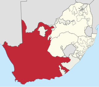
The Province of the Cape of Good Hope, commonly referred to as the Cape Province and colloquially as The Cape, was a province in the Union of South Africa and subsequently the Republic of South Africa. It encompassed the old Cape Colony, as well as Walvis Bay, and had Cape Town as its capital. In 1994, the Cape Province was divided into the new Eastern Cape, Northern Cape and Western Cape provinces, along with part of the North West.

The Western Cape is a province of South Africa, situated on the south-western coast of the country. It is the fourth largest of the nine provinces with an area of 129,449 square kilometres (49,981 sq mi), and the third most populous, with an estimated 7 million inhabitants in 2020. About two-thirds of these inhabitants live in the metropolitan area of Cape Town, which is also the provincial capital. The Western Cape was created in 1994 from part of the former Cape Province. The two largest cities are Cape Town and George.

Mossel Bay is a harbour town of about 120,000 people on the Southern Cape of South Africa. It is an important tourism and farming region of the Western Cape Province. Mossel Bay lies 400 kilometres east of the country's seat of parliament, Cape Town, and 400 km west of Port Elizabeth, the largest city in the Eastern Cape. The older parts of the town occupy the north-facing side of the Cape St Blaize Peninsula, whilst the newer suburbs straddle the Peninsula and have spread eastwards along the sandy shore of the Bay.

Lieutenant-General Sir Henry George Wakelyn Smith, 1st Baronet, GCB was a notable English soldier and military commander in the British Army of the early 19th century. A veteran of the Napoleonic Wars, he is also particularly remembered for his role in the Battle of Aliwal, India in 1846, his subsequent governorship of the Cape Colony, and as the husband of Lady Smith.

Overberg is a region in South Africa to the east of Cape Town beyond the Hottentots-Holland mountains. It lies along the Western Cape Province's south coast between the Cape Peninsula and the region known as the Garden Route in the east. The boundaries of the Overberg are the Hottentots-Holland mountains in the West; the Riviersonderend Mountains, part of the Cape Fold Belt, in the North; the Atlantic and Indian Oceans in the South and the Breede River in the East.
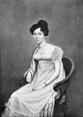
Juana María de los Dolores de León Smith, commonly known as Lady Smith, was the wife of General Sir Harry Smith, Governor of the Cape Colony.

Kannaland Municipality is a local municipality located within the Garden Route District Municipality, in the Western Cape province of South Africa. The municipal area is situated in the western part of the Little Karoo and includes the towns of Ladismith, Calitzdorp and Zoar. As of 2011, it has a population of 24,767. Its municipality code is WC041.

The Swartberg mountains are a mountain range in the Western Cape province of South Africa. It is composed of two main mountain chains running roughly east–west along the northern edge of the semi-arid Little Karoo. To the north of the range lies the other large semi-arid area in South Africa, the Great Karoo. Most of the Swartberg Mountains are above 2000 m high, making them the tallest mountains in the Western Cape. It is also one of the longest, spanning some 230 km from south of Laingsburg in the west to between Willowmore and Uniondale in the east. Geologically, these mountains are part of the Cape Fold Belt.
Pinelands is an affluent garden city suburb located on the edge of the southern suburbs of Cape Town, South Africa, neighbouring the suburb of Thornton, and is known for its large thatched houses and green spaces. The suburb is primarily residential and is often praised for its peacefulness and abundance of trees. Pinelands is one of the few areas in Cape Town in which sale of alcohol to the public is prohibited, but some clubs have private liquor licenses. It is a popular place for senior citizens to retire to. While there are several retirement homes in the suburb, younger people are increasingly moving in.

The Langeberg Range is a mountain range in the Western Cape province of South Africa. Its highest peak is Keeromsberg at 2,075 m that lies 15 km northeast of the town of Worcester. Some of the highest peaks of the range are located just to the north of Swellendam, in a subrange known as the Clock Peaks whose highest point is the 1,710 m high Misty Point. Local lore states one can tell the time by means of the shadows cast by the seven summits of the Clock Peaks.

Wynberg is a southern suburb of the City of Cape Town in Western Cape, South Africa. It is situated between Plumstead and Kenilworth, and is a main transport hub for the Southern Suburbs of Cape Town.

The City of Cape Town is the local government of Cape Town and surrounding areas. As of the 2016 community survey, it had a population of 4,005,016.

The Anysberg Nature Reserve of 62,500 ha, is situated in the western Little Karoo region of the Gouritz Cluster Biosphere Reserve in the Western Cape province, South Africa. The central mountain is named after Anise, Pimpinella anisum, which is found in the reserve. The reserve was established in 1984, to conserve succulent and fynbos flora in the Cape Fold Belt, and to reintroduce game which formerly occurred here.

Touws River is a small railway town of 8,126 people in the Western Cape province of South Africa. It is located on the river of the same name, about 160 kilometres (100 mi) north-east of Cape Town. The Touwsrivier CPV Solar Project is located just outside of the town and supplies 50 MW to the national electrical grid.
Zoar is a settlement in Garden Route District Municipality in the Western Cape province of South Africa.

The South African Railways Class 7E 4-8-0 of 1899 was a steam locomotive from the pre-Union era in the Cape of Good Hope.
The National People's Party was a political party registered on a national level with the Independent Electoral Commission (IEC) of South Africa. It came into existence when Badih Chaaban, a member of the Cape Town City Council crossed the floor from the Africa Muslim Party (AMP) in an attempt to wrest control of the city council from the Democratic Alliance-led multi-party coalition. The party was set up by Chaaban shortly before the floor crossing period in 2007 with the help of David Sasman, its interim leader. It should not be confused with the National People's Party, renamed the Minority Front, led by Amichand Rajbansi during the apartheid era.

Mamre is a small rural town in the Western Cape province of South Africa. It is situated on the northernmost border of the City of Cape Town Metropolitan Municipality. It is situated approximately 55 kilometres (30 mi) north of central Cape Town, and 5–6 km to the neighbouring industrial town of Atlantis.
Vanwyksdorp is a town in Kannaland Local Municipality in the Western Cape province of South Africa. Village on the Groot River, some 55 km south-east of Ladismith and 66 km north-east of Riversdale.

The Garcia's Pass is a mountain pass across the Langeberg in the Western Cape province of South Africa, with its highest point at 548 m (1,798 ft) altitude. The regional road numbered R323 uses this pass on its leg between Riversdale in the south and Ladismith in the Little Karoo to the north. From Riversdale, the road winds to the Garcia Pass across the Langeberg to Muiskraal in the northern foothills. The maximum slope is 1:14 on the southern descend.


