
Cape Breton Island is a rugged and irregularly shaped island on the Atlantic coast of North America and part of the province of Nova Scotia, Canada.
The written history of the Cape Colony in what is now South Africa began when Portuguese navigator Bartolomeu Dias became the first modern European to round the Cape of Good Hope in 1488. In 1497, Vasco da Gama sailed along the whole coast of South Africa on his way to India, landed at St Helena Bay for 8 days, and made a detailed description of the area. The Portuguese, attracted by the riches of Asia, made no permanent settlement at the Cape Colony. However, the Dutch East India Company (VOC) settled the area as a location where vessels could restock water and provisions.
The Anglo-Dutch Treaty of 1814 was signed by the United Kingdom of Great Britain and Ireland and the Sovereign Principality of the United Netherlands in London on 13 August 1814.
Narsarmijit, formerly Narsaq Kujalleq and Frederiksdal, is a settlement in southern Greenland. It is located in the Kujalleq municipality near Cape Thorvaldsen. Its population was 66 in 2020. There has been a slow but steady pattern of emigration since the late 1950s.

Crossroads is a high-density township in the Western Cape, South Africa.

Cape Verde or Cabo Verde, officially the Republic of Cabo Verde, is an archipelago and island country of West Africa in the central Atlantic Ocean, consisting of ten volcanic islands with a combined land area of about 4,033 square kilometres (1,557 sq mi). These islands lie between 600 and 850 kilometres west of Cap-Vert, the westernmost point of continental Africa. The Cape Verde islands form part of the Macaronesia ecoregion, along with the Azores, the Canary Islands, Madeira, and the Savage Isles.

Joe Slovo is an informal settlement in Langa, Cape Town. Like many other informal settlements, it was named after former housing minister and anti-Apartheid activist, Joe Slovo. With over 20,000 residents, Joe Slovo is one of the largest informal settlements in South Africa.
The Cape Hope Islands are an uninhabited Canadian arctic islands group located within the midsection of James Bay in Nunavut, Canada. They are situated south of Vieux-Comptoir.

Symphony Way Temporary Relocation Area in Delft, Cape Town, better known by its nickname Blikkiesdorp, is a relocation camp made-up of corrugated iron shacks. Blikkiesdorp, which is Afrikaans for "Tin Can Village", was given its name by residents because of the row-upon-row of tin-like one room structures throughout the settlement.
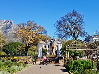
The Company's Garden is the oldest garden in South Africa, a park and heritage site located in central Cape Town. The garden was originally created in the 1650s by the region's first European settlers and provided fertile ground to grow fresh produce to replenish ships rounding the Cape. It is watered from the Molteno Dam, which uses water from the springs on the lower slopes of Table Mountain.

Founded in 2008, the Social Justice Coalition (SJC) is a membership-based social movement made up of 12 branches, located mainly in informal settlements across Khayelitsha, Cape Town. Since its formation, the SJC has worked to advance the constitutional rights to life, dignity, equality, freedom and safety for all people, but especially those living in informal settlements across South Africa. Their campaigns are based on ongoing research, education, and advocacy and divided across two programs. The Local Government Program leads the work on sanitation, budgets, and urban land. The Safety and Justice Program is focused on policing and the criminal justice system.
QQ Section also known as Tambo Park, was founded in 1989 and is an Informal Settlement in the Site B sub-division of Khayelitsha in South Africa.
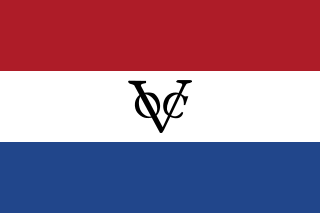
The Cape Colony was a Dutch United East India Company (VOC) colony in Southern Africa, centered on the Cape of Good Hope, from where it derived its name. The original colony and the successive states that the colony was incorporated into occupied much of modern South Africa. Between 1652 and 1691, it was a Commandment, and between 1691 and 1795, a Governorate of the VOC. Jan van Riebeeck established the colony as a re-supply and layover port for vessels of the VOC trading with Asia. The Cape came under VOC rule from 1652 to 1795 and from 1803 to 1806 was ruled by the Batavian Republic. Much to the dismay of the shareholders of the VOC, who focused primarily on making profits from the Asian trade, the colony rapidly expanded into a settler colony in the years after its founding.

Macassar Dunes Conservation Area is a 1,116-hectare (2,760-acre) coastal nature reserve in Macassar, within the City of Cape Town, South Africa.

Aphrodisias, sometimes called Aphrodisias of Cilicia to distinguish it from the town of the same name in Caria, was a port city of ancient Cilicia whose ruins now lie near Cape Tisan in Mersin Province, Turkey.

Cape Verde was a colony of the Portuguese Empire from the initial settlement of the Cape Verde Islands in 1462 until the independence of Cape Verde in 1975.

Slavery in South Africa existed from 1653 in the Dutch Cape Colony until the abolition of slavery in the British Cape Colony on 1 January 1834. This followed the British banning the trade of slaves between colonies in 1807, with their emancipation by 1834. Beyond legal abolition, slavery continued in the Transvaal though a system of inboekstelsel.
General elections will be held in South Africa in 2024 to elect a new National Assembly as well as the provincial legislature in each province. These will be the seventh general election held under the conditions of universal adult suffrage since the end of the apartheid era in 1994. The new National Council of Provinces will be elected at the first sitting of each provincial legislature. Ever since the first post-apartheid election in 1994, the African National Congress has held a majority of seats in the National Assembly.
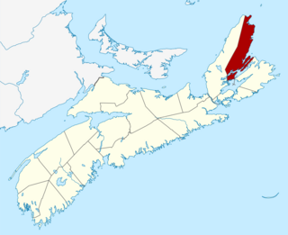
The Municipality of the County of Victoria is a county municipality on Cape Breton Island, Nova Scotia, Canada. It provides local government to about 7,000 residents of the eponymous historical county except for the Wagmatcook 1 reserve. The municipal offices are in the village of Baddeck.


