Karatara

Last updated
Karatara
South Africa Western Cape location map.svg
Red pog.svg
Karatara
South Africa adm location map.svg
Red pog.svg
Karatara
Coordinates: 33°54′00″S22°48′58″E / 33.9°S 22.816°E / -33.9; 22.816 Coordinates: 33°54′00″S22°48′58″E / 33.9°S 22.816°E / -33.9; 22.816
Country South Africa
Province Western Cape
District Garden Route
Municipality Knysna
Area
[1]
  Total5.82 km2 (2.25 sq mi)
Population
(2011) [1]
  Total880
  Density150/km2 (390/sq mi)
Racial makeup (2011)
[1]
   Black African 2.8%
   Coloured 56.5%
   White 40.1%
  Other0.6%
First languages (2011)
[1]
   Afrikaans 95.1%
   English 2.5%
  Other2.4%
Time zone UTC+2 (SAST)
Postal code (street)
6580
PO box
6580
Area code 044

Karatara is a town in Knysna Local Municipality in the Western Cape province of South Africa.

Knysna Local Municipality Local municipality in Western Cape, South Africa

Knysna Local Municipality is a municipality part of Garden Route District Municipality located in the Western Cape Province of South Africa. As of 2011 the population is 68,659. Its municipal code is WC048.

Western Cape Province of South Africa on the south-western coast

The Western Cape is a province of South Africa, situated on the south-western coast of the country. It is the fourth largest of the nine provinces with an area of 129,449 square kilometres (49,981 sq mi), and the third most populous, with an estimated 6.6 million inhabitants in 2018. About two-thirds of these inhabitants live in the metropolitan area of Cape Town, which is also the provincial capital. The Western Cape was created in 1994 from part of the former Cape Province.

South Africa Republic in the southernmost part of Africa

South Africa, officially the Republic of South Africa (RSA), is the southernmost country in Africa. It is bounded to the south by 2,798 kilometres (1,739 mi) of coastline of Southern Africa stretching along the South Atlantic and Indian Oceans; to the north by the neighbouring countries of Namibia, Botswana, and Zimbabwe; and to the east and northeast by Mozambique and Eswatini (Swaziland); and it surrounds the enclaved country of Lesotho. South Africa is the largest country in Southern Africa and the 25th-largest country in the world by land area and, with over 57 million people, is the world's 24th-most populous nation. It is the southernmost country on the mainland of the Old World or the Eastern Hemisphere. About 80 percent of South Africans are of Sub-Saharan African ancestry, divided among a variety of ethnic groups speaking different African languages, nine of which have official status. The remaining population consists of Africa's largest communities of European (White), Asian (Indian), and multiracial (Coloured) ancestry.

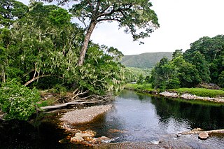
Settlement and forestry station on the Karatara River which flows southwards into Swartvlei. It is situated 5 km west of Barrington and some 40 km northwest of Knysna. It was founded in 1941. The name is of Khoekhoen origin and probably means 'horse hill', after a hillock to the north. Previously the Karatara River was known as the Tsao or Witterivier. [2]

Related Research Articles

Garden Route coastal region in southern South Africa

The Garden Route is a 300-kilometre (190 mi) stretch of the south-eastern coast of South Africa which extends from Mossel Bay in the Western Cape to the Storms River in the Eastern Cape. The name comes from the verdant and ecologically diverse vegetation encountered here and the numerous lagoons and lakes dotted along the coast. It includes towns such as Knysna, Plettenberg Bay, Mossel Bay, Little Brak River and Nature's Valley; with George, the Garden Route's largest city and main administrative centre.

Heidelberg, Western Cape Place in Western Cape, South Africa

Heidelberg is a town in the Western Cape, South Africa. It is located near South Africa's south coast, on the N2 highway, 274 km east of Cape Town. Heidelberg is just east of the Overberg region, and some consider it the beginning of the Garden Route. Heidelberg is part of the Hessequa Local Municipality. Fourie House on Fourie Street is the oldest house in Heidelberg.

Knysna-Amatole montane forests ecoregion in South Africa

The Knysna-Amatole montane forests ecoregion, of the Tropical and subtropical moist broadleaf forests Biome, is in South Africa. It covers an Afromontane area of 3,100 square kilometres (1,200 sq mi) in South Africa's Eastern Cape and Western Cape provinces.

Tsitsikamma National Park A protected area on the Garden Route, Western Cape and Eastern Cape, South Africa

The Tsitsikamma National Park is a protected area on the Garden Route, Western Cape and Eastern Cape, South Africa. It is a coastal reserve well known for its indigenous forests, dramatic coastline, and the Otter Trail. On 6 March 2009 it was amalgamated with the Wilderness National Park and various other areas of land to form the Garden Route National Park.

Wilderness, Western Cape Place in Western Cape, South Africa

Wilderness is a seaside town on the Garden Route of the southern Cape in South Africa.

George Rex was a British-born entrepreneur who spent most of his adult life in the Cape Colony, South Africa. He founded the town of Knysna in the Western Cape and played a key role in its development. Rex filled a number of positions in the Cape Colony – including Marshal of the Vice-admiralty Court, notary public to the Governor and advocate for the Crown – before settling on the farm Melkhoutkraal, in the Knysna district. George Rex was the alleged first son of King George III.

Sedgefield, Western Cape Place in Western Cape, South Africa

Sedgefield is a coastal town on the Garden Route in the Western Cape province of South Africa. It is situated on the N2 national road, between George and Knysna.

Garden Route National Park Coastal national park in the Garden Route region of the Western Cape and Eastern Cape provinces in South Africa

The Garden Route National Park is a national park in the Garden Route region of the Western Cape and Eastern Cape provinces in South Africa. It is a coastal reserve well known for its indigenous forests, dramatic coastline, and the Otter Trail. It was established on 6 March 2009 by amalgamating the existing Tsitsikamma and Wilderness National Parks, the Knysna National Lake Area, and various other areas of state-owned land.

Thomas Charles John Bain South African engineer

Thomas Charles John Bain was a South African road engineer. As a prolific road building pioneer, Bain was responsible for the planning and construction of more than 900 km of roads and mountain passes, many of them still in use today, over a career spanning from 1848 until 1888. These passes through the mountain ranges between the thin coastal plain and the interior of the former Cape Colony in South Africa, played a major role in opening up the vast hinterland of South Africa.

Charles Wilhelm Thesen Norwegian businessman

Charles Wilhelm Thesen was a Norwegian-born South African shipowner and timber merchant who played a leading role in the public affairs of the South African town of Knysna. He was actively involved in the timber and shipbuilding industry of the region, and acquired Paarden Island in the Knysna Lagoon, on which he built a sawmill and shipyard. The island was later renamed Thesen Island, after him and his family.

Rooi-Els, Western Cape Place in Western Cape, South Africa

Rooi-Els is a settlement in Overberg District Municipality in the Western Cape province of South Africa. It was declared a township in June 1948, and is situated 5 km north of Pringle Bay, on the eastern shore of False Bay. It was named after the farm and river by this name.

Brenton-on-Sea Place in Western Cape, South Africa

Brenton-on-Sea is a settlement and seaside resort town 15km west of Knysna in Garden Route District Municipality in the Western Cape province of South Africa.

Buffelsbaai Place in Western Cape, South Africa

Buffelsbaai is a small seaside village 20 kilometres from Knysna in the Garden Route District Municipality in the Western Cape province of South Africa. The village is named after Buffelsbaai which stretches east of the village.

Wittedrif Place in Western Cape, South Africa

Wittedrif is a settlement in Garden Route District Municipality in the Western Cape province of South Africa.

Kariega River river in South Africa

Kariega River is a river located in the Eastern Cape province South Africa. It is an intermittent water course that reaches the ocean through an estuary.

Willowmore Place in Eastern Cape, South Africa

Willowmore is a town in Sarah Baartman District Municipality in the Eastern Cape province of South Africa.

Millwood, South Africa

Millwood in South Africa was the site of a short-lived gold rush in the 1880s. Millwood Mining Village was located in the foothills of the Outeniqua Mountains near Knysna and had a population of a few hundred at the height of its small-scale mining activity which lasted only five years, largely due to the difficulty of following the vein in much-folded formations.

De Vlugt Place in Western Cape, South Africa

De Vlugt is a town in George Local Municipality in the Western Cape province of South Africa.

References

  1. 1 2 3 4 "Main Place Karatara". Census 2011.
  2. Raper, Peter E. (1987). Dictionary of Southern African Place Names. Internet Archive. p. 241. Retrieved 28 August 2013.