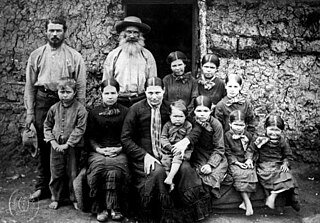
Boers are the descendants of the proto Afrikaans-speaking Free Burghers of the eastern Cape frontier in Southern Africa during the 17th, 18th, and 19th centuries. From 1652 to 1795, the Dutch East India Company controlled Dutch Cape Colony, but the United Kingdom incorporated it into the British Empire in 1806. The name of the group is derived from Trekboer then later "boer", which means "farmer" in Dutch and Afrikaans.

Afrikaner Calvinism is a cultural and religious development among Afrikaners that combined elements of seventeenth-century Calvinist doctrine with a "chosen people" ideology based in the Bible. It had origins in ideas espoused in the Old Testament of the Jews as the chosen people.

Daniël François Malan was a South African politician who served as the fourth prime minister of South Africa from 1948 to 1954. The National Party implemented the system of apartheid, which enforced racial segregation laws, during his tenure as prime minister.
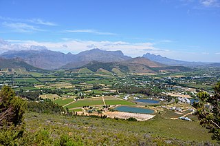
Franschhoek is a small town in the Western Cape Province and one of the oldest towns in South Africa. It was formerly known as Oliphants hoek. It is situated about 75 kilometres (47 mi) from Cape Town, a 45-minute drive away. The whole area, including townships such as Groendal and suburbs such as Wemmershoek, has a population of slightly over 20,000 people while the town proper, known as Hugenote, has a population of around 1,000. Since 2000, it has been incorporated into Stellenbosch Municipality. In 2022, Franschhoek was mentioned in Time magazine as one of the top 50 places in the world to visit.

Bethulie is a small sheep and cattle farming town in the Free State province of South Africa. The name meaning chosen by God was given by directors of a mission station in 1829 which the town formed around. The mission building is the oldest settler built building still standing in the Free State. The town was also home to one of the largest concentration camps run by the British during the Boer War. The Dutch Reformed Church was built in 1862.

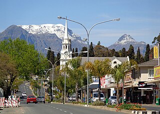
Worcester is a town in the Western Cape, South Africa. It is the third-largest city in the Western Cape Province of South Africa. It is located 120 kilometres (75 mi) north-east of Cape Town on the N1 highway north to Johannesburg.

Heidelberg is a town in the Western Cape, South Africa. It is located near South Africa's south coast, on the N2 highway, within the Hessequa region, 274 km east of Cape Town. Heidelberg marks the start of the Garden Route. Heidelberg is part of the Hessequa Local Municipality.
The Dutch Reformed Church is a Reformed Christian denomination in South Africa. It also has a presence in neighbouring countries, such as Namibia, Eswatini, and parts of Botswana, Zimbabwe and Zambia. In 2013 it claimed 1.1 million members and 1,602 ordained ministers in 1,158 congregations.
Wellington is a town in the Western Cape Winelands, a 45-minute drive from Cape Town, in South Africa with a population of approximately 62,000. Wellington's economy is centered on agriculture such as wine, table grapes, deciduous fruit, and a brandy industry. The town is located 75 km north-east of Cape Town, reached by the N1 motorway and R44. Due to the growth of the Vlakkeland and Mbekweni township south of the town, it now forms a de facto urban unit with Paarl, just 10 km to the south. Wellington now officially falls under the Drakenstein Local Municipality, which also covers Saron and Paarl.
The Uniting Reformed Church in Southern Africa was formed by the union of the black and coloured Nederduits Gereformeerde Kerk mission churches.

Carl Hugo Hahn (1818–1895) was a Baltic German missionary and linguist who worked in South Africa and South-West Africa for most of his life. Together with Franz Heinrich Kleinschmidt, he set up the first Rhenish mission station to the Herero people in Gross Barmen. Hahn is known for his scientific work on the Herero language.
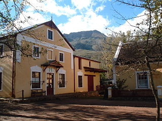
Genadendal is a town in the Western Cape province of South Africa, built on the site of the oldest mission station in the country. It was originally known as Baviaanskloof, but was renamed Genadendal in 1806. Genadendal was the place of the first Teachers' Training College in South Africa, founded in 1838.

Warmbad is a settlement located in the ǁKaras Region of southern Namibia. It is situated south of Karasburg at the Homs River, close to the border with South Africa, and belongs to the Karasburg electoral constituency.

Colesberg is a town with 17,354 inhabitants in the Northern Cape province of South Africa, located on the main N1 road from Cape Town to Johannesburg.

Carnarvon is a small town in the Northern Cape Province of South Africa.
Hermann Heinrich Vedder was a German missionary, linguist, ethnologist and historian. Originally a silk weaver, he received missionary training by the Rhenish Missionary Society in Barmen between 1894 and 1903, whereafter he was sent to German South West Africa in 1905 and worked as a missionary and teacher trainer until his retirement, first for the black workers and prisoners-of-war in Swakopmund, then at the small mission station Gaub in the Otavi Mountains, and from 1922 onwards in Okahandja, where he taught at the Augustineum school.

Leonardville is a village in eastern Namibia, situated on the Nossob River in the south-western corner of the Omaheke Region. It belongs to the Aminuis electoral constituency.

Steinkopf is a town in Namakwa District Municipality in the Northern Cape province of South Africa.

Christianity is the dominant religion in South Africa, with almost 80% of the population in 2001 professing to be Christian. No single denomination predominates, with mainstream Protestant churches, Pentecostal churches, African initiated churches, and the Catholic Church all having significant numbers of adherents. Importantly, there is significant and sustained syncretism with African Traditional Religion among most self-professed Christians in South Africa.

The South African Sendinggestig Museum was established in 1977 and is currently situated in the centre of Cape Town, Western Cape, South Africa. It is a province-aided museum which receives support from the Government of the Western Cape Province.


