
Plettenberg Bay, nicknamed Plett, is the primary town of the Bitou Local Municipality in the Western Cape Province of South Africa. According to the census of 2001, the town had a population of 29,149. It was originally named Bahia Formosa by early Portuguese explorers and lies on South Africa's Garden Route 210 km from Port Elizabeth and about 600 km from Cape Town.

Knysna is a town with 76,150 inhabitants in the Western Cape province of South Africa. It is one of the destinations on the loosely defined Garden Route tourist route. It is situated 60 kilometres east of the city of George on the N2 highway, and 33 kilometres west of the Plettenberg Bay on the same road.

Knysna Municipality is a local municipality within the Garden Route District Municipality, in the Western Cape province of South Africa. As of 2011, the population is 68,659. Its municipal code is WC048.
Bitou Municipality, formerly known as Plettenberg Bay Municipality, is a local municipality within the Garden Route District Municipality, in the Western Cape province of South Africa. Its municipality code is WC047.

Swellendam is the third oldest town in South Africa, a town with 17,537 inhabitants situated in the Western Cape province. The town has over 50 provincial heritage sites, most of them buildings of Cape Dutch architecture. Swellendam is situated on the N2, approximately 220 km from both Cape Town and George.

George is the second largest city in the Western Cape province of South Africa. The city is a popular holiday and conference centre, as well as the administrative and commercial hub and the seat of the Garden Route District Municipality. It is named after the British Monarch George III.

Heidelberg is a town in the Western Cape, South Africa. It is located near South Africa's south coast, on the N2 highway, within the Hessequa region, 274 km east of Cape Town. Heidelberg marks the start of the Garden Route. Heidelberg is part of the Hessequa Local Municipality.
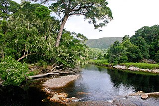
The Knysna–Amatole montane forests ecoregion, of the tropical and subtropical moist broadleaf forests biome, is in South Africa. It covers an Afromontane area of 3,100 square kilometres (1,200 sq mi) in the Eastern Cape and Western Cape provinces.

The Tsitsikamma National Park is a protected area on the Garden Route, Western Cape and Eastern Cape, South Africa. It is a coastal reserve well known for its indigenous forests, dramatic coastline, and the Otter Trail. On 6 March 2009 it was amalgamated with the Wilderness National Park and various other areas of land to form the Garden Route National Park.

Kfm 94.5 is an adult contemporary radio station based in Cape Town, South Africa
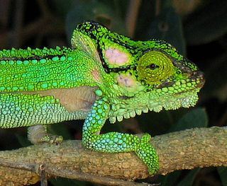
The Knysna dwarf chameleon is a species of dwarf chameleon in the Bradypodion genus that is endemic to South Africa. It is a forest dweller, found only in a limited range in the afromontane forests near Knysna, South Africa, and in certain surrounding areas.

Rooiels is a settlement in Overberg District Municipality in the Western Cape province of South Africa. It was declared a township in June 1948, and is situated 5 km north of Pringle Bay, on the eastern shore of False Bay. It was named after the farm and river of the same name, which were named after the red alder tree known as rooiels in Afrikaans.

Buffelsbaai is a small seaside village 20 kilometres from Knysna in the Garden Route District Municipality in the Western Cape province of South Africa. The village is named after Buffelsbaai which stretches east of the village. It is a popular vacation destination with a small waterfront with stores.

Willowmore is a town in Sarah Baartman District Municipality in the Eastern Cape province of South Africa.

An unusually large south Atlantic storm struck the southern coast of South Africa on 7 June 2017 with wind speeds as high as 120 km/h. Wave heights of 9–12 metres were recorded between Cape Columbine and Cape Agulhas. The storm directly caused eight deaths and damaged 135 schools across the Western Cape. Around 800 homes were flooded across the city of Cape Town due to the storm.
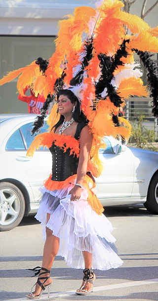
The Pink Loerie Mardi Gras and Arts Festival is an annual LGBTQ Pride carnival event and parade held in Knysna, a coastal township in the Western Cape province of South Africa. Events include their version of the Wigstock drag queen festival, a bear fest, athletic events, and an art festival. It is one of the country's largest LGBTQ events. Since its start in 2000 it has grown to be a significant event for the town culminating in the grand finale of Pink Loerie, Knysna Pride parade and its 1000-person after-party held on the final weekend with floats, performers, and DJs. The Knysna loerie is a green bird but the color pink has a long association with LGBTQ culture.
Eleanore Rochelle Jacquelene Spies is a South African politician who has been a Member of Parliament for the Democratic Alliance since 2019.

Farleigh is a small town in the Western Cape province of South Africa. The settlement is also a forestry station. Farleigh is 3 km northeast of Karatara and 8 km northwest of Rheenendal, with the closest major town being Knysna. The town is about 511 metres above sea level.
Gouna is a village in the Western Cape in South Africa. The village lies about 6 km north of Knysna, 11 km east of Rheenendal and about 12 km northwest of Bracken Hill. Located in the Knysna forests, the village lies on a hill that forms part of the Outeniqua Mountains.

Jonkersberg is a small village and forestry station in the Western Cape province of South Africa.


