
Breede Valley Municipality is a local municipality located within the Cape Winelands District Municipality, in the Western Cape province of South Africa. As of 2007, it had a population of 166,825. Its municipality code is WC025.

Wilderness is a seaside town on the Garden Route of the southern Cape in South Africa. It is situated a short distance to the east from the city of George, on the N2 down the Kaaiman's River Pass.

The Garden Route National Park is a national park in the Garden Route region of the Western Cape and Eastern Cape provinces in South Africa. It is a coastal reserve well known for its indigenous forests, dramatic coastline, and the Otter Trail. It was established on 6 March 2009 by amalgamating the existing Tsitsikamma and Wilderness National Parks, the Knysna National Lake Area, and various other areas of state-owned land.
Wilderness National Park, also called the Wilderness Section, is located around the seaside town of Wilderness between the larger towns of George and Knysna, in the Western Cape. It is a protected area of South Africa forming part of the Garden Route National Park.
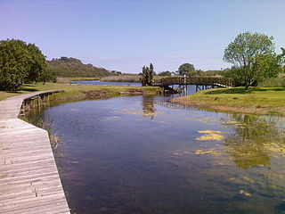
The Touws River is a river in the Western Cape province of South Africa. It is a tributary of the Groot River, part of the Gourits River basin. A notable resident of the town is Margaret Maritz who, as of 2022, aged 116, was regarded as one of the oldest people in South Africa.

De Doorns is situated in the Breede Valley Local Municipality, Cape Winelands District Municipality in the Western Cape province of South Africa.

Touws River is a small railway town of 8,126 people in the Western Cape province of South Africa. It is located on the river of the same name, about 160 kilometres (100 mi) north-east of Cape Town. The Touwsrivier CPV Solar Project is located just outside of the town and supplies 50 MW to the national electrical grid.
Touws River may refer to:

The South African Railways Class 4E of 1952 was an electric locomotive.

The South African Railways Class 5E, Series 2 of 1957 was an electric locomotive.

The South African Railways Class 16D 4-6-2 of 1925 was a steam locomotive.

The South African Railways Class 8Z 2-8-0 of 1904 was a steam locomotive from the pre-Union era in the Cape of Good Hope.

The South African Railways Class 7E 4-8-0 of 1899 was a steam locomotive from the pre-Union era in the Cape of Good Hope.
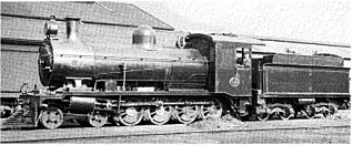
The South African Railways Class 7F 4-8-0 of 1913 was a steam locomotive.

The South African Railways Class MC1 2-6-6-0 of 1914 was a steam locomotive.

The South African Railways Class GG 2-6-2+2-6-2 of 1925 was an articulated steam locomotive.

The Groot River is a river in the southern area of the Western Cape province of South Africa. It is a right hand tributary of the Gourits River.
Air Defence Artillery School is an artillery unit of the South African Army. It is located on the southern side of Kimberley near the airport in an area known as Diskobolos clustered with other military units.
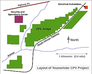
Touwsrivier CPV Solar Project is a 44 MWp (36 MWAC) concentrator photovoltaics (CPV) power station located 13 km outside the town of Touwsrivier in the Western Cape of South Africa. The installation reached full capacity in December 2014 and is the second largest operating CPV facility in the world. Electricity produced by the plant is fed into the national grid operated by Eskom under a 20-year power purchase agreement (PPA).

Woodville is a small hamlet in the Western Cape, South Africa. The settlement is located about 15 km west of Karatara and about 17 km east of George, with the closest town being Touwsranten located 5 km east. Woodville lies at the foot of the Outeniqua Mountains and is about 2 km east of the Woodville Big Tree, the third largest in South Africa.


