
Royalston is a town in Worcester County, Massachusetts, United States. The population was 1,250 at the 2020 census.

Ruidoso is a village in Lincoln County, New Mexico, United States, adjacent to the Lincoln National Forest. The population was 7,679 at the 2020 census. The city of Ruidoso Downs and the unincorporated area of Alto are suburbs of Ruidoso, and contribute to the Ruidoso Micropolitan Statistical Area's population of 21,223.

Everett is a borough in Bedford County, Pennsylvania, United States. The population was 1,765 at the 2020 census.

Templeogue is a southwestern suburb of Dublin in Ireland. It lies between the River Poddle and River Dodder, and is about halfway from Dublin's centre to the mountains to the south.

Rondebosch is one of the Southern Suburbs of Cape Town, South Africa. It is primarily a residential suburb, with shopping and business districts as well as the main campus of the University of Cape Town.
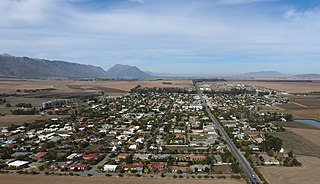
Reitz is a small maize, wheat and cattle farming town located in the east of the Free State province of South Africa.

Komatipoort is a town situated at the confluence of the Crocodile and Komati Rivers in Mpumalanga province, South Africa. The town is 8 km from the Crocodile Bridge Gate into the Kruger National Park, just 5 km from the Mozambique border and 65 km from the Eswatini border.

Bítovany is a municipality and village in Chrudim District in the Pardubice Region of the Czech Republic. It has about 400 inhabitants.

Loučovice is a municipality and village in Český Krumlov District in the South Bohemian Region of the Czech Republic. It has about 1,500 inhabitants.

Nasavrky is a town in Chrudim District in the Pardubice Region of the Czech Republic. It has about 1,700 inhabitants.
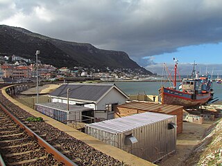
Kalk Bay is a fishing village and suburb of Cape Town. It lies on the east coast of False Bay. Much of the town is built on the slopes of mountains which border the sea, with peaks of Table Mountain Sandstone forming valleys. The railway from Cape Town to Simon's Town passes through Kalk Bay, which has one station near the harbour.

Helderberg refers to a planning district of the City of Cape Town metropolitan municipality, the mountain after which it is named, a wine-producing area in the Western Cape province of South Africa, or a small census area in Somerset West.

De Rust is a small village at the gateway to the Klein Karoo, South Africa. The name is Dutch and literally translates to "The Rest", referring to the town's original purpose of being a resting place for settlers en route through the challenging terrain of a nearby Swartberg gorge.

Horní Bečva is a municipality and village in Vsetín District in the Zlín Region of the Czech Republic. It has about 2,400 inhabitants.

Strážný is a market town in Prachatice District in the South Bohemian Region of the Czech Republic. It has about 400 inhabitants.
Sir Lowry's Pass Village is a town near the base of Sir Lowry's Pass, about 60 km from Cape Town, South Africa.
Porterville is a town in the Western Cape province of South Africa.

Mladé Buky is a market town in Trutnov District in the Hradec Králové Region of the Czech Republic. It has about 2,300 inhabitants.

Halenkov is a municipality and village in Vsetín District in the Zlín Region of the Czech Republic. It has about 2,400 inhabitants.
Gouna is a village in the Western Cape in South Africa. The village lies about 6 km north of Knysna, 11 km east of Rheenendal and about 12 km northwest of Bracken Hill. Located in the Knysna forests, the village lies on a hill that forms part of the Outeniqua Mountains.


