
Cape Town is the legislative capital of South Africa. It is the country's oldest city and the seat of the Parliament of South Africa. It is the country's second-largest city, after Johannesburg, and the largest in the Western Cape. The city is part of the City of Cape Town metropolitan municipality.

The Democratic Republic of the Congo (DRC) is the largest country of sub-Saharan Africa, occupying some 2,344,858 square kilometres (905,355 sq mi). Most of the country lies within the vast hollow of the Congo River basin. The vast, low-lying central area is a plateau-shaped basin sloping toward the west, covered by tropical rainforest and criss-crossed by rivers. The forest center is surrounded by mountainous terraces in the west, plateaus merging into savannas in the south and southwest. Dense grasslands extend beyond the Congo River in the north. High mountains of the Ruwenzori Range are found on the eastern borders with Rwanda and Uganda.
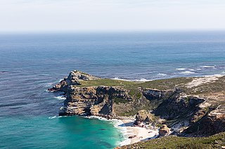
The Cape of Good Hope is a rocky headland on the Atlantic coast of the Cape Peninsula in South Africa.

South Africa occupies the southern tip of Africa, its coastline stretching more than 2,850 kilometres from the desert border with Namibia on the Atlantic (western) coast southwards around the tip of Africa and then northeast to the border with Mozambique on the Indian (eastern) coast. The low-lying coastal zone is narrow for much of that distance, soon giving way to a mountainous escarpment that separates the coast from the high inland plateau. In some places, notably the province of KwaZulu-Natal in the east, a greater distance separates the coast from the escarpment. Although much of the country is classified as semi-arid, it has considerable variation in climate as well as topography. The total land area is 1,220,813 km2 (471,359 sq mi). It has the 23rd largest Exclusive Economic Zone of 1,535,538 km2 (592,875 sq mi).

Benin, a narrow, key-shaped, north–south strip of land in West Africa, lies between the Equator and the Tropic of Cancer. Its latitude ranges from 6°30′ N to 12°30′ N and its longitude from 1° E to 3°40′ E. It is bounded by Togo to the west, Burkina Faso and Niger to the north, Nigeria to the east, and the Bight of Benin to the south.

Durban is the third-most populous city in South Africa, after Johannesburg and Cape Town, and the largest city in the province of KwaZulu-Natal. Situated on the east coast of South Africa, on the Natal Bay of the Indian Ocean, Durban is South Africa's busiest port and was formerly named Port Natal. North of the harbour and city centre lies the mouth of the Umgeni River; the flat city centre rises to the hills of the Berea on the west; and to the south, running along the coast, is the Bluff. Durban is the seat of the larger eThekwini Metropolitan Municipality, which spans an area of 2,556 km2 (987 sq mi) and had a population of 4.2 million in 2022, making the metropolitan population one of Africa's largest on the Indian Ocean. Within the city limits, Durban's population was 595,061 in 2011. The city has a humid subtropical climate, with hot, wet summers and mild, dry winters.

Stellenbosch is a town in the Western Cape province of South Africa, situated about 50 kilometres east of Cape Town, along the banks of the Eerste River at the foot of the Stellenbosch Mountain. The town became known as the City of Oaks or Eikestad in Afrikaans and Dutch due to the large number of oak trees that were planted by its founder, Simon van der Stel, to grace the streets and homesteads.

Midrand is a town in central Gauteng, South Africa. It is situated in-between Centurion and Sandton. Formerly an independent municipality, Midrand now forms part of the City of Johannesburg Metropolitan Municipality.

Bansko is a town in southwestern Bulgaria, located in Blagoevgrad Oblast near the city of Razlog. Once mainly a stockbreeding and travelling merchant community, the town is now an international centre for winter and summer tourism. More recently Bansko has become a known hotspot for digital nomads driven in part by the relative affordability of the location combined with its natural scenery.

Margate is a coastal resort town in the KwaZulu-Natal province, about 20 kilometres south-west of Port Shepstone and 127 kilometres south-west of Durban. The river which flows into the sea at Margate is called "Nkhongweni" (place of entreaty) as the original inhabitants of the area were reputed to be so mean resulting in travellers begging for hospitality.

Břeclav is a town in the South Moravian Region of the Czech Republic. It has about 25,000 inhabitants.

Bronkhorstspruit is a town 50 km east of Pretoria, Gauteng, South Africa along the N4 highway towards eMalahleni. It also includes three townships called Zithobeni, Rethabiseng and Ekangala. On 18 May 2011, the Tshwane Metropolitan Municipality took over the municipal administration from the abolished Kungwini Local Municipality, which makes Bronkhorstspruit part of Tshwane.
Reitz is a small maize, wheat and cattle farming town located in the east of the Free State province of South Africa.

Zeerust is a commercial town situated in the Ngaka Modiri Molema district of North West Province, South Africa. It lies in the Marico valley, approximately 240 kilometres northwest of Johannesburg. It lies on the N4, the main road link between South Africa and Botswana. There are large cattle ranches in the area, as well as wheat, maize, tobacco and citrus fruit farms. There are also fluorite and chromite mines in the vicinity. Tourism is also a developing industry.

Heidelberg is a town in the Western Cape, South Africa. It is located near South Africa's south coast, on the N2 highway, within the Hessequa region, 274 km east of Cape Town. Heidelberg marks the start of the Garden Route. Heidelberg is part of the Hessequa Local Municipality.
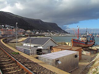
Kalk Bay is a fishing village and suburb of Cape Town. It lies on the east coast of False Bay. Much of the town is built on the slopes of mountains which border the sea, with peaks of Table Mountain Sandstone forming valleys. The railway from Cape Town to Simon's Town passes through Kalk Bay, which has one station near the harbour.
Eerste River is a town in the Western Cape, South Africa and a suburb of the City of Cape Town. It forms part of the Eastern Suburbs zone of the city situated behind the Stellenbosch/Vlaeberg Hills on the eastern outskirts of the city..

Nové Veselí is a market town in Žďár nad Sázavou District in the Vysočina Region of the Czech Republic. It has about 1,400 inhabitants.

Port St. Johns is a town of about 6,500 people on the Wild Coast in the Eastern Cape province of South Africa. It is situated at the mouth of the Umzimvubu River, 220 kilometres (140 mi) northeast of East London and 70 kilometres (40 mi) east of Mthatha. Port St. Johns was the birthplace of Capital Radio 604.
Gouna is a village in the Western Cape in South Africa. The village lies about 6 km north of Knysna, 11 km east of Rheenendal and about 12 km northwest of Bracken Hill. Located in the Knysna forests, the village lies on a hill that forms part of the Outeniqua Mountains.


