
Arkansas is a landlocked state in the West South Central region of the Southern United States. It borders Missouri to the north, Tennessee and Mississippi to the east, Louisiana to the south, Texas to the southwest, and Oklahoma to the west. Its name derives from the Osage language, and refers to their relatives, the Quapaw people. The state's diverse geography ranges from the mountainous regions of the Ozark and Ouachita Mountains, which make up the U.S. Interior Highlands, to the densely forested land in the south known as the Arkansas Timberlands, to the eastern lowlands along the Mississippi River and the Arkansas Delta.

Powhatan County is a county located in the Commonwealth of Virginia. As of the 2020 census, the population was 30,033. Its county seat is Powhatan.
St. John the Baptist Parish is a parish located in the U.S. state of Louisiana. At the 2020 census, the population was 42,477. The parish seat is Edgard, an unincorporated area, and the largest city is LaPlace, which is also unincorporated.

The Mormon Trail is the 1,300-mile (2,100 km) long route from Illinois to Utah on which Mormon pioneers traveled from 1846–47. Today, the Mormon Trail is a part of the United States National Trails System, known as the Mormon Pioneer National Historic Trail.

The Wind River Range is a mountain range of the Rocky Mountains in western Wyoming in the United States. The range runs roughly NW–SE for approximately 100 mi (160 km). The Continental Divide follows the crest of the range and includes Gannett Peak, which at 13,802 ft (4,207 m), is the highest peak in Wyoming; and also Fremont Peak at 13,750 ft (4,191 m), the third highest peak in Wyoming. There are more than 40 other named peaks in excess of 12,999 ft (3,962 m). With the exception of the Grand Teton in the Teton Range, the next 19 highest peaks in Wyoming after Gannett are also in the Winds.

The Cederberg mountains are located near Clanwilliam, approximately 300 km north of Cape Town, South Africa at about 32°30′S19°0′E. The mountain range is named after the endangered Clanwilliam cedar, which is a tree endemic to the area. The mountains are noted for dramatic rock formations and San rock art. The Cederberg Wilderness Area is administered by CapeNature.

Blair Atholl is a village in Perthshire, Scotland, built about the confluence of the Rivers Tilt and Garry in one of the few areas of flat land in the midst of the Grampian Mountains. The Gaelic place-name Blair, from blàr, 'field, plain', refers to this location. Atholl, which means 'new Ireland', from the archaic Ath Fhodla is the name of the surrounding district.

The San Bernardino Mountains are a high and rugged mountain range in Southern California in the United States. Situated north and northeast of San Bernardino and spanning two California counties, the range tops out at 11,503 feet (3,506 m) at San Gorgonio Mountain – the tallest peak in Southern California. The San Bernardinos form a significant region of wilderness and are popular for hiking and skiing.

Lake Clark National Park and Preserve is a United States national park and preserve in southwest Alaska, about 100 miles (160 km) southwest of Anchorage. The park was first proclaimed a national monument in 1978, then established as a national park and preserve in 1980 by the Alaska National Interest Lands Conservation Act. The park includes many streams and lakes vital to the Bristol Bay salmon fishery, including its namesake Lake Clark. A wide variety of recreational activities may be pursued in the park and preserve year-round. The park protects rainforests along the coastline of Cook Inlet, alpine tundra, glaciers, glacial lakes, major salmon-bearing rivers, and two volcanoes, Mount Redoubt and Mount Iliamna. Mount Redoubt is active, erupting in 1989 and 2009. The wide variety of ecosystems in the park mean that virtually all major Alaskan animals, terrestrial and marine, may be seen in and around the park. Salmon, particularly sockeye salmon, play a major role in the ecosystem and the local economy. Large populations of brown bears are attracted to feed on the spawning salmon in the Kijik River and at Silver Salmon Creek. Bear watching is a common activity in the park.

Corfe Mullen is a village in Dorset, England, on the north-western urban fringe of the South East Dorset conurbation. The community had a population of 10,133 at the 2011 Census. It is served by six churches, four pubs, five schools, a library, various shops and local businesses, a village hall, and many community and sports organisations. On 10 December 2019 The Corfe Mullen Parish Council resolved to adopt Town Council status, citing potential financial benefits. In all other aspects Corfe Mullen is still very much a village, albeit a large one.

The Angeles National Forest (ANF) of the United States Forest Service is located in the San Gabriel Mountains and Sierra Pelona Mountains, primarily within Los Angeles County in southern California. The ANF manages a majority of the San Gabriel Mountains National Monument.

The River Esk, sometimes called the Cumbrian Esk, is a river in Cumbria, England. It flows for approximately 25 km from its source in the Scafells range of mountains to its estuary at Ravenglass. The valley it flows through is known as Eskdale. It is one of two Rivers Esk in Cumbria, and not to be confused with the Border Esk which flows into Cumbria from Scotland.
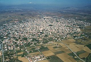
Ptolemaida is a town and a former municipality in Kozani regional unit, Western Macedonia, Greece. Since the 2011 local government reform it is part of the municipality Eordaia, of which it is the seat and a municipal unit. It is known for its coal (lignite) mines and its power stations.

George Municipality is a local municipality within the Garden Route District Municipality, in the Western Cape province of South Africa. As of 2011, the population is 193,672. Its municipality code is WC044.

Zgharta, also spelled Zghorta, is a city in North Lebanon, with an estimated population of around 50,000. It is the second biggest city in Northern Lebanon after Tripoli. Zgharta is officially the Zgharta-Ehden municipality.

George is the second largest city in the Western Cape province of South Africa. The city is a popular holiday and conference centre, as well as the administrative and commercial hub and the seat of the Garden Route District Municipality. It is named after the British Monarch George III.

Camlough is a village west of Newry in County Armagh, Northern Ireland. The village is named after a lake, known as the Cam Lough. South of the village is Camlough Mountain, part of the Ring of Gullion and is designated an Area of Outstanding Natural Beauty. Camlough had a population of 1,074 at the 2011 Census.

Carson National Forest is a national forest in northern New Mexico, United States. It encompasses 6,070 square kilometers and is administered by the United States Forest Service. The Forest Service's "mixed use" policy allows for its use for recreation, grazing, and resource extraction.

The Great Indian Warpath (GIW)—also known as the Great Indian War and Trading Path, or the Seneca Trail—was that part of the network of trails in eastern North America developed and used by Native Americans which ran through the Great Appalachian Valley. The system of footpaths extended from what is now upper New York to deep within Alabama. Various Native peoples traded and made war along the trails, including the Catawba, numerous Algonquian tribes, the Cherokee, and the Iroquois Confederacy. The British traders' name for the route was derived from combining its name among the northeastern Algonquian tribes, Mishimayagat or "Great Trail", with that of the Shawnee and Delaware, Athawominee or "Path where they go armed".
Belize, on the east coast of Central America, southeast of Mexico, was inhabited by the indigenous peoples who fought off the Spaniards in an attempt to preserve their heritage and to avoid the fate of their neighbors who were conquered and under Spanish rule. While this was going on, British pirates would rob Spanish merchant ships and navigate through the shallow waters and small islands even going up river later to hide their bounty. The indigenous people of Belize did not resist the British like they did the Spanish. In the 17th century, however, the British settlement became a formal British crown colony from 1862 through 1964, where they first achieved self government and later in 1981 became an independent country recognized globally with all its territory intact. The British brought along with them slaves taken from Congo and Angola during the eighteenth century.


