Avontuur | |
---|---|
Avontuur's narrow gauge railway station | |
Coordinates: 33°43′30″S23°10′08″E / 33.725°S 23.169°E Coordinates: 33°43′30″S23°10′08″E / 33.725°S 23.169°E | |
Country | South Africa |
Province | Western Cape |
District | Garden Route |
Municipality | George |
Population | |
• Total | 238 |
Time zone | UTC+2 (SAST) |
PO box | 6490 |
Area code | 044 |
Avontuur is a town situated in the Garden Route District Municipality in the Western Cape province of South Africa. [2] The town is located 13km south-east of Uniondale on an intersection of the R339 and R62 regional routes.
The Garden Route District Municipality is a district municipality located in the Western Cape Province of South Africa. Its municipality code is DC4.
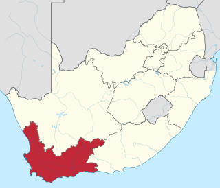
The Western Cape is a province of South Africa, situated on the south-western coast of the country. It is the fourth largest of the nine provinces with an area of 129,449 square kilometres (49,981 sq mi), and the third most populous, with an estimated 6.6 million inhabitants in 2018. About two-thirds of these inhabitants live in the metropolitan area of Cape Town, which is also the provincial capital. The Western Cape was created in 1994 from part of the former Cape Province.
South Africa, officially the Republic of South Africa (RSA), is the southernmost country in Africa. It is bounded to the south by 2,798 kilometres (1,739 mi) of coastline of Southern Africa stretching along the South Atlantic and Indian Oceans; to the north by the neighbouring countries of Namibia, Botswana, and Zimbabwe; and to the east and northeast by Mozambique and Eswatini (Swaziland); and it surrounds the enclaved country of Lesotho. South Africa is the largest country in Southern Africa and the 25th-largest country in the world by land area and, with over 57 million people, is the world's 24th-most populous nation. It is the southernmost country on the mainland of the Old World or the Eastern Hemisphere. About 80 percent of South Africans are of Bantu ancestry, divided among a variety of ethnic groups speaking different African languages, nine of which have official status. The remaining population consists of Africa's largest communities of European, Asian (Indian), and multiracial (Coloured) ancestry.
The name is Afrikaans for adventure; its origin, however, remains uncertain. The river from which the town takes its name was known in 1778. [3]
The following lists events that happened during 1903 in South Africa.
The R339 is a Regional Route in South Africa that connects Knysna with Uniondale via Avontuur. It is primarily a gravel road and crosses the Langkloof Mountains at Prince Alfred's pass.
Port Elizabeth or The Bay is one of the major cities in South Africa; it is situated in the Eastern Cape Province, 770 km (478 mi) east of Cape Town. The city, often shortened to PE and nicknamed "The Windy City", stretches for 16 kilometres (10 mi) along Algoa Bay, and is one of the major seaports in South Africa. Port Elizabeth is the southernmost large city on the African continent, just farther south than Cape Town. Port Elizabeth was founded as a town in 1820 to house British settlers as a way of strengthening the border region between the Cape Colony and the Xhosa. It now forms part of the Nelson Mandela Bay Metropolitan Municipality, which has a population of over 1.3 million.
The South African Railways Class NG G13 2-6-2+2-6-2 of 1927 was a narrow gauge articulated steam locomotive.
The South African Railways Class NG15 2-8-2 of 1931 was a narrow-gauge steam locomotive.
The Langkloof is a 160 km long valley in South Africa, lying between Herold, a small village northeast of George, and The Heights - just beyond Twee Riviere.
The R62 is a provincial route in South Africa that connects Ashton with Humansdorp. The R62 runs through the Little Karoo and the Langkloof, passing through Montagu, Ladismith, Calitzdorp, Oudtshoorn, and Joubertina.
The Avontuur Railway is a closed railway line between Port Elizabeth and the town of Avontuur in the Western and Eastern Cape provinces of South Africa. It is the longest 2 ft narrow gauge route in the world at a length of 285 kilometres (177 mi). "Avontuur" is the Afrikaans and Dutch word for "adventure".
Joubertina is a small town in the Kou-Kamma Local Municipality, Sarah Baartman District of the Eastern Cape province of South Africa.
Haarlem is a settlement in Garden Route District Municipality in the Western Cape province of South Africa.
The South African Railways Class NG G11 2-6-0+0-6-2 of 1919 was a narrow gauge steam locomotive.
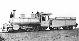
The South African Railways Class NG8 4-6-0 of 1904 was a narrow-gauge steam locomotive from the pre-Union era in the Cape of Good Hope.
The South African Railways Class NG9 4-6-0 of 1915 was a narrow-gauge steam locomotive.
The South African Railways Class NG10 4-6-2 of 1916 was a narrow-gauge steam locomotive.
Loerie is a town in Sarah Baartman District Municipality in the Eastern Cape province of South Africa.
Krakeel River is a town in Sarah Baartman District Municipality in the Eastern Cape province of South Africa.
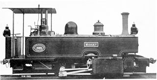
The Cape Government Railways Type C 0-4-0T Midget of 1902 was a South African steam locomotive from the pre-Union era in the Cape of Good Hope.
The Cape Government Railways NG 0-6-0T of 1903 was a South African steam locomotive from the pre-Union era in the Cape of Good Hope.
The Cape Government Railways Type A 2-6-4T of 1902 was a South African steam locomotive from the pre-Union era in the Cape of Good Hope.
The Cape Government Railways NG 0-4-0T was a South African steam locomotive from the pre-Union era in the Cape of Good Hope.