Stilbaai

Last updated

Stilbaai
Stilbaai (Western Cape), looking east.JPG
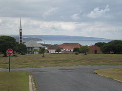
Stilbaai, with the Dutch Reformed Church in Stilbaai West, looking east
South Africa Western Cape location map.svg
Red pog.svg
Stilbaai
South Africa adm location map.svg
Red pog.svg
Stilbaai
Africa location map.svg
Red pog.svg
Stilbaai
Coordinates: 34°22′06″S21°24′40″E / 34.36833°S 21.41111°E / -34.36833; 21.41111
Country South Africa
Province Western Cape
District Garden Route
Municipality Hessequa
Area
[1]
  Total25.48 km2 (9.84 sq mi)
Highest elevation
18 m (59 ft)
Lowest elevation
0 m (0 ft)
Population
 (2011) [1]
  Total3,514
  Density140/km2 (360/sq mi)
Racial makeup (2011)
[1]
   Black African 3.5%
   Coloured 3.2%
   Indian/Asian 0.1%
   White 92.3%
  Other0.8%
First languages (2011)
[1]
   Afrikaans 84.5%
   English 13.7%
  Other1.8%
Time zone UTC+2 (SAST)
Postal code (street)
6674
PO box
6674
Area code 028

Stilbaai, also known as the Bay of Sleeping Beauty, is a town along the southern coast of South Africa about four hours by car from Cape Town. It is part of the Hessequa Local Municipality in the Western Cape province.

Contents

The town is one of the most visited coastal destinations within South Africa, and home to many travellers experiences. The Goukou River and warm Indian Ocean are some of the most prominent natural features. As part of the Cape Floral Kingdom, the town also holds great Fynbos diversity.

History

Stilbaai is host to a number of interesting archaeological sites, including ancient fish traps thought to have been built by early ancestors of the Khoi people of the Southern Cape, and a shell landfill that has been carbon dated to around 1000 BC.

Another archaeological site is situated in a group of caves at Blombos cave, about 12 kilometres from Stilbaai. Artifacts found at Blombos have been carbon dated to around 77,000 BP, making it the oldest known human settlement today.

Geography

Climate

Stilbaai has a temperate climate and receives almost the same amount of rainfall in all four seasons, with peaks in autumn and spring. Temperature averages between 20 and 28 °C in the summer and between 12 and 20 °C in the winter. Rainfall is 639.2 mm per annum on average. [2]

Parks and greenspace

Stilbaai owns a large selection of nature reserves. To the east is Pauline Bohnen Nature Reserve, a large reserve with various hiking routes. The Skulpiesbaai Nature Reserve is situated near the harbour and reaches up to the "Noordkapperpunt" fishponds. The Geelkrants Nature Reserve is situated next to the "Pulpit".

See also

Related Research Articles

<span class="mw-page-title-main">Mossel Bay</span> Town in Western Cape, South Africa

Mossel Bay is a harbour town of about 120,000 people on the Southern Cape of South Africa. It is an important tourism and farming region of the Western Cape Province. Mossel Bay lies 400 kilometres east of the country's seat of parliament, Cape Town, and 400 km west of Port Elizabeth, the largest city in the Eastern Cape. The older parts of the town occupy the north-facing side of the Cape St Blaize Peninsula, whilst the newer suburbs straddle the Peninsula and have spread eastwards along the sandy shore of the Bay.

<span class="mw-page-title-main">Behavioral modernity</span> Transition of human species to anthropologically modern behavior

Behavioral modernity is a suite of behavioral and cognitive traits that distinguishes current Homo sapiens from other anatomically modern humans, hominins, and primates. Most scholars agree that modern human behavior can be characterized by abstract thinking, planning depth, symbolic behavior, music and dance, exploitation of large game, and blade technology, among others. Underlying these behaviors and technological innovations are cognitive and cultural foundations that have been documented experimentally and ethnographically by evolutionary and cultural anthropologists. These human universal patterns include cumulative cultural adaptation, social norms, language, and extensive help and cooperation beyond close kin.

<span class="mw-page-title-main">Plettenberg Bay</span> Place in Western Cape, South Africa

Plettenberg Bay, nicknamed Plett, is the primary town of the Bitou Local Municipality in the Western Cape Province of South Africa. As of the census of 2001, there were 29,149 population. It was originally named Bahia Formosa by early Portuguese explorers and lies on South Africa's Garden Route 210 km from Port Elizabeth and about 600 km from Cape Town.

<span class="mw-page-title-main">Garden Route</span>

The Garden Route is a 300-kilometre (190 mi) stretch of the south-eastern coast of South Africa which extends from Witsand in the Western Cape to the border of Tsitsikamma Storms River in the Eastern Cape. The name comes from the verdant and ecologically diverse vegetation encountered here and the numerous estuaries and lakes dotted along the coast. It includes towns such as Witsand, Heidelberg, Riversdale, Stilbaai, Albertinia, Gouritsmond, Knysna, Plettenberg Bay, Mossel Bay, Oudtshoorn, Great Brak River, Little Brak River, Wilderness, Sedgefield and Nature's Valley; with George, the Garden Route's largest city and main administrative centre.

<span class="mw-page-title-main">Saldanha Bay</span>

Saldanha Bay is a natural harbour on the south-western coast of South Africa. The town that developed on the northern shore of the bay, also called Saldanha, was incorporated with five other towns into the Saldanha Bay Local Municipality in 2000. The current population of the municipality is estimated at 72,000.

<span class="mw-page-title-main">Blombos Cave</span> Archaeological site in Western Cape, South Africa

Blombos Cave is an archaeological site located in Blombos Private Nature Reserve, about 300 km east of Cape Town on the Southern Cape coastline, South Africa. The cave contains Middle Stone Age (MSA) deposits currently dated at between c. 100,000 and 70,000 years Before Present (BP), and a Late Stone Age sequence dated at between 2000 and 300 years BP. The cave site was first excavated in 1991 and field work has been conducted there on a regular basis since 1997, and is ongoing.

The Stillbay or Still Bay industry was named by archaeologists A. J. H. Goodwin and C. van Riet Lowe in 1929, and is a Middle Stone Age stone tool manufacturing style after the site of Stilbaai in South Africa where it was first described. It may have developed from the earlier Acheulian types. In addition to Acheulian stone tools, bone and antler picks were also used.

<span class="mw-page-title-main">Middle Stone Age</span> Period in African prehistory

The Middle Stone Age was a period of African prehistory between the Early Stone Age and the Late Stone Age. It is generally considered to have begun around 280,000 years ago and ended around 50–25,000 years ago. The beginnings of particular MSA stone tools have their origins as far back as 550–500,000 years ago and as such some researchers consider this to be the beginnings of the MSA. The MSA is often mistakenly understood to be synonymous with the Middle Paleolithic of Europe, especially due to their roughly contemporaneous time span; however, the Middle Paleolithic of Europe represents an entirely different hominin population, Homo neanderthalensis, than the MSA of Africa, which did not have Neanderthal populations. Additionally, current archaeological research in Africa has yielded much evidence to suggest that modern human behavior and cognition was beginning to develop much earlier in Africa during the MSA than it was in Europe during the Middle Paleolithic. The MSA is associated with both anatomically modern humans as well as archaic Homo sapiens, sometimes referred to as Homo helmei. Early physical evidence comes from the Gademotta Formation in Ethiopia, the Kapthurin Formation in Kenya and Kathu Pan in South Africa.

<span class="mw-page-title-main">Mountain Pine Ridge Forest Reserve</span> Nature reserve in Belize

Mountain Pine Ridge Forest Reserve is a nature reserve in the Cayo District of southern central Belize. It was established in 1944 to protect and manage the native Belizean pine forests. Its boundaries are poorly defined, but it is estimated to cover an area of 106,352.5 acres (430 km2), although much of the reserve has been leased.

<span class="mw-page-title-main">Late Stone Age</span> Period in African prehistory

The Later Stone Age (LSA) is a period in African prehistory that follows the Middle Stone Age.

<span class="mw-page-title-main">Art of the Middle Paleolithic</span>

The oldest undisputed examples of figurative art are known from Europe and from Sulawesi, Indonesia, dated about 35,000 years old . Together with religion and other cultural universals of contemporary human societies, the emergence of figurative art is a necessary attribute of full behavioral modernity.

<span class="mw-page-title-main">Border Cave</span> Rock shelter in South Africa

Border Cave is an archaeological site located in the western Lebombo Mountains in Kwazulu-Natal. The rock shelter has one of the longest archaeological records in southern Africa, which spans from the Middle Stone Age to the Iron Age.

<span class="mw-page-title-main">Diepkloof Rock Shelter</span> Rock shelter in South Africa

Diepkloof Rock Shelter is a rock shelter in Western Cape, South Africa in which has been found some of the earliest evidence of the human use of symbols, in the form of patterns engraved upon ostrich eggshell water containers. These date around 60,000 years ago.

<span class="mw-page-title-main">Stilbaai Tidal Fish Traps</span> Archaeological fish traps in Stilbaai, South Africa

The Stilbaai Tidal Fish Traps are ancient intertidal stonewall fish traps that occur in various spots on the Western Cape coast of South Africa from Gansbaai to Mosselbaai.

Elands Bay Cave is located near the mouth of the Verlorenvlei estuary on the Atlantic coast of South Africa's Western Cape Province. The climate has continuously become drier since the habitation of hunter-gatherers in the Later Pleistocene. The archaeological remains recovered from previous excavations at Elands Bay Cave have been studied to help answer questions regarding the relationship of people and their landscape, the role of climate change that could have determined or influenced subsistence changes, and the impact of pastoralism and agriculture on hunter-gatherer communities.

Boomplaas Cave is located in the Cango Valley in the foothills of the Swartberg mountain range, north of Oudtshoorn, Eden District Municipality in the Western Cape Province, South Africa. It has a 5 m (16 ft) deep stratified archaeological sequence of human presence, occupation and hunter-gatherer/herder acculturation that might date back as far as 80,000 years. The site's documentation contributed to the reconstruction of palaeo-environments in the context of changes in climate within periods of the Late Pleistocene and the Holocene. The cave has served multiple functions during its occupation, such as a kraal (enclosure) for animals, a place for the storage of oil rich fruits and as a hunting camp. Circular stone hearths and calcified dung remains of domesticated sheep as well as stone adzes and pottery art were excavated indicating that humans lived at the site and kept animals.

<span class="mw-page-title-main">Christopher Henshilwood</span> South African archaeologist

Christopher Stuart Henshilwood is a South African archaeologist. He has been Professor of African Archaeology at the University of Bergen since 2007 and, since 2008, Professor at the Chair of "The Origins of Modern Human Behaviour" at the University of the Witwatersrand. Henshilwood became internationally known due to his excavations in the Blombos Cave, where - according to his study published in 2002 - the oldest known works of humanity had been discovered. Henshilwood and his work have been featured on National Geographic and CNN Inside Africa.

The Stilbaai Marine Protected Area is an inshore conservation region in the territorial waters near Stilbaai on the south coast of the Western Cape province of South Africa.

<span class="mw-page-title-main">History of Southern Africa</span> History of Southern African region

The history of Southern Africa has been divided into its prehistory, its ancient history, the major polities flourishing, the colonial period, and the post-colonial period, in which the current nations were formed. Southern Africa is bordered by Central Africa, East Africa, the Atlantic Ocean, the Indian Ocean, and the Sahara Desert. Colonial boundaries are reflected in the modern boundaries between contemporary Southern African states, cutting across ethnic and cultural lines, often dividing single ethnic groups between two or more states.

<span class="mw-page-title-main">Prehistoric Southern Africa</span> Prehistory of the Southern African subregion of the African continent

The prehistory of Southern Africa spans from the earliest human presence in the region until the emergence of the Iron Age in Southern Africa. In 1,000,000 BP, hominins controlled fire at Wonderwerk Cave, South Africa. Ancestors of the Khoisan may have expanded from East Africa or Central Africa into Southern Africa before 150,000 BP, possibly as early as before 260,000 BP. Prehistoric West Africans may have diverged into distinct ancestral groups of modern West Africans and Bantu-speaking peoples in Cameroon, and, subsequently, around 5000 BP, the Bantu-speaking peoples migrated into other parts of Sub-Saharan Africa.

References

  1. 1 2 3 4 "Main Place Stilbaai". Census 2011.
  2. Die Burger 1996. Visited 7 January 2012