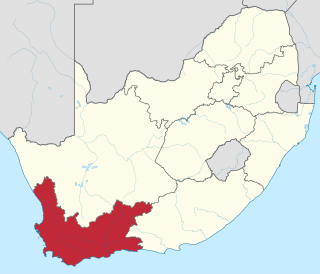
Harkerville | |
|---|---|
| Coordinates: 34°01′59″S23°13′59″E / 34.033°S 23.233°E Coordinates: 34°01′59″S23°13′59″E / 34.033°S 23.233°E | |
| Country | South Africa |
| Province | Western Cape |
| District | Garden Route |
| Municipality | Bitou |
| Area | |
| • Total | 43.61 km2 (16.84 sq mi) |
| Population (2001) [1] | |
| • Total | 269 |
| • Density | 6.2/km2 (16/sq mi) |
| Racial makeup (2001) | |
| • Black African | 5.6% |
| • Coloured | 77.7% |
| • White | 16.7% |
| First languages (2001) | |
| • Afrikaans | 86.6% |
| • English | 13.4% |
| Time zone | UTC+2 (SAST) |
| PO box | 6604 |
Harkerville is a settlement in Garden Route District Municipality in the Western Cape province of South Africa.

The Garden Route District Municipality is a district municipality located in the Western Cape Province of South Africa. Its municipality code is DC4.

The Western Cape is a province of South Africa, situated on the south-western coast of the country. It is the fourth largest of the nine provinces with an area of 129,449 square kilometres (49,981 sq mi), and the third most populous, with an estimated 6.6 million inhabitants in 2018. About two-thirds of these inhabitants live in the metropolitan area of Cape Town, which is also the provincial capital. The Western Cape was created in 1994 from part of the former Cape Province.

South Africa, officially the Republic of South Africa (RSA), is the southernmost country in Africa. It is bounded to the south by 2,798 kilometres (1,739 mi) of coastline of Southern Africa stretching along the South Atlantic and Indian Oceans; to the north by the neighbouring countries of Namibia, Botswana, and Zimbabwe; and to the east and northeast by Mozambique and Eswatini (Swaziland); and it surrounds the enclaved country of Lesotho. South Africa is the largest country in Southern Africa and the 25th-largest country in the world by land area and, with over 57 million people, is the world's 24th-most populous nation. It is the southernmost country on the mainland of the Old World or the Eastern Hemisphere. About 80 percent of South Africans are of Sub-Saharan African ancestry, divided among a variety of ethnic groups speaking different African languages, nine of which have official status. The remaining population consists of Africa's largest communities of European (White), Asian (Indian), and multiracial (Coloured) ancestry.


