This article needs additional citations for verification .(July 2011) |
De Rust | |
|---|---|
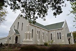 De Rust Dutch Reformed Church | |
 De Rust  De Rust | |
| Coordinates: 33°29′20″S22°32′00″E / 33.48889°S 22.53333°E | |
| Country | South Africa |
| Province | Western Cape |
| District | Garden Route |
| Municipality | Oudtshoorn |
| Area | |
• Total | 17.63 km2 (6.81 sq mi) |
| Population (2011) [1] | |
• Total | 3,566 |
| • Density | 202.3/km2 (523.9/sq mi) |
| Racial makeup (2011) | |
| • Black African | 2.5% |
| • Coloured | 87.4% |
| • Indian/Asian | 0.5% |
| • White | 8.9% |
| • Other | 0.8% |
| First languages (2011) | |
| • Afrikaans | 93.6% |
| • English | 4.1% |
| • Other | 2.3% |
| Time zone | UTC+2 (SAST) |
| Postal code (street) | 6651 |
| PO box | 6650 |
| Area code | 044 |
De Rust is a small village at the gateway to the Klein Karoo, South Africa. The name is Dutch and literally translates to "The Rest", referring to the town's original purpose of being a resting place for settlers en route through the challenging terrain of a nearby Swartberg gorge. [2]
