Herolds Bay

Last updated
Herolds Bay
Heroldsbaai
Heroldsbai vanaf uitkykpunt.JPG
View from a lookout point south west of the town.
South Africa Western Cape location map.svg
Red pog.svg
Herolds Bay
South Africa adm location map.svg
Red pog.svg
Herolds Bay
Coordinates: 34°03′02″S22°23′51″E / 34.05056°S 22.39750°E / -34.05056; 22.39750
Country South Africa
Province Western Cape
District Garden Route
Municipality George
Area
[1]
  Total1.03 km2 (0.40 sq mi)
Population
 (2011) [1]
  Total704
  Density680/km2 (1,800/sq mi)
Racial makeup (2011)
[1]
   Black African 2.7%
   Coloured 33.8%
   Indian/Asian 0.1%
   White 61.6%
  Other1.7%
First languages (2011)
[1]
   Afrikaans 89.8%
   English 9.6%
  Other0.6%
Time zone UTC+2 (SAST)

Herolds Bay (Afrikaans: Heroldsbaai) is a beach resort on the Southern Cape coast. It is 6.4 km from George Airport and can be reached by the R404 (the Skimmelkrans road).

Contents

History

The beach resort was initially part of the farm Brakfontein, then property of Dirk Lamprecht and later of Frans Gericke. The latter's descendants still have interests in the area. Although it was first known as Sandstrand, in 1823 it was named after the first vicar on George, Tobias Johannes Herold [2] , a keen angler. At first it was mainly George and people from the immediate vicinity who camped here. Later they were followed by a small group from Oudtshoorn (and especially the Kamanassie). Oompie Meyer and John Urban, both well-known residents of George, took on the task in 1904 of demarcating small plots of land for the vacationers' tents, wagons and canopies. Building materials were delivered on sleds pulled by mules. The first holiday home was built in 1895 for Matilda Howitson from Blanco. This was the first step in the development of a formal holiday resort. Before 1928, there was only one house on the west side, Sandstrand Street. This is the house west of the church and built for the sisters and girls of the Convent School on George. The list of early visitors and home owners is a list of the names of all the notables of the time in the immediate vicinity. The first permanent resident was one Thompson. He was a survivor of a shipwreck in 1920 and made his home in a beachside cave for eight years.

Swimming, fishing, surfing

The waves are a popular playground on hot days. Across from the Stella Maris Chapel, John Urban and the George Divisional Council had a large tidal pool built for swimmers in 1935. During the apartheid years, a pool was built in Skulpieshoek. Surfers are found in the bay all year round. During the summer school holidays, the municipality of George has a team of trained beach guards on duty during daylight hours.

For the angler, the area is a paradise. Eastwards a footpath leads over the rocks to Scott's Bank, Dollieskraal and Dutton's Cove. On the west side a footpath leads to Voëlklip. It can also be reached by car via the Rooikransies Road which turns south from the tarred Skimmelkrans Road. From the exit to Voëlklip it is 2½ km on a dirt road. After almost 1 km from the exit there is a parking space to walk to Rooikransies and further west to the Maalgaten River.

Access routes

In the early years, the heavily laden ox carts made their way to the bay. Especially the last steep descent must have been no easy task for man, ox and cart. Everything needed for the holiday had to be taken along, including live chickens that would be part of the Christmas meal. On arrival, the oxen were herded into the sea to get rid of their ticks. After that they and the wagons went back to the plateau where the Gerickes took care of them until the retreat was started.

In 1911 the first road to Herolds Bay was built. It roughly followed the track of the bullock carts from George. Between the current Bos-en-Dal neighbourhood and the railway, across the farm Soutkloof, through the Gwaing River and past the farm Dutton's Cove. Near the sea the road, now known as the Rooidraai Road, was very steep.

In 1958 the tarmac road from the N2 national road to Herolds Bay was completed. At the airport, the R404 turns away, takes a bridge over the railway line near the Skimmelkrans station and a pass in the Brakfontein cliff. In 1999 the Rooidraai Road (from Heroldsbaai Heights to the bay) was paved. Three years later, the old road from Skimmelkrans station to Herolds Bay Heights was rebuilt and tarred. With this route, Herolds Bay is 6 km from the N2.

Church

Herolds Bay's Roman Catholic church. HeroldsbaaiRoomsekerk.JPG
Herolds Bay's Roman Catholic church.

In 1933, the Roman Catholic Church built a chapel next to their house. John Urban and his wife (of the famous Urban shoe factory on George) donated the land and were also closely involved in the building of the chapel. Today, the Stella Maris Chapel is a well-known landmark in the settlement.

The church hall of the Dutch Reformed Church was built in 1941 on the plot donated for the purpose by Cecil Gericke. Fresh water was, as with many beach resorts, a problem from the start. The church took advantage of the opportunity by selling fresh water to pay off their building loan. In 1987, the church hall was converted into a church centre with the addition of two youth homes. Currently it is the property of the Dutch Reformed congregation George-Suid.

Development

There have been guest houses since the early 1940s. There is one shop that is open throughout the year. During the school holidays and weekends there are a few kiosks along the beach.

Herolds Bay has few permanent residents. Most houses are very modest and date from the first half of the last century. Some of these old houses have been demolished and replaced with double-storey buildings. Where the Skimmelkrans Road dead ends, Ernie Els had a house built next to the beach.

In 1972, part of the farm Buffelsfontein on the plateau was converted into the Herolds Bay Heights residential area. There are many permanent residents who mostly work in George. With this development, Herolds Bay is also connected to George's electricity, water and sewer network. This benefited further development. Several people also live at the nearby golf estate at Oubaai (Dutton's Cove).

Dangers

In June 1935 Herolds Bay was hit by the highest flood in human memory. It was also accompanied by heavy downpours and caused the Brakfontein brook to run strongly. A plaque in the gorge shows the highest water level recorded at the time. Between Christmas and New Year 1949 it rained so much that the muddy water ran down the slopes through houses and tents. Ten years later, a stormy sea caused damage again. Girls from the convent school on George who were in their beach house had to climb up the head to get away while their trunks were washed around in the waves. In 1980, a reinforced sea wall was built to try to prevent damage to the coastal properties. Again between Christmas and New Year, but now in 2008, the sea was so rough that it covered Skimmelkrans Lane and Sandstrand Street up to the houses with a thick layer of foam.

Sea currents on the western as well as the eastern side of the bay are extremely treacherous. Several bathers have already drowned here and anglers have been knocked off the rocks by freak waves.

Vegetation

Coastal winds from the south carry air with a lot of salt to the land. Together with the dry summers, this causes the fynbos to remain particularly low on the slopes on the sea side. In the sheltered Brakfonteinkloof, the vegetation is significantly higher. This low fynbos is unique in this small area. Unfortunately, one-third of the original fynbos has already been lost to development. Milkwood trees that grew right up to the beach were all lost.

Home remedies against the ever-dreaded blue blisters have been applied for years. To relieve the pain, the fresh leaves of the sour fig and the creeper were applied to the burn marks to relieve the pain.

Archaeology

For many centuries, the first inhabitants of the area fished and collected shellfish. Behind the house Klamarni and adjacent houses is a cave of great archaeological interest. Remains in it indicate that it was inhabited by humans and animals some 100,000 years ago. According to Marincowitz, bones of the extinct bluebuck (Hippotragus leucophaeus) were found in it. In 1979 the site was declared a national monument.

Geology

The rocks in the bay were deposited between 600 and 900 million years ago as clay and muddy sand. About 580 million years ago it came under pressure from the southwest and the rocks were folded, broken and cracked. At the same time, granite seeped into the cracks in the form of magma with a temperature of up to 1,000 degrees Celsius. With the result that the sediment was heated to about 600 degrees C and changed into the rocks that are found there today.

On Herolds Bay the cracks and folds were more intense than elsewhere on this coast. This can be seen in the rocks at the older tidal pool and the contact between the sediment and granite on the east side of the bay. These cracks weakened the rock so that it was eroded more quickly by the waves. This is what made the Herolds Bay of today, because the Brakfontein Spruit never runs so strong that it could have formed the bay on its own.

See also

Related Research Articles

<span class="mw-page-title-main">Seaside resort</span> Resort located on the coast

A seaside resort is a city, town, village, or hotel that serves as a vacation resort and is located on a coast. Sometimes the concept includes an aspect of official accreditation based on the satisfaction of certain requirements, such as in the German Seebad. Where a beach is the primary focus for tourists, it may be called a beach resort.

<span class="mw-page-title-main">Bude</span> Town in Cornwall, England

Bude is a seaside town in north east Cornwall, England, United Kingdom, in the civil parish of Bude-Stratton and at the mouth of the River Neet. It was sometimes formerly known as Bude Haven. It lies southwest of Stratton, south of Flexbury and Poughill, and north of Widemouth Bay, located along the A3073 road off the A39. Bude is twinned with Ergué-Gabéric in Brittany, France. Bude's coast faces Bude Bay in the Celtic Sea, part of the Atlantic Ocean. The population of the civil parish can be found under Bude-Stratton.

<span class="mw-page-title-main">Salcombe</span> Town in Devon, England

Salcombe is a popular resort town in the South Hams district of Devon, south west England. The town is close to the mouth of the Kingsbridge Estuary, mostly built on the steep west side of the estuary. It lies within the South Devon Area of Outstanding Natural Beauty (AONB). The town's extensive waterfront and the naturally sheltered harbour formed by the estuary gave rise to its success as a boat and shipbuilding and sailing port and, in modern times, tourism especially in the form of pleasure boats and yachting. The town is also home to a traditional shellfish fishing industry. The town is part of the electoral ward of Salcombe and Malborough, for which the 2011 census recorded a total population of 3,353.

<span class="mw-page-title-main">Croyde</span> Village in Devon, England

Croyde is a village on the west-facing coastline of North Devon, England. The village lies on the South West Coast Path near to Baggy Point, which is owned by the National Trust. It lies within the North Devon Coast Area of Outstanding Natural Beauty.

<span class="mw-page-title-main">Dawlish</span> Seaside town in Devon, England

Dawlish is an English seaside resort town and civil parish in Teignbridge on the south coast of Devon; it is located 12 miles (19 km) from the county town of Exeter and from the larger resort of Torquay. Its 2011 population of 11,312 was estimated to have risen to 13,355 by 2019. It is to grow further as several housing estates are under construction, mainly in the north and east of the town. It had grown in the 18th century from a small fishing port into a well-known seaside resort, as had its near neighbour, Teignmouth, in the 19th century. Between Easter and October, the population can swell by an additional 20,000, largely in self-accommodation, caravan, camping and holiday parks.

<span class="mw-page-title-main">Criccieth</span> Town and community in Gwynedd, Wales

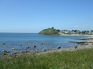
Criccieth is a town and community in Gwynedd, Wales, on the boundary between the Llŷn Peninsula and Eifionydd. The town is 5 miles (8 km) west of Porthmadog, 9 miles (14 km) east of Pwllheli and 17 miles (27 km) south of Caernarfon. It had a population of 1,826 in 2001, reducing to 1,753 at the 2011 census.

<span class="mw-page-title-main">Plettenberg Bay</span> Place in Western Cape, South Africa

Plettenberg Bay, nicknamed Plet or Plett, is the primary town of the Bitou Local Municipality in the Western Cape Province of South Africa. As of the census of 2001, there were 29,149 population. It was originally named Bahia Formosa by early Portuguese explorers and lies on South Africa's Garden Route 210 km from Port Elizabeth and about 600 km from Cape Town.

<span class="mw-page-title-main">Punaluʻu Beach</span> Black Sand Beach, Big Island, Hawaii, US

Punaluʻu Beach is a beach between Pāhala and Nāʻālehu on the Big Island of the U.S. state of Hawaii. The beach has black sand made of basalt and created by lava flowing into the ocean which explodes as it reaches the ocean and cools. This volcanic activity is in the Hawaiʻi Volcanoes National Park. Punaluʻu is frequented by endangered hawksbill and green turtles, which can often be seen basking on the black sand.

<span class="mw-page-title-main">Kilkee</span> Seaside resort in County Clare, Ireland

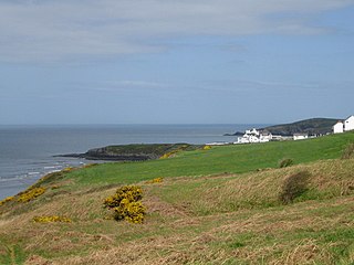
Kilkee is a small coastal town in County Clare, Ireland. It is in the parish of Kilkee, formerly Kilfearagh. Kilkee is midway between Kilrush and Doonbeg on the N67 road. The town is popular as a seaside resort. The horseshoe bay is protected from the Atlantic Ocean by the Duggerna Reef.

<span class="mw-page-title-main">Porthcurno</span> Village in Cornwall, England

Porthcurno is a small village covering a small valley and beach on the south coast of Cornwall, England in the United Kingdom. It is the main settlement in a civil and an ecclesiastical parish, both named St Levan, which comprise Porthcurno, diminutive St Levan itself, Trethewey and Treen.

<span class="mw-page-title-main">Woolacombe</span> Village in Devon, England

Woolacombe is a seaside resort on the coast of North Devon, England, which lies at the mouth of a valley in the parish of Mortehoe. The beach is 2 miles (3.2 km) long, sandy, gently sloping and faces the Atlantic Ocean near the western limit of the Bristol Channel.

<span class="mw-page-title-main">Cadgwith</span> Human settlement in England

Cadgwith is a village and fishing port in Cornwall, England, United Kingdom. It is on the Lizard Peninsula between The Lizard and Coverack. It is in the civil parish of Grade Ruan.

<span class="mw-page-title-main">Helderberg</span> Region of the City of Cape Town, South Africa

Helderberg refers to a planning district of the City of Cape Town metropolitan municipality, the mountain after which it is named, a wine-producing area in the Western Cape province of South Africa, or a small census area in Somerset West.

<span class="mw-page-title-main">Sennen Cove</span> Coastal village in Cornwall, England

Sennen Cove is a small coastal village in the parish of Sennen in Cornwall, England, United Kingdom. According to the Penwith District Council, the population of this settlement was estimated at 180 persons in 2000. The South West Coast Path passes through Sennen Cove.

Langland Bay is a popular coastal holiday resort in Gower, Swansea in south Wales. It is a popular surfing beach which regularly meets the European Blue Flag award for quality.

<span class="mw-page-title-main">Santa Margalida</span> Municipality in Balearic Islands, Spain

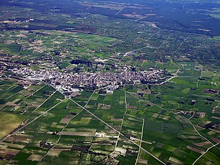
Santa Margalida is a municipality with a population of 10,204 located in the northeast of the Spanish Balearic Island Majorca.

<span class="mw-page-title-main">Trebarwith Strand</span> Section of coastline in Northern Cornwall, UK

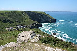
Trebarwith Strand is a section of coastline located near the coastal settlement of Trebarwith on the north coast of Cornwall, England, UK, 2+12 miles (4.0 km) south of Tintagel. It has 800m of sandy beach contained by cliffs in which natural caves are found. The beach can only be accessed at low tide. The strand was once used to land ships to export slate from the nearby quarries while sand from the beach was used for agricultural purposes. The view from the beach is dominated by rocks 300m offshore known as Gull Rock or Otterham Rocks.

<span class="mw-page-title-main">Victoria Bay</span> Place in Western Cape, South Africa

Victoria Bay is a small cove in the Western Cape, South Africa. It is situated on the Garden Route between George and Wilderness. It is a popular beach for surfers, consisting of a right hand reef-like wave which rolls over small boulder-like rocks for about 200m. District and National surf competitions are often held at Vic Bay and despite its small size, Vic Bay is a well-known and much-visited spot.

<span class="mw-page-title-main">Gwbert</span> Human settlement in Wales

Gwbert, also known as Gwbert-on-Sea, is a cliff-top coastal village in Y Ferwig community, Ceredigion, Wales. It lies at the most southerly coastal point of Ceredigion, on the eastern shore of the Teifi estuary, from where there are views westwards over Cardigan Bay, and south-westwards to Poppit Sands and the headland of Cemaes Head, in neighbouring Pembrokeshire. It is reached by the B4548 road from the town of Cardigan, 2.8 miles (4.5 km) away.

<span class="mw-page-title-main">Miller's Point, Western Cape</span> Place in Western Cape, South Africa

Miller's Point is a headland and stretch of protected coastline in South Africa. It is located about 4 kilometres (2.5 mi) south of Simon's Town on the road to Cape Point.

References

  1. 1 2 3 4 "Main Place Herolds Bay". Census 2011.
  2. "Dictionary of Southern African Place Names (Public Domain)". Human Science Research Council. p. 208.