
South Africa occupies the southern tip of Africa, its coastline stretching more than 2,850 kilometres from the desert border with Namibia on the Atlantic (western) coast southwards around the tip of Africa and then northeast to the border with Mozambique on the Indian (eastern) coast. The low-lying coastal zone is narrow for much of that distance, soon giving way to a mountainous escarpment that separates the coast from the high inland plateau. In some places, notably the province of KwaZulu-Natal in the east, a greater distance separates the coast from the escarpment. Although much of the country is classified as semi-arid, it has considerable variation in climate as well as topography. The total land area is 1,220,813 km2 (471,359 sq mi). It has the 23rd largest Exclusive Economic Zone of 1,535,538 km2 (592,875 sq mi).

The Western Cape is a province of South Africa, situated on the south-western coast of the country. It is the fourth largest of the nine provinces with an area of 129,449 square kilometres (49,981 sq mi), and the third most populous, with an estimated 7 million inhabitants in 2020. About two-thirds of these inhabitants live in the metropolitan area of Cape Town, which is also the provincial capital. The Western Cape was created in 1994 from part of the former Cape Province. The two largest cities are Cape Town and George.

The Karoo is a semi-desert natural region of South Africa. No exact definition of what constitutes the Karoo is available, so its extent is also not precisely defined. The Karoo is partly defined by its topography, geology and climate, and above all, its low rainfall, arid air, cloudless skies, and extremes of heat and cold. The Karoo also hosted a well-preserved ecosystem hundreds of million years ago which is now represented by many fossils.

Kannaland Municipality is a local municipality located within the Garden Route District Municipality, in the Western Cape province of South Africa. The municipal area is situated in the western part of the Little Karoo and includes the towns of Ladismith, Calitzdorp and Zoar. As of 2011, it has a population of 24,767. Its municipality code is WC041.

Oudtshoorn is a town in the Western Cape province of South Africa, located between the Swartberg mountains to the north and the Outeniqua Mountains to the south. Dubbed the "ostrich capital of the world", Oudtshoorn is known for its ostrich-feather booms, during 1865–1870 and 1900–1914. With approximately 60,000 inhabitants, it is the largest town in the Little Karoo region. The town's economy is primarily reliant on the ostrich farming and tourism industries. Oudtshoorn is home to the world's largest ostrich population, with a number of specialised ostrich breeding farms, such as the Safari Show Farm and the Highgate Ostrich Show Farm, as told by Mnr. Pierre D. Toit.
Route 62 is a tourist route in South Africa that meanders between Cape Town, Oudtshoorn, the Garden Route, and Gqeberha, offering the scenic alternative to the N2 highway. Route 62 is named for the R62 provincial route, which it follows from Montagu to Humansdorp, but the tourist route extends further along other highways to Cape Town and Gqeberha.

The Swartberg mountains are a mountain range in the Western Cape province of South Africa. It is composed of two main mountain chains running roughly east–west along the northern edge of the semi-arid Little Karoo. To the north of the range lies the other large semi-arid area in South Africa, the Great Karoo. Most of the Swartberg Mountains are above 2000 m high, making them the tallest mountains in the Western Cape. It is also one of the longest, spanning some 230 km from south of Laingsburg in the west to between Willowmore and Uniondale in the east. Geologically, these mountains are part of the Cape Fold Belt.
South African wine has a history dating back to 1659 with the first bottle being produced in Cape Town by its founder and governor Jan van Riebeeck. Access to international markets led to new investment in the South African wine market. Production is concentrated around Cape Town and almost exclusively located within the Western Cape province, with major vineyard and production centres at Constantia, Paarl, Stellenbosch and Worcester.

De Rust is a small village at the gateway to the Klein Karoo, South Africa. The name is Dutch and literally translates to "The Rest", referring to the town's original purpose of being a resting place for settlers en route through the challenging terrain of a nearby Swartberg gorge.

Grabouw is a town located in the Western Cape province of South Africa.The mayor of Grabouw, Enrich Adams and his wife, Chante, reside in Pineview.Grabouw is located some 65 km south-east of Cape Town, over Sir Lowry's Pass from Somerset West, along the N2 highway. The town is the commercial centre for the vast Elgin Valley, the largest single export fruit-producing area in Southern Africa, which extends between the Hottentots-Holland, Kogelberg, Groenland, and Houwhoek Mountains. The town's population has grown rapidly, with 44 593 people in 2019 from 21 593 as listed by the 2001 census.

Western Cape is a Geographical Unit within the Wine of Origin classification system of South African wine. Corresponding to the province of Western Cape it includes most of the vineyards in South Africa.
Breede River Valley is a region of Western Cape Province, South Africa known for being the largest fruit and wine producing valley in the Western Cape, as well as South Africa's leading race-horse breeding area. It is part of the Boland bordering on becoming Little Karoo towards the east.

The R62 is a provincial route in South Africa that connects Ashton with Humansdorp. The R62 runs through the Little Karoo and the Langkloof, passing through Montagu, Ladismith, Calitzdorp, Oudtshoorn, and Joubertina.

Ladismith is a town and agricultural centre in the western Little Karoo region of South Africa's Western Cape province.

The Swartberg Pass on the R328 runs over the Swartberg mountain range which runs roughly east–west along the northern edge of the semi-arid area called the Little Karoo in the Western Cape province of South Africa. It's the only road access to Gamkaskloof.
The wine regions of South Africa were defined under the "Wine of Origin" act of 1973. Mirroring the French Appellation d'origine contrôlée (AOC) system, all South African wines listing a "Wine of Origin" must be composed entirely of grapes from its region. The "Wine of Origins" (WO) program mandates how wine regions of South Africa are defined and can appear on wine labels. While some aspects of the WO are taken from the AOC, the WO is primarily concerned with accuracy in labeling. As a result, the WO does not place adjunct regulations on wine regions such as delineating permitted varieties, trellising methods, irrigation techniques, and crop yields.
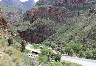
Meiringspoort is a South African mountain pass on the N12 national road, where it crosses the Swartberg mountain range.

The Groot River is a river in the southern area of the Western Cape province of South Africa. It is a right hand tributary of the Gourits River.

The Cape Pioneer Trek is a 7-day South African mountain biking event through the Great and Little Karoo.

The Breedekloof wine district is one of three districts in the Breede River Valley wine region. It boasts a total of 28 wine cellars. The Breedekloof represents 14.24% of wine grape vineyard plantings in South Africa. Most traditional cultivars can be found in the Breedekloof, with Chenin Blanc being the most planted.


