
South Africa occupies the southern tip of Africa, its coastline stretching more than 2,850 kilometres from the desert border with Namibia on the Atlantic (western) coast southwards around the tip of Africa and then northeast to the border with Mozambique on the Indian Ocean. The low-lying coastal zone is narrow for much of that distance, soon giving way to a mountainous escarpment that separates the coast from the high inland plateau. In some places, notably the province of KwaZulu-Natal in the east, a greater distance separates the coast from the escarpment. Although much of the country is classified as semi-arid, it has considerable variation in climate as well as topography. The total land area is 1,220,813 km2 (471,359 sq mi). It has the 23rd largest Exclusive Economic Zone of 1,535,538 km2 (592,875 sq mi).

The Saône is a river of eastern France. It is a right tributary of the Rhône, rising at Vioménil in the Vosges department and joining the Rhône in Lyon, just south of the Presqu'île.

The Zambezi River is the fourth-longest river in Africa, the longest east-flowing river in Africa and the largest flowing into the Indian Ocean from Africa. The area of its basin is 1,390,000 square kilometres (540,000 sq mi), slightly less than half of the Nile's. The 2,574-kilometre-long river (1,599 mi) arises in Zambia and flows through eastern Angola, along the north-eastern border of Namibia and the northern border of Botswana, then along the border between Zambia and Zimbabwe to Mozambique, where it crosses the country to empty into the Indian Ocean.

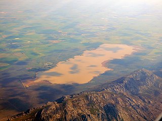
The Vaal Dam in South Africa was constructed in 1938 and lies 77 km south of OR Tambo International Airport. The lake behind the dam wall has a surface area of about 320 square kilometres (120 sq mi) and is 47 meters deep. The Vaal Dam lies on the Vaal River, which is one of South Africa's strongest-flowing rivers. Other rivers flowing into the dam are the Wilge River, Klip River, Molspruit and Grootspruit. It has over 800 kilometres (500 mi) of shoreline and is South Africa's second biggest dam by area and the fourth largest by volume.

The Karoo is a semi-desert natural region of South Africa. No exact definition of what constitutes the Karoo is available, so its extent is also not precisely defined. The Karoo is partly defined by its topography, geology and climate, and above all, its low rainfall, arid air, cloudless skies, and extremes of heat and cold. The Karoo also hosted a well-preserved ecosystem hundreds of million years ago which is now represented by many fossils.
The Olifants River is a river in the northwestern area of the Western Cape Province of South Africa. The upper and main catchment area of the Olifants river is around Ceres and the Cederberg mountains. The Clanwilliam and Bulshoek dams are located on the river and provide water for the towns and farms along the watercourse. The river is approximately 285 km long with a catchment area of 46,220 km2 and flows into the Atlantic Ocean at Papendorp, 250 km north of Cape Town.

The Great Fish River is a river running 644 kilometres (400 mi) through the South African province of the Eastern Cape. The coastal area between Port Elizabeth and the Fish River mouth is known as the Sunshine Coast. The Great Fish River was originally named Rio do Infante, after João Infante, the captain of one of the caravels of Bartolomeu Dias. Infante visited the river in the late 1480s.

The San Juan River is, together with the Jáchal, the most important river of the Argentine province of San Juan. Both join the Desaguadero/Colorado system that ends at the Atlantic Ocean.

Olifants River is a river in the Klein Karoo area of the Western Cape, South Africa.

The Shashe River is a major left-bank tributary of the Limpopo River in Zimbabwe. It rises northwest of Francistown, Botswana and flows into the Limpopo River where Botswana, Zimbabwe and South Africa meet. The confluence is at the site of the Greater Mapungubwe Transfrontier Conservation Area.

The Groot River is a river in the southern area of the Eastern Cape province of South Africa. It is a right hand tributary of the Gamtoos River. This river passes through Steytlerville.
Beervlei Dam is a dam in the Groot River, Eastern Cape, South Africa. It was established in 1957, has a capacity of 85,800,000 cubic metres (3.03×10⁹ cu ft), and a surface area of 23.145 square kilometres (8.936 sq mi), and the dam wall is 31 m high. The main purpose of the dam is to provide flood absorption. The Karoo sediments in the area contain a lot of salts and it has been found that lengthy storage of water results in high water salinity. Any flood water is used as quickly as possible by the downstream irrigators and the reservoir is kept empty for extended periods.
Voëlvlei Dam is a dam located in the Western Cape, South Africa near the town of Gouda. The earth-fill wall is 2,910 metres (9,550 ft) long and 10 metres (33 ft) high. The reservoir covers an area of 1,524 hectares and has a capacity of 168,000 megalitres, making it the second-largest reservoir in the Western Cape Water Supply System. Water from the reservoir is supplied to water treatment works of the City of Cape Town and the West Coast District Municipality, and can also be released into the Berg River for agricultural purposes or to fill the Misverstand Dam.
Gamka River is a river located in the Western Cape, South Africa. The name 'Gamka' means 'Lion' and was probably named so by the San people (Bushmen). The river originates north of Beaufort West, generally flowing southwest towards the Gamkapoort Dam.

Gourits River, sometimes spelled 'Gouritz River', is situated in the Western Cape, South Africa.
The Touws River is a river in the Western Cape province of South Africa. It is a tributary of the Groot River, part of the Gourits River basin.

The Notwane River is a river in southeastern Botswana. Certain sections of its course form the international boundary with South Africa. Its mouth is at the head of the Limpopo River. It has a catchment area of 18,053 square kilometers.

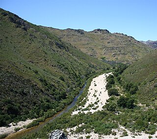
Buffelspoort is the westernmost of five defiles that cut through the Swartberg Mountain range, situated in the Western Cape province of South Africa. The others are the Seweweekspoort, Die Poort, where the Gamka River transects Die Hel, Meiringspoort, and Snykloof at its eastern extremity.
The Hex River is a tributary of the Breede River located in the Western Cape of South Africa. The most important settlements along the river are the small towns of De Doorns and Touws River.
The Klein Berg River is a major right-hand tributary of the Berg River in the Western Cape province of South Africa. The Klein Berg drains the Tulbagh basin through the Nuwekloof into the Swartland, where it joins the Berg.

